Powder Forecast – Tuesday, November 26th, 2019
Ted Schlaepfer CCM —- Mammoth Mountain WeatherGuy
Snowfall forecasts are valid at the Sesame snow course (Main Lodge) for the prior 24 hours as reported in the 6-7 AM morning snow report.
**Snowfall forecast confidence ranges from very low (1) to very high (5)
Wed 11/27 = 20 – 24” (H20 = 1.75” -2.00”)**4
Thu 11/28 = 15 – 20” (H20 = 1.00” -1.25”)**4
Fri 11/29 = 4 – 6” (H20 = 0.20” -0.35”)**4
Sat 11/30 = 1 – 3”
Sun 12/1 = 9 – 12”
Mon 12/2 = 12 – 18”
Tue 12/3 = 6 – 9”
Wed – Fri 12/4 – 12/6 = 6 – 12”
November Snowfall = 2”
November Forecast = 40 – 50”
Detailed 4-day Snowfall Forecast:
Wed 11/27 —Heavy snow and strong winds during the early morning changes to moderate snow and breezy winds during the day and through the night before decreasing early Thanksgiving. Cold. Accumulations 15 – 20” by Thu AM with 24” up top
Thu 11/28 —Light to moderate snow is expected at times during the day and overnight. Continued cold, but not as windy. Accumulations 4 – 6” by Fri AM with 8”+ up top
Fri 11/29 —Light snow showers expected during the day, ending in the evening. Cold. Accumulations 1 – 3” by Sat AM
Sat 11/30 —Dry through early afternoon, then snow develops by late PM and evening and becomes moderate overnight. Accumulations 9 – 12” by Sun AM with 12”+ up top
Forecast Summary:
Short Term (Days 1 – 4):
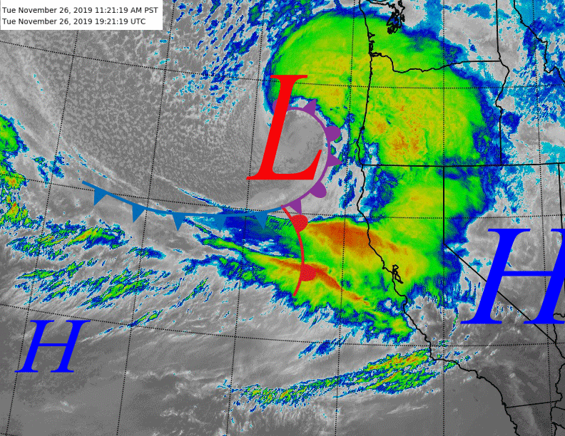
Satellite imagery (image below) shows a strong surface low-pressure system and associated fronts moving into NorCal this afternoon. Clouds will continue to build through this afternoon with snowfall becoming likely by sunset.
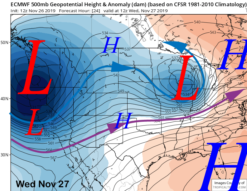
A deep upper-level trough (image below) and polar jet stream (blue arrow) will drive the low-pressure system and front southward overnight and heavy snowfall and strong winds will develop after midnight and continue into the early morning hours. Looks like up to two feet is possible by tomorrow morning at Main.
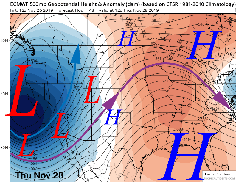
The upper-level trough will sink southward through Thanksgiving Day (image below) and continued moderate snowfall is expected through Wednesday night followed by light to moderate snow at times through Friday. Snow is also expected at times across most of the Owens Valley in addition to parts of the high desert. SoCal mountain passes will also see snowfall.
As mentioned in the last post, this will be light and fluffy snowfall and not Sierra cement. Snow ratios will likely be 12-15”:1” with the initial front and then 15-20”:1” Wednesday into Friday when the coldest air is in place.
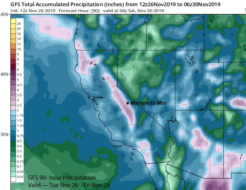
Looks like at least 3 feet should fall at Main with this event and around four feet up top as models are showing almost 3″ liquid (image below).
Temperatures will also get quite cold and remain in the single digits and teens on the mountain during operation hours
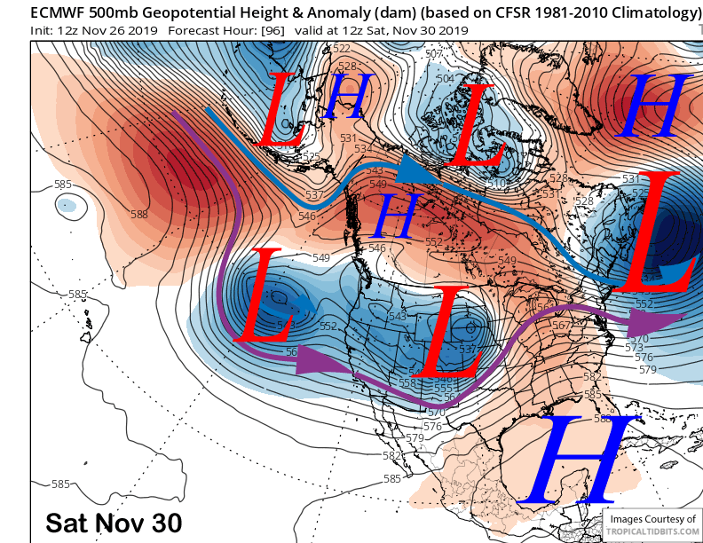
The system will finally exit eastward Friday night and early Saturday (image below) for a brief period of dry weather before the next weather system moves into the area by Saturday night.
Long Range (Days 5+):
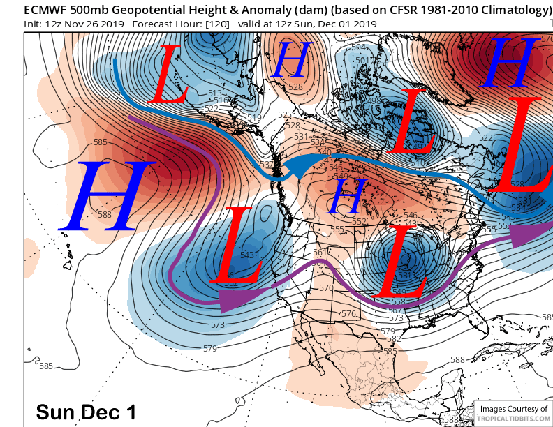
Another significant storm system is then favored to move into California next weekend and into the following week. Models move the next upper-low onto the coast by early Sunday (image below) and this system will be warmer and also have more available moisture with the southern branch of the jet stream (purple arrow) lined up right into Mammoth.
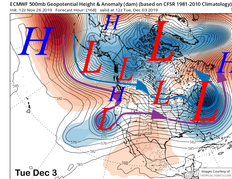
The upper-level low-pressure system will remain mostly stationary through Monday before weakening and moving southward by early Tuesday (image below). That means nearly continuous pulses of moisture and snowfall will move into the Sierra for about 48-60 hours.
Decent chance that a weak Atmospheric River sets up across central California and into the Sierra.
Models are showing good amounts of precipitation with this next event. GFS 24-hour accumulations (images below) show about an inch or more each day through Monday with Sunday seeing the most precipitation. Totals are almost 5 inches of liquid throughout the period. ECM is showing over 3 inches of liquid.
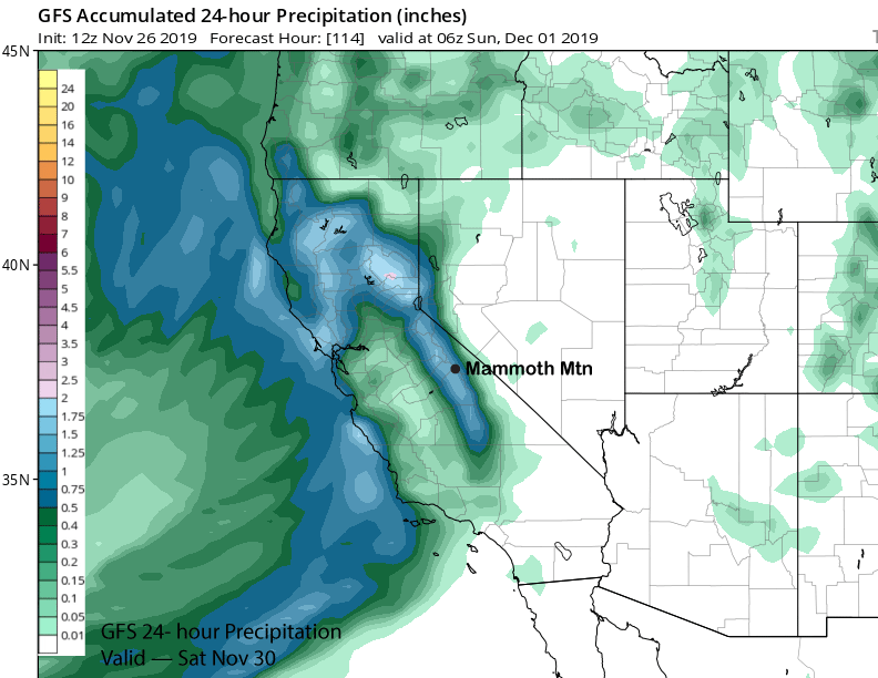
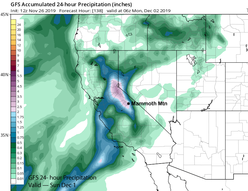
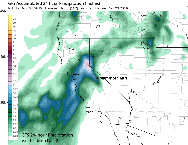
Snow levels will be higher with this storm after starting out low Saturday evening before the cold air in place mixes out. Looks like levels will rise to 5000 feet by early Sunday and then around 7000 feet by early Monday.
That means this storm will have the more typical Sierra cement type snow and ratios in the 10”:1” range. Amounts should be at least two feet at Main and possibly more. Unfortunately, this storm is not happening first.
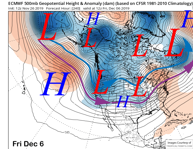
After a break on Wednesday, models (ECM below) are favoring the passage of another trough of low pressure around Thursday/Friday for another round of snowfall, It doesn’t look like a major storm right now, but it is still 9-10 days out and confidence is low in the details. WG