Powder Forecast – Tuesday, December 10th, 2019
Ted Schlaepfer CCM —- Mammoth Mountain WeatherGuy
Snowfall forecasts are valid at the Sesame snow course (Main Lodge) for the prior 24 hours as reported in the 6-7 AM morning snow report.
**Snowfall forecast confidence ranges from very low (1) to very high (5)
Wed 12/11 = 0 – 1”
Thu 12/12 = 0 – trace”
Fri 12/13 = 0 – 1”
Sat 12/14 = 2 – 3” (H20 = 0.25″ – 0.45″)*2
Sun 12/15 = 3 – 5” (H20 = 0.30″ – 0.60″)*2
Mon 12/16 = 0”
Tue 12/17 = 0”
Wed – Fri 12/18– 12/20 = 3 – 9”
December Snowfall = 45”
December Forecast = 70 -90”
Detailed 4-day Snowfall Forecast:
Wed 12/11 — Early morning light snow possible before dawn, then dry. Maybe an inch accumulation.
Thu 12/12 —A chance for flurries early in the morning, otherwise dry until Thursday night when light snowfall is possible. Maybe an inch accumulation by Friday.
Fri 12/13 —Flurries during the morning turn into steady light snowfall by the late afternoon and overnight. Accumulations 2 – 3”, up to 6” up top by Saturday AM
Sat 12/14 —Light to moderate snowfall possible by the afternoon and evening, tapering off overnight. Accumulations 3 – 5” by Sunday AM, 6”+ up top
Forecast Summary:
Short Term (Days 1 – 4):
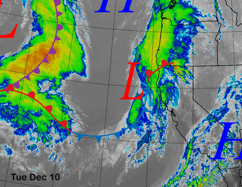
Satellite imagery today (image below) shows a low-pressure system and front about to move onto the northern California coast. That weak system is part of a splitting upper air trough and will fall apart shortly after landfall. Nonetheless, there is a chance for a couple of hours of light snowfall late tonight that could result in an inch accumulation.
The next system on the edge of the satellite image will move into NorCal by Wednesday night with the jet stream flow keeping it mostly north of Mammoth during its passage Thursday and into early Friday (image below). The system will still cause lots of cloudiness and flurries or light snow showers at times, primarily Thursday night when there could be some light snowfall.
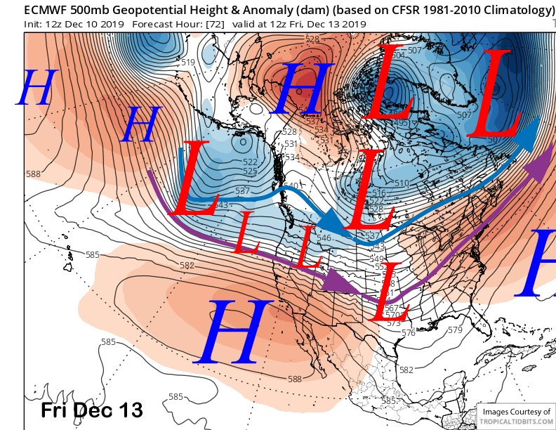
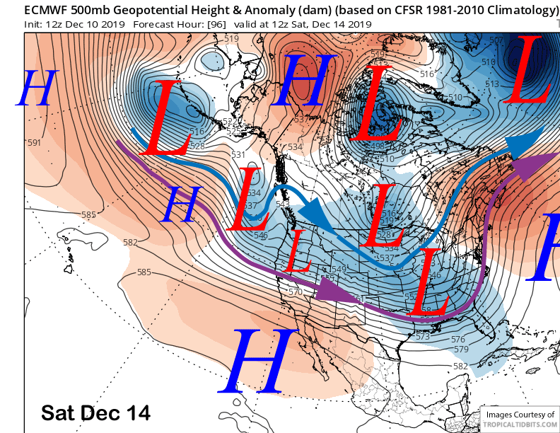
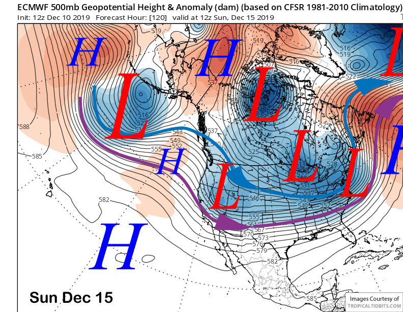
The jet stream (purple arrow) moves southward by early Saturday (image below) and snowfall will likely increase by the afternoon and night when periods of moderate snowfall are possible.
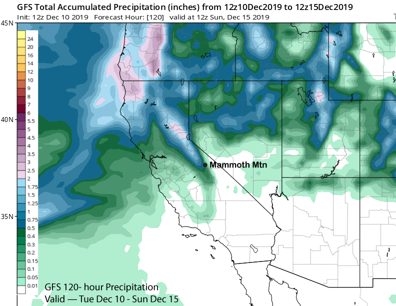
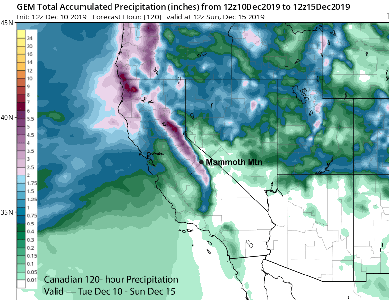
GFS (image below) and ECM models are showing around a half an inch of liquid for the event and maybe up to 6 inches total snowfall. Canadian (two images below) is showing higher amounts and around 2” liquid as it keeps the subtropical tap stronger. Snow levels will be near 8500 feet Thursday night, 8000 feet Friday, 7000 feet by Saturday morning, finally dropping to near 5000 feet by Saturday night. So any snow that falls will be rather wet and relative humidity will be higher as this system will have lots of subtropical moisture with a drier layer of snowfall at the end of the event.
Long Range (Days 5+):
The upper-level trough finally moves through CA by early Sunday (image below) and colder and dry air moves into the area resulting at the end of the snowfall. The dry and seasonably cold weather should then continue through Monday and into Tuesday as high pressure rebuilds over California.
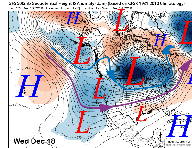
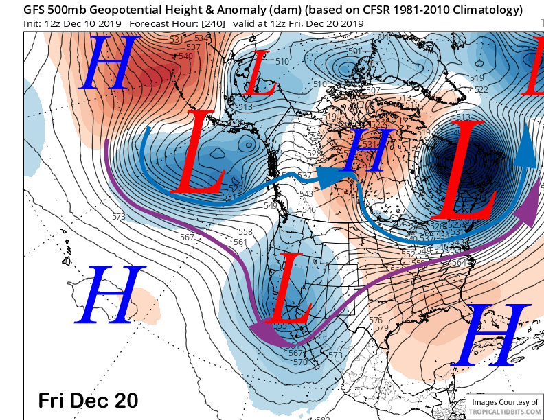
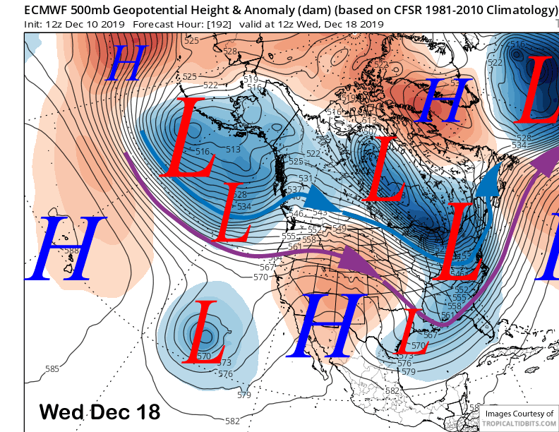
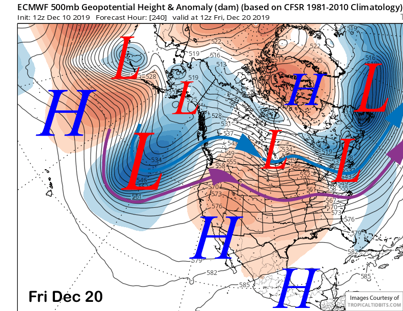
Models are then divided with the longer-range forecast with the latest GFS having a more favorable solution for snowfall and the ECM favoring dry weather. The GFS moves an upper-level trough into CA by early Wednesday (image below) next week that would result in colder temperatures and light/moderate snowfall. It keeps the trough in place until early Friday (two images below).
The ECM model develops that Tuesday/Wednesday trough into a cut-off off SoCal with a ridge over CA mid-week and it keeps it there into the end of the week for dry weather and not as cold temperatures. That solution is basically opposite to the GFS.
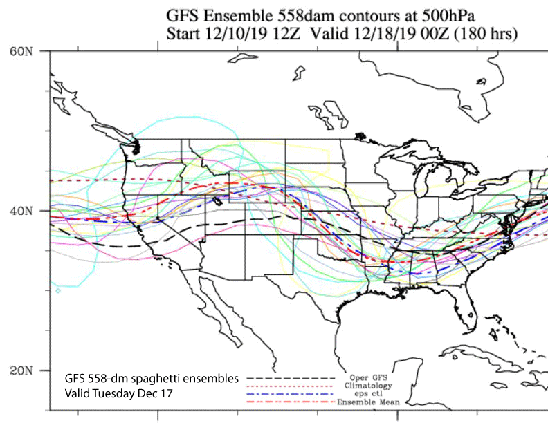
GFS ensembles (image below) are favoring the trough solution over the ridge solution with only a few members showing the ECM run. ECM ensembles are a full-on mess for early next week with the members becoming very divided starting on Tuesday. At least a handful shows the GFS solution with many more favoring a trough passage around Thursday.
So the best forecast right now is for some light to moderate snowfall around mid-week of next week. Confidence is certainly low overall and no guarantee that enough could fall for powder conditions. Super long-range guidance does have another chance for snowfall before Christmas. WG


