Powder Forecast –Friday, January 10th, 2020
Ted Schlaepfer CCM —- Mammoth Mountain WeatherGuy
Snowfall forecasts are valid at the Sesame snow course (Main Lodge) for the prior 24 hours as reported in the 6-7 AM morning snow report.
**Snowfall forecast confidence ranges from very low (1) to very high (5)
Sat 1/11 = 0”
Sun 1/12 = 0”
Mon 1/13= 0 –1”
Tue 1/14 = 4– 6” (H20 = 0.35” – 0.55”)**3
Wed 1/15 = 2– 4” (H20 = 0.20” – 0.30”)**3
Thu 1/16 = 10 – 14”
Fri 1/17 = 6– 8”
Sat-Mon 1/18– 1/20 = 2– 6”
January Snowfall = trace”
January Forecast = 30 – 45″
Detailed 4-day Snowfall Forecast:
Sat 1/11—Flurries or light snow showers are possible during the morning hours and into the early afternoon, otherwise dry. No accumulation expected. Gusty northwest winds during the morning hours, decreasing PM.
Sun 1/12— No snowfall expected during the day with a chance for flurries/light snow overnight and into early Monday. Maybe an inch accumulation by Monday AM.
Mon 1/13—No snowfall expected until overnight Monday and into Tuesday when moderate snowfall develops after midnight. Gusty west-northwest winds Monday. Accumulation 4 – 6” by Tuesday AM with 6”+ up top
Tue 1/14—Moderate snowfall during the morning hours before ending during the afternoon. Gusty northwest winds and cold. Accumulation 2 – 4” by Wednesday AM, up to 6” up top.
Forecast Summary:
Short Term (Days 1 – 4)
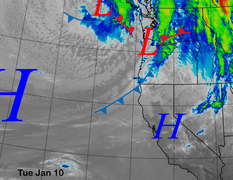
Satellite imagery this afternoon (below) shows a transitory high-pressure ridge has built over central CA with a low-pressure system and associated cold front along California/Oregon border. That front and short-wave trough (two images below) will move southward overnight while dissipating and some clouds, flurries, or even a light snow shower is possible tomorrow morning and into midday in Mammoth, but no accumulation. It will be windy during the morning though.
After a dry day Sunday, another weak system will slide southward Sunday overnight and into early Monday and that too could result in flurries or light snow showers with no more than a trace accumulation expected, if at all. Monday should be dry with breezy to gusty westerly winds.
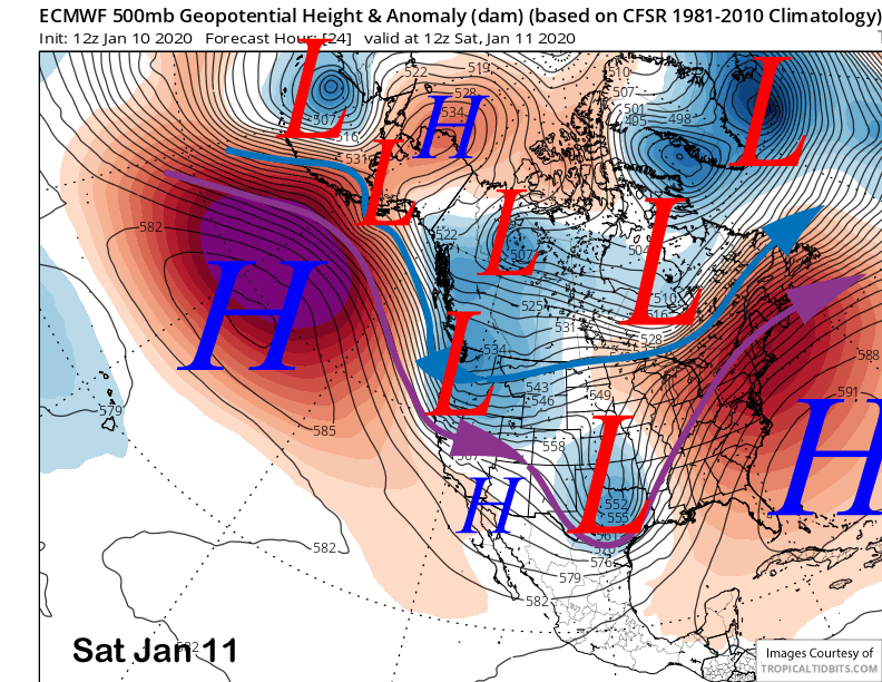
Changes in the pattern start overnight Monday and into Tuesday when these high latitude type troughs start moving southward farther west including a more over-ocean trajectory. That will help the entrainment of moisture to increase that will produce snowfall.
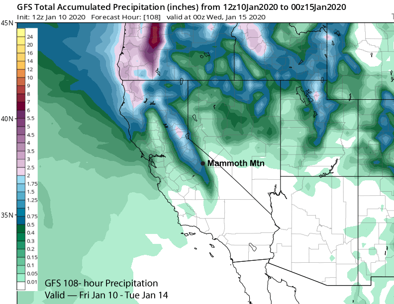
The ECM (image below) projects this next short-wave trough to move through Mammoth during the morning hours Tuesday. The GFS and Canadian are similar now after showing diverging solutions the past few days.
GFS shows about 0.75” liquid (image below) while the ECM has around 0.60” and the Canadian about 0.50”. The ECM ensemble mean has slightly over half an inch liquid and the forecast leans closer to the ECM/GFS solutions with 6-10” of snow at Main. It is a cold storm with 10,000-foot temps at -12C (teens on the mountain), so the resulting snowfall should be light and dry. Snowfall appears to end Tuesday afternoon.
Long Range (Days 5+):
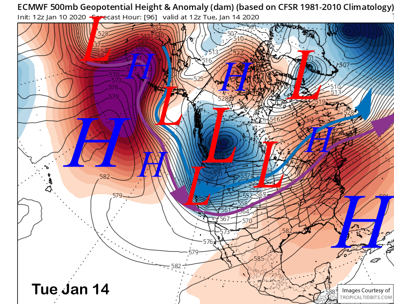
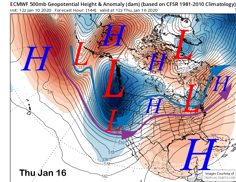
The numerical guidance has now also come into better agreement for the pattern toward the end of next week. The GFS has now trended toward the ECM solution (image below) of a very deep trough moving into California Wednesday night and Thursday morning and moving eastward faster by Friday.
It appears to be very dynamic and cold with snow levels quite low and in the 3500-4000 foot range during the heaviest period of snowfall before lowing to 2500 on the back end of the storm. However, it may also move through fairly quickly and thus limiting the total amounts, although it should certainly be enough for powder conditions.
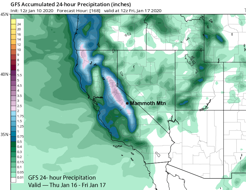
GFS 24-hour precipitation amounts (image below) during the heaviest period early Thursday morning into early Friday morning show about 1.75” liquid with the ECM almost 1.5”. Forecast leans toward the wetter GFS due to the very deep trough and strong polar jet.
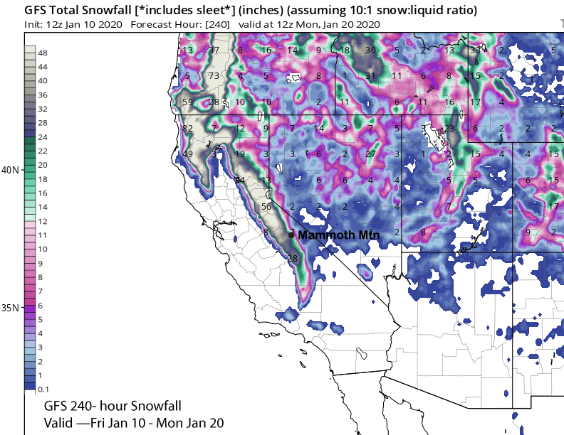
It will also be very windy and that will lead to snow crystal fracturing and will limit snow ratios into the 10-12”:1” range until the back end of the storm when the winds are lighter. It still look like close to 20” at Main and likely two feet plus up top in the powder fields of light and dry powder.
ECM cuts off the snowfall earlier than the GFS, but the latest guidance says it will basically be over by Friday when the lifts open. It should be bitterly cold Friday morning and quite cold Thursday too with temps in the upper single digits and teens. Looks like very good to epic conditions next week with the GFS showing around 30″ of snowfall (image below)
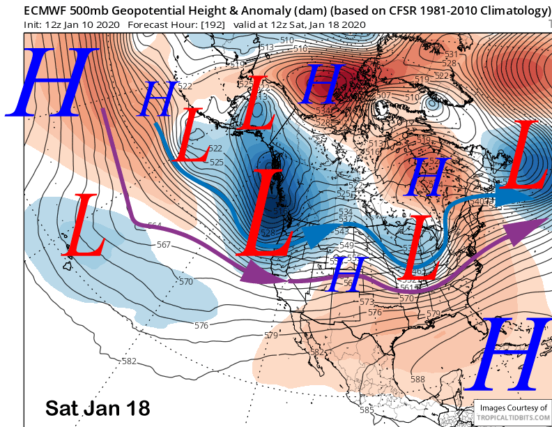
Dry weather is then expected until possibly Saturday night and into early Sunday if a trough moves into CA (image below). Models are mixed with the MLK Holiday weekend now with the GFS showing a dry ridge. Nonetheless, long-range ensembles don’t favor heavy snowfall anymore with possibly only light amounts if the ECM verifies. Drier weather is then favored for the rest of the month with possibly only weak systems. WG