Powder Forecast –Tuesday, February 4th, 2020
Ted Schlaepfer CCM —- Mammoth Mountain WeatherGuy
Snowfall forecasts are valid at the Sesame snow course (Main Lodge) for the prior 24 hours as reported in the 6-7 AM morning snow report.
**Snowfall forecast confidence ranges from very low (1) to very high (5)
Wed 2/5 = 0”
Thu 2/6 = 0”
Fri 2/7 = 0”
Sat 2/8 = 0”
Sun 2/9 = 0 – 1”
Mon 2/10 = 1 – 3”
Tue 2/11 = 1 – 2”
Wed – Fri 2/12– 2/14 = 3 – 8”
February Snowfall = 0”
February Forecast = 25 – 45″
Detailed 4-day Snowfall Forecast:
Wed 2/5 through Sat 2/8—No snowfall expected all days
Forecast Summary:
Short Term (Days 1 – 4):
Infrared satellite imagery (below) this afternoon shows a large area of high pressure well off the coast and a warm front moving around the high and into the PacNW. That ridge will edge eastward tomorrow resulting in fair and warmer weather along with lighter winds. Temperatures will likely warm up 10-15 degrees versus today and into the upper 30s at Main and 20s up top.
The ECM model builds the ridge over CA through Thursday (image below) and peaks it in strength Friday. Temps should get back into the 30s up top and 40s/50s elsewhere, but not quite as warm as last week. The ridge should start breaking Saturday along with an increase in southwest winds.
Long Range (Days 5+):
The numerical guidance is then favoring a high-latitude type upper-level trough to move southward from the Gulf of Alaska into the PacNW Saturday. That trough is forecast to split with the southern piece expected to retrograde back southwestward through the state Sunday (image below) and Monday (two images below) where it will become cut-off from the jet stream over the coastal waters near SoCal.
The models are showing light snowfall with the passage of the trough Sunday during the day and into Sunday night adding up to a couple of inches, maybe three. There will also be some gusty winds again from the northeast as this would be moist up-slope NE flow storm. June may see additional snowfall due to the Mono lake effect.
Another wave moving southwestward through the Great Basin within the long-wave trough may produce more light snowfall Monday night and into Tuesday, otherwise, the upper low will likely be too far south to produce snowfall for Mammoth when it moves back inland Tuesday.
The next upper-level short wave is now forecast to take a more inside slider trajectory around the middle part of next week per the GFS and ECM (image below) operational models. That means less over-water trajectory to produce large snowfall amounts.
The GFS went much drier in the 12Z run (image below) versus the 0Z run last night (two images below) as that model swung wildly while the ECM and Canadian models also trended farther eastward. The latest forecast follows the ECM mean that has light to moderate amounts next Wednesday and Thursday.
Overall, the snowfall Sunday will likely be a dust on crust event with just a chance for low-end powder conditions. There is a slightly better chance for at least low-end powder conditions toward the middle/end of next week, but no slam dunks.
Similar weather looks to continue through mid-February or slightly longer under this negative Eastern Pacific Oscillation (EPO) pattern. Hopefully one or two of these upper-level troughs will take a more over-water trajectory southward into CA for a better chance for heavier snowfall.
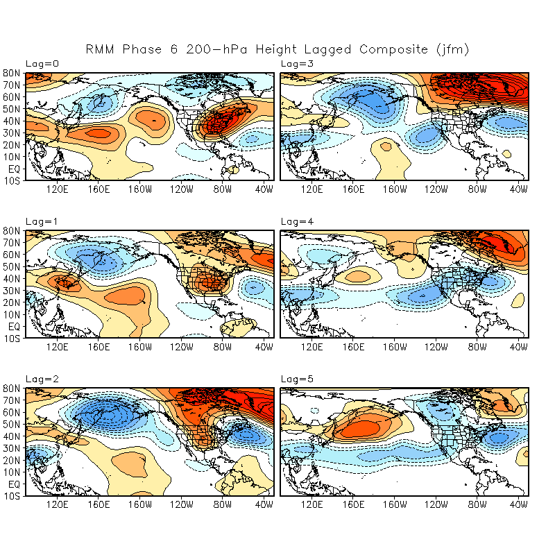
There could be a change in the longer-term pattern if the GFS is on to something. It is now forecasting a stronger MJO signal to emerge in the 10-15 day range (image below) as it moves it strongly into phase 6. Lagged composites suggest a more favorable wet pattern with an undercutting jet possibly forming in the following few weeks, meaning late February or early March.
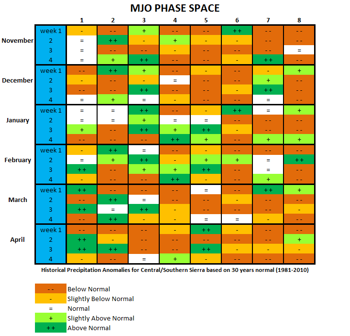
However, the other models including the ECM are not showing that solution and keep the MJO signal weak and in phase 5. Phase 5 can be wet this time of year if the signal is strong and the atmosphere primed to take advantage of the forcing (meaning there is not a strong opposing signal). Historically, a strong MJO signal during week 3 in February can be wet (two images below). We don’t have that yet, but I suspect the second half of February will be more fruitful. WG


