Powder Forecast –Tuesday, March 10th, 2020
Ted Schlaepfer CCM —- Mammoth Mountain WeatherGuy
Snowfall forecasts are valid at the Sesame snow course (Main Lodge) for the prior 24 hours as reported in the 6-7 AM morning snow report.
Wed 3/11 = 0 – 1” Thu 3/12 = 1 – 2” Fri 3/13 = 0 – 1” Sat 3/14 = 1 – 2” Sun 3/15 = 6 – 9” Mon 3/16 = 9 – 15” Tue 3/17 = 6 – 12” Wed – Fri 3/18 – 3/20 = 0 – 6”
March Snowfall = 11” March Forecast = 50 – 70″
Detailed 4-day Snowfall Forecast:
Wed 3/11—Light snowfall is possible during the day and through the evening hours. Light accumulations possible by Thursday AM of an inch or two
Thu 3/12—No snowfall expected except for a possible afternoon flurry.
Fri 3/13—Dry during the day, then there is a chance for light snowfall overnight. Light accumulations possible by Saturday AM of an inch or two
Sat 3/14—Snow showers during the day, then steady snowfall develops during the evening and overnight. Accumulation 6 – 9” by Sunday AM, 12” up top
Forecast Summary:
Short Term (Days 1 – 4):
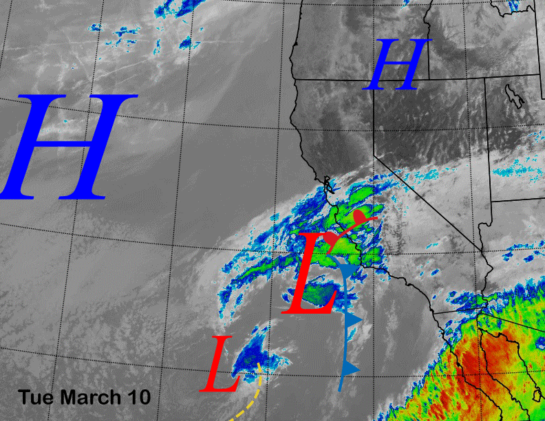
Infrared satellite imagery (below) today shows a cut-off low pressure system off the SoCal coast that is moving toward the northeast. Clouds will continue to build and snow showers are possible this evening.
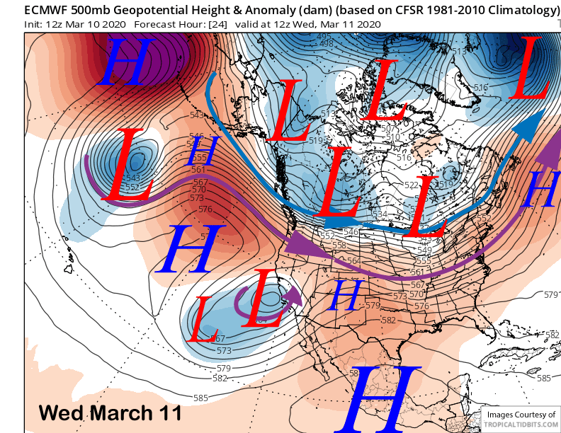
Models move the upper low onto the Central Coast early tomorrow (image below) and a band of precipitation will move toward the Sierra during the day while dissipating. This system ended up being much weaker than some models, ECM in particular, had projected it in the longer term.
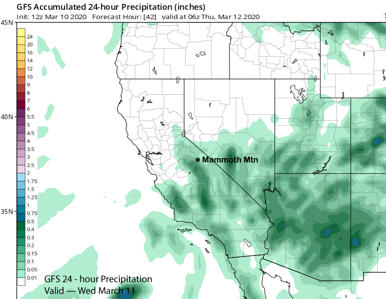
Nonetheless, light snowfall is possible tomorrow, primarily during the afternoon hours. GFS has very light amounts (image below) and under a tenth of an inch. ECM has even less. So, there could be an inch, maybe two, but not any significant snowfall. Dust on crust if there is any accumulation.
The low-pressure system moves into Baja on Thursday and dry weather will return to Mammoth, although there is a chance for an afternoon instability flurry. The dry weather should continue Friday during the day as Mammoth is in between weather systems as models are showing a high latitude type system moving around a strong high-pressure ridge in the Gulf of Alaska and the old one now moving into Arizona. Looks like the Canadian model was somewhat right on the last update.
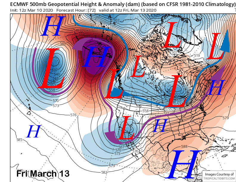
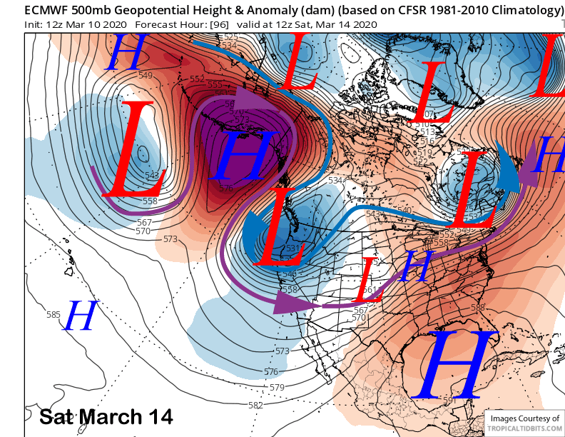
That second system will deepen quickly off the NorCal coast Saturday (image below) and moist up-slope southwest flow should start overnight Friday and increase Saturday. Those snow showers will turn into steady moderate to heavy snowfall overnight Saturday and into Sunday.
Long Range (Days 5+):
Beggars can’t be choosers. And that is what we are dealing with as we need base type snowfall to extend the season, but we are going to get cold dry powder instead, although the really dry powder might not develop until Monday. So you guys are just going to have to “suffer” with epic powder turns by early next week.
The ECM and other models are now favoring a very deep cold upper low (image below) to slowly slide southward on Sunday. That will drive a strong front through Mammoth for a period of heavy snowfall along with very strong winds. Snow levels look be around 4500 feet. Current thinking is at least a foot of snow for Main by Sunday afternoon and up to 18” up top.
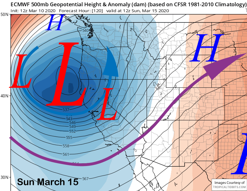
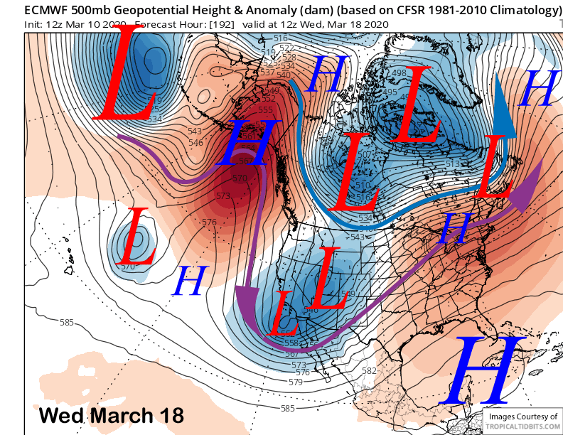
Now the models diverge a bit for early next week. The ECM model is not as progressive as the GFS and keeps the upper-low off the coast Monday (image below) while enhancing the moist southwest flow into Mammoth under lowering temperatures. The Canadian is similar to the GFS with this scenario, but the GFS model has the upper level low inland over the Central Coast by Monday AM and kills off the southwest jet stream flow into the Sierra.
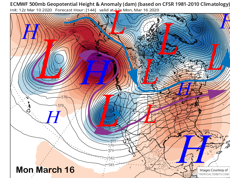
So while the GFS ends heavy snow Sunday night and into Monday with over 1.5″ liquid (image below), the ECM and Canadian models increase it significantly with another 2”+ liquid forecast for Mammoth. Snow levels would be around 4000 feet. So that could mean another two feet at Main if those models are correct. GFS scenario would only be a couple more inches of snowfall.
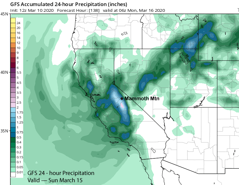
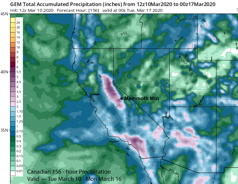
The current forecast is a broad-brush and mostly follows the ECM ensemble mean with some emphasis from the GFS. The details will change as the forecast gets closer, but overall, it looks good for powder conditions starting Sunday, maybe even by Saturday PM. ECM ensemble mean is showing about 3” liquid and about 4” over the crest. It has most of the snow falling on Sunday and Monday and continuing Tuesday. The Canadian and ECM operational runs are quite similar with the forecast liquid amounts and have about 4″ or more for Mammoth (image below).
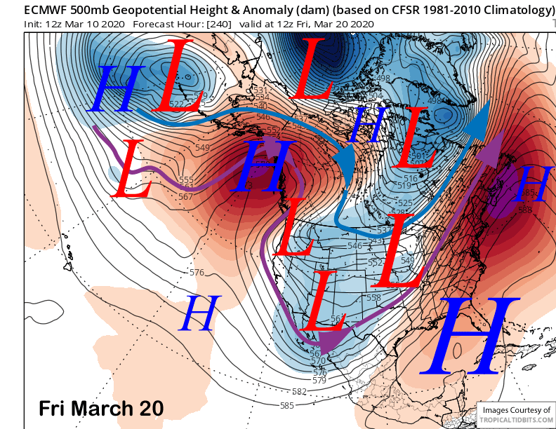
The ECM model moves the upper low eastward on next Wednesday (image below) for a return of dry weather with the continued dry weather forecast for the rest of the week. It does move another upper low into NorCal on the very back end of the pattern (two images below), but it would be an inside slider type system and mostly dry.
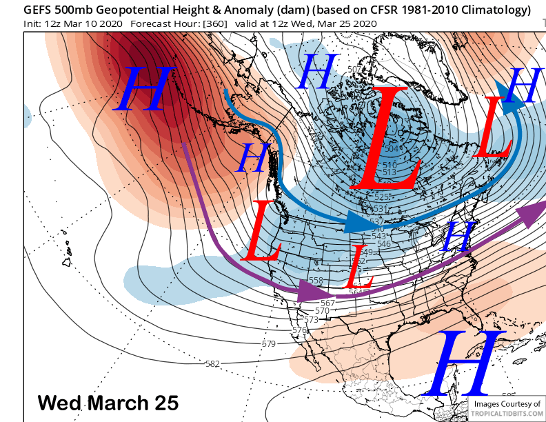
The fantasy range guidance does keep a trough along the West Coast (image below) and more weather systems may move out of the North for a chance for snow and more powder conditions. I would not be surprised to see that trough flatten out with more westerly flow as the MJO will be moving into favorable precipitation phases 2 and 3 by then. Hopefully, that will mean base snow for an extended season. WG


