Powder Forecast – Tuesday, November 17th, 2020
Ted Schlaepfer CCM —- Mammoth Mountain WeatherGuy
Snowfall forecasts are valid at the Sesame snow course (Main Lodge) for the prior 24 hours as reported in the 6-7 AM morning snow report.
**Snowfall forecast confidence ranges from very low (1) to very high (5)
Wed 11/18 = 2 – 3” (H2O = 0.30” – 0.40”) **4
Thu 11/19 = 6 – 8” (H2O = 0.60” – 0.70”) **4
Fri 11/20 = 0”
Sat 11/21 = 0”
Sun 11/22 = 0”
Mon 11/23 = 0 – 2”
Tue 11/24 = 0”
Wed – Fri 11/25– 27 = 0 – 3”
November Snowfall = 14”
November Forecast = 30 – 40”
Detailed 4-day Snowfall Forecast:
Wed 11/18 — Heavy snow is expected during the morning hours before decreasing during the afternoon and then ending Wednesday night. Strong winds during the morning decrease during the afternoon. Storm accumulations 8-11” Main; 12-15” up top.
Thu 11/19 through Sat 11/21 – No snowfall expected all days except a chance for flurries or light snow showers Friday.
Forecast Summary:
Short Term (Days 1 – 4):
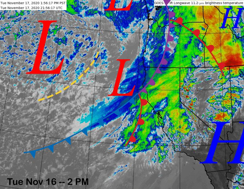
The afternoon satellite image (below) shows a storm system currently moving into Central and Northern California with low-elevation rain and higher elevation mountain snowfall above 8000 feet. The weather system will continue to move south and eastward over the next 24-hours with the front expected to move into Mammoth early tomorrow.
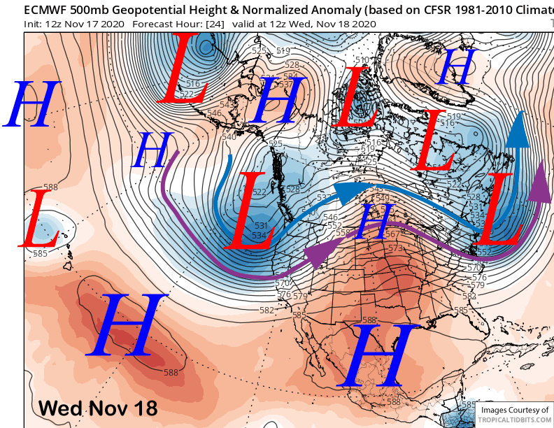
The front will be driven by a rather deep upper level trough that is forecast to move inland early Wednesday (image below). Snow should begin before dawn and become heavy during the early and mid-morning hours before decreasing midday and into the afternoon, then ending Wednesday night. Winds will also be gusty during the morning before decreasing during the afternoon.
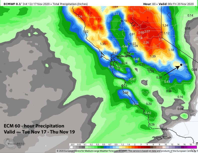
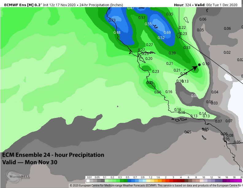
The 12Z run of the ECM model is showing about an inch of liquid over Mammoth with the passage of the storm system (image below) that should equate to about 8-10” of snow at Main and over foot up top. This is not a cold storm with snow levels around 7-7500 feet for the peak of the event resulting in base-type Sierra cement. Snow ends Wednesday night followed by a partly cloudy day Thursday.
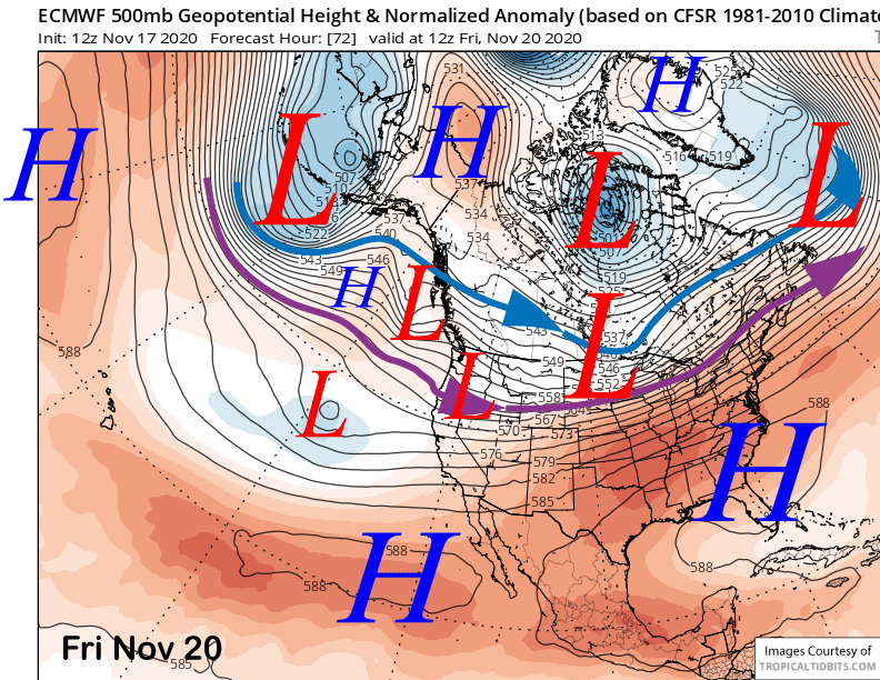
Weak split jet stream zonal flow is then forecast for the remainder of the week with a weak short-wave possibly moving through the Sierra Friday (image below). GFS is stronger with this feature and produces light snow while all the ECM ensemble members are dry. It will probably be just an increase in wind Friday, clouds, and maybe some flurries.
Long Range (Days 5+):
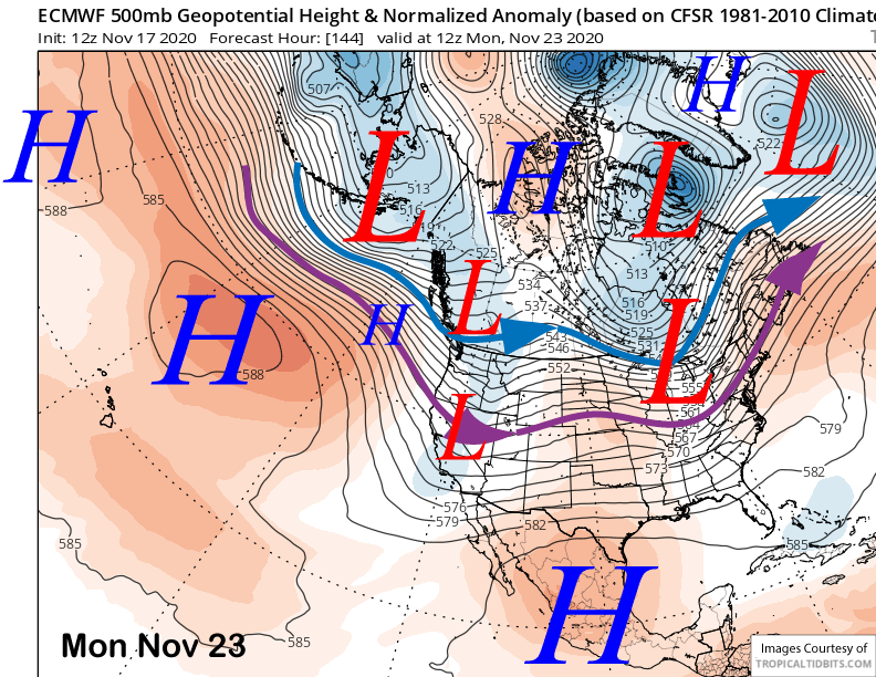
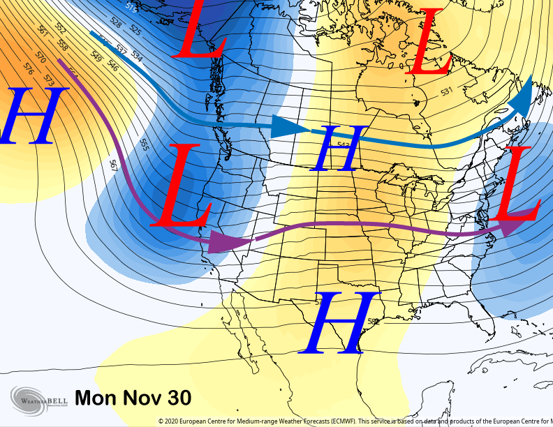
The longer-range guidance has generally trended drier over the past many days/runs after showing some potential storms for next week. The latest ECM run now just moves an innocent short wave trough in split jet stream flow through eastern CA around Monday (image below) next week for only a chance for light snow showers and more likely just gusty winds.
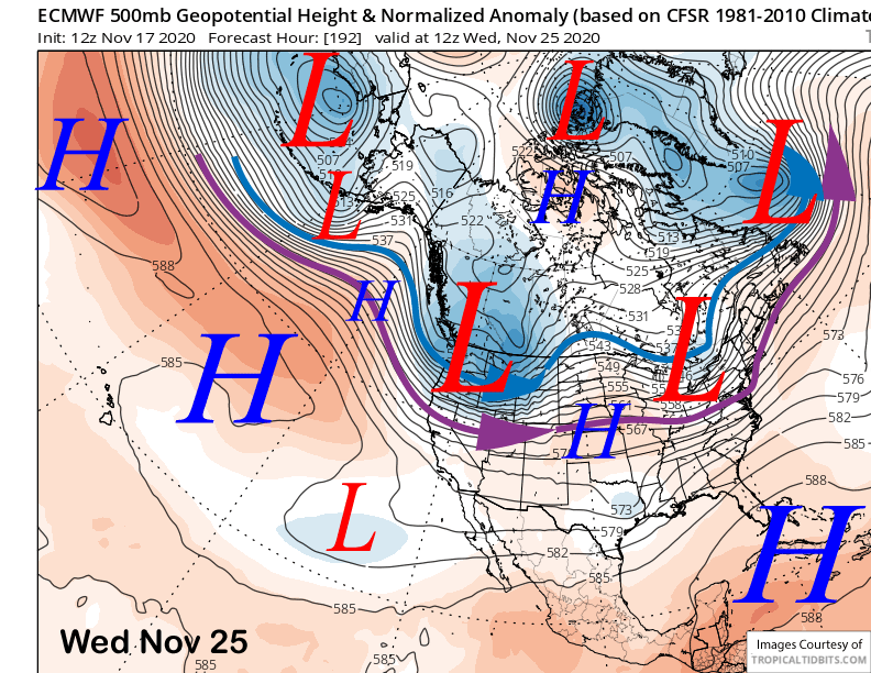
That model moves a stronger one through the PacNW around the middle part of next week (image below) that will be too far north for any significant snowfall in Mammoth with that solution, although a couple inches would not be out of the question. The GFS model is similar to the ECM while the Canadian model is farther north and eastward with the trough.
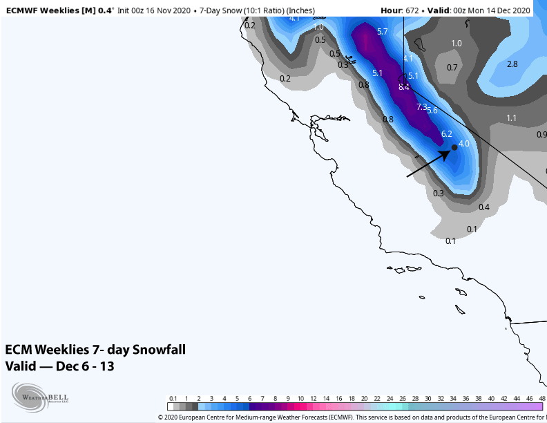
The next decent chance according the ECM ensemble for any significant snowfall would be toward the end of the month. That model favors a West Coast long-wave trough (image below) that extends southward into CA allowing storm systems to move into CA and Mammoth.
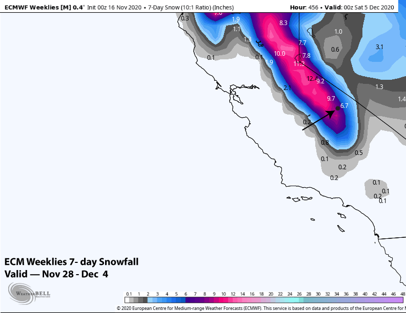
The ensemble is not bullish on a big event as it is not showing large amounts right now (image below) with the 7-day snowfall forecast also less than a foot. (two images below). Overall, let’s hope this chance doesn’t disappear in future runs like the previous chances did.
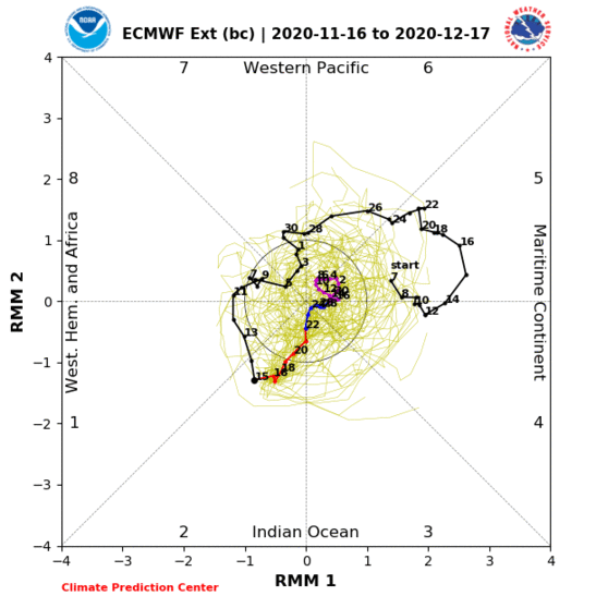
The super fantasy guidance does keep some snowfall in the forecast into the second week of December (image below) before favoring a dry period mid-December. The MJO is forecast to be in phase 5 by then as a low-amplitude standing wave (two images below). Unfortunately, that often results in dry weather for CA.