Powder Forecast – Saturday January 2nd, 2021
Ted Schlaepfer CCM —- Mammoth Mountain WeatherGuy
Snowfall forecasts are valid at the Sesame snow course (Main Lodge) for the prior 24 hours as reported in the 6-7 AM morning snow report.
**Snowfall forecast confidence ranges from very low (1) to very high (5)
Sun 1/3 = 0”
Mon 1/4 = 0 – 1”
Tue 1/5 = 6 – 9” (H2O = 0.75” – 1.00”)**3
Wed 1/6 = 0”
Thu 1/7 = 0 – 1”
Fri 1/8 = 0”
Sat 1/9 = 0 – 6”
Sun – Tue 1/10 – 1/2 = 0”
January Snowfall = 0”
January Forecast = 35 – 50”
Detailed 4-day Snowfall Forecast:
Sun 1/3 – No snowfall expected.
Mon 1/4 –Light snowfall is possible by early morning, otherwise a period of moderate/heavy snowfall is expected mid-afternoon and through the evening hours before ending at night. Accumulations 6 – 9” by Tuesday AM, ~10″ up top.
Tue 1/5 and Wed 1/6 – No snowfall expected both days other than flurries Wednesday afternoon and evening
Forecast Summary:
Short Term (Days 1 – 4):
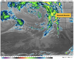
The infrared satellite image (below) this morning shows lots of cloudiness moving into CA off the Pacific, but only light rain showers for the central and northern California coastal areas. The low-pressure system associated with the clouds will move eastward into the Pacific NW with the southern edge moving into NorCal where the rain will stay, leaving Mammoth dry.
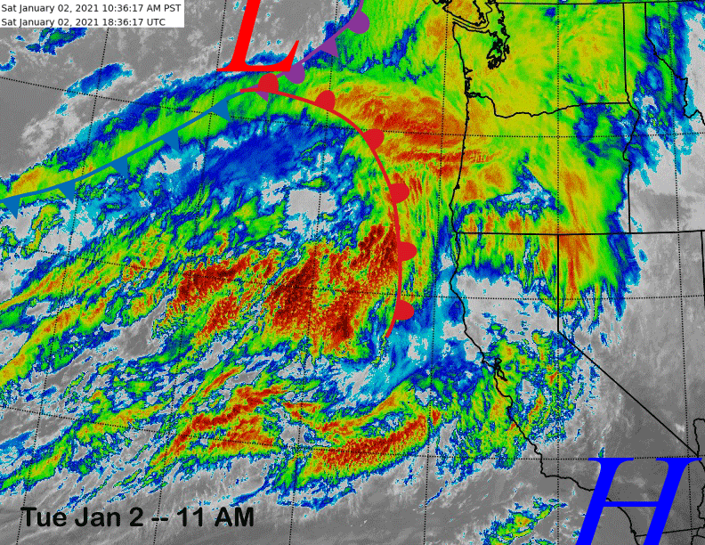
The next upstream for Monday (image below) is going to have a much better chance of producing snowfall in Mammoth as the models are in reasonable agreement that the southern edge of the jet stream will move far enough southward.

There may be some upslope orographic snowfall early Monday, otherwise all of the snowfall will occur with the passage of the front Monday afternoon and evening before ending at night. Snow levels will be around 6000 feet for the event and it will be base-type snowfall.
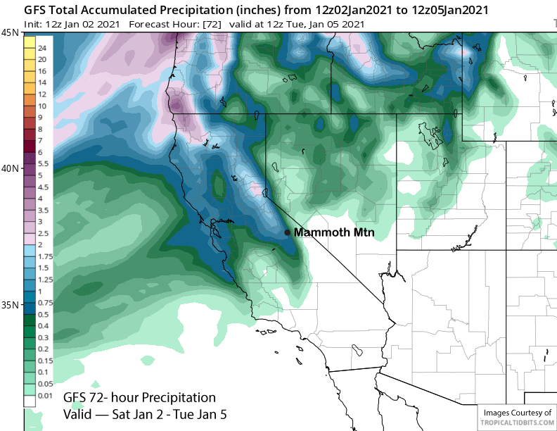
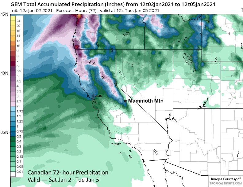
GFS model (image below) is fairly similar to the ECM model with about 0.75” while the Canadian model (two images below) is drier with around 0.50” liquid. Overall, it looks like a solid 6” at Main and around 10” up top and likely enough for powder turns Tuesday morning.
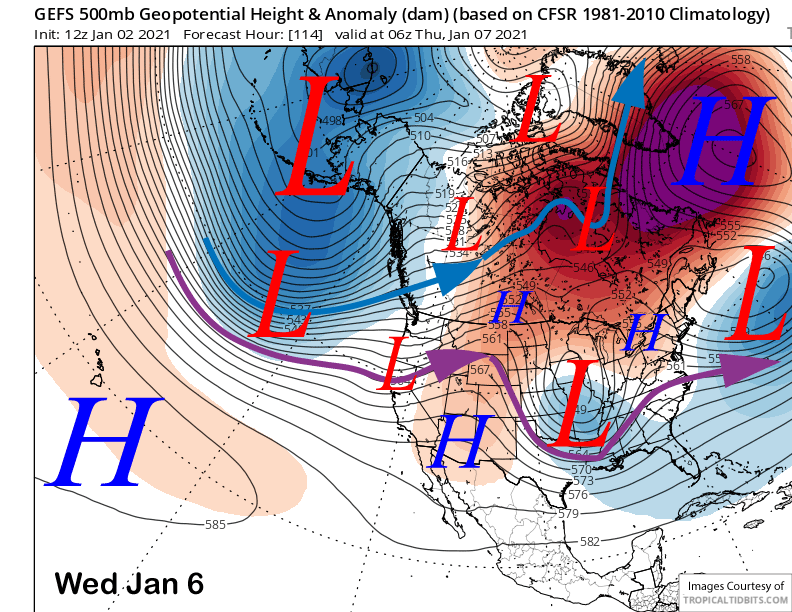
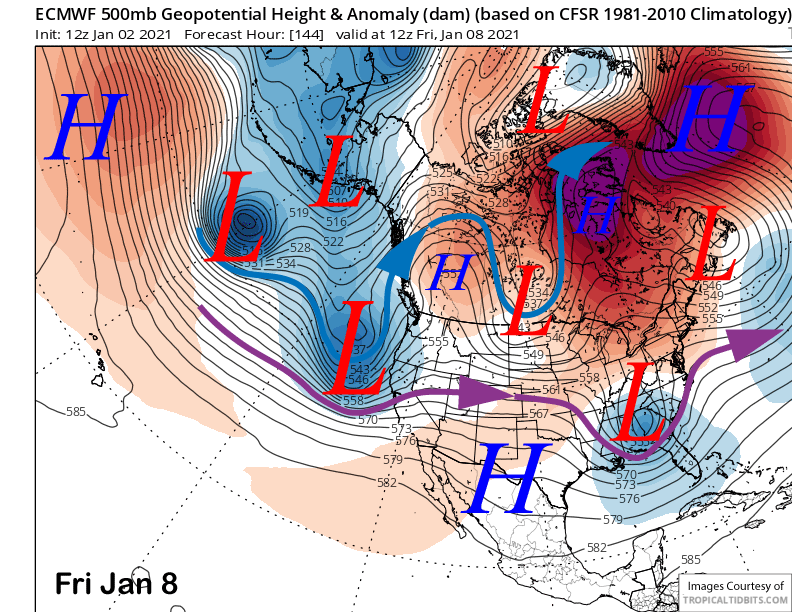
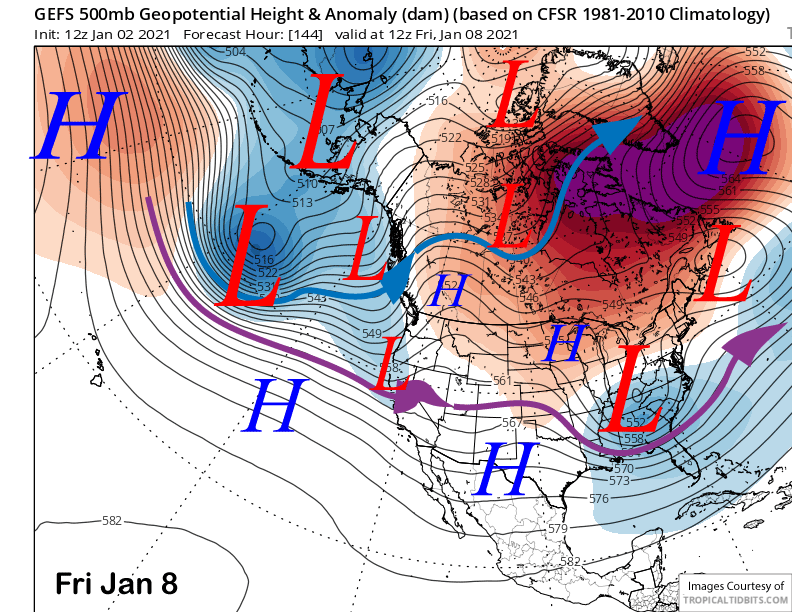
Tuesday is expected to be a dry day as Mammoth will be in between systems with the next system now expected to be much weaker than previously forecast and also farther northward per the GFS ensemble mean (image below). The latest ECM run is also farther northward and all the models are now showing no snowfall for Mammoth through mid-week other than a chance for flurries Wednesday afternoon and evening.
Long Range (Days 5+):
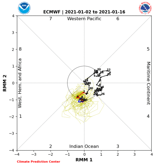
So what happened to the favorable pattern change? It looks like MJO activity (image below) will now emerge farther westward in phase 2 as opposed to the more favorable phase 3 in addition to being a weaker signal overall. Thus, the potential boost to strengthen the Pacific jet stream into the West coast and CA will not happen now. Models are just not that good beyond 7 days with accuracy really confined to just under 4-5 days.
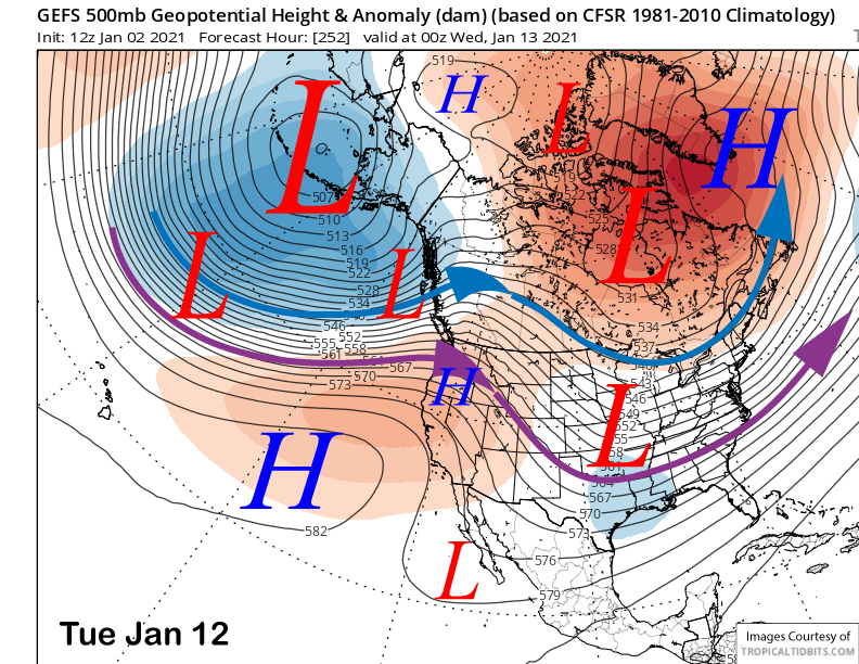
The latest ECM model does move a moderately strong trough into CA around next Friday (image below) and just beyond that range of good predictability. It has close to a foot of snow for Mammoth. However, the other deterministic models are farther northward, although the GFS ensemble mean (two images below) has the trough far enough southward, but it weaker, as it splits the system upon landfall. So best forecast right now would be for a few inches end of next week, but also a chance for nothing.
Beyond Friday, the numerical guidance is in general agreement that the jet stream will lift northward and ridging will develop along the West Coast (image below) as the long-wave trough near the Aleutians retrogrades westward. There could be some flurries Sunday with one last wave moving in the westerly flow across NorCal, otherwise dry weather is favored to return after the 10th and continue through mid-January.
Beyond mid-January, the climate models are mixed. The latest CFS model has precipitation returning by the 3rd week of January while the ECM model is basically dry until February. It looks like the MJO signal will remain weak and not influence the pattern rest of January. Hopefully something will change as the outlook is looking bleak.
There is something going on in the polar regions that may influence the pattern, but not in the short term. A SSW (Sudden Stratospheric Warming) event is currently unfolding that is projected to continue for the next month or so. A SSW is when the stratospheric vortex that forms every winter and dissipates every spring suddenly becomes disrupted and much weaker than normal that causes the lower stratosphere to warm considerably. If it couples with the troposphere, then that warming can be displaced downward causing North Pole temperatures to increase rapidly.
That jump in temperatures across the North Pole is called a Major Mid-winter Warming (MMW) event and leads to strong high pressure and a negative Arctic Oscillation. That can lead to the circumpolar jet stream to move farther southward than normal resulting in strong cold outbreaks across the mid-latitudes, although not all MMWs have a robust influence on the weather. Further, MMWs influence on the weather is often much weaker when the QPB is in the westerly phase as it is this winter.
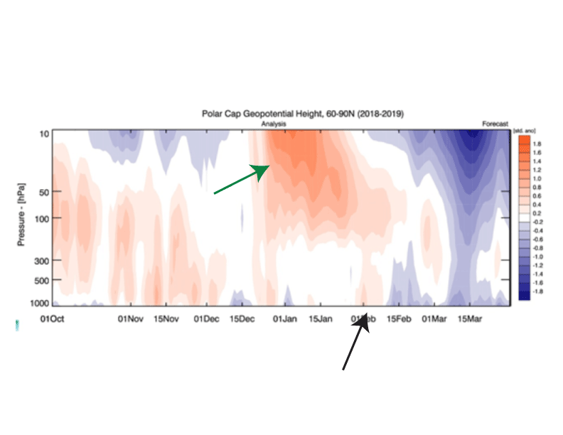
There have been instances where the SSW and MMW led to big snowfall for Mammoth, February 2019 is the latest example from a SSW that started on January 2nd. However, that SSW (image below- green arrow) was considered a non-classical response and not even robust as there was only one “drip” or coupling into the lower troposphere about a month later (black arrow). These couplings usually take 3-6 weeks to occur after the start of the event, so any direct effects from this event won’t happen until the end of January or early February.
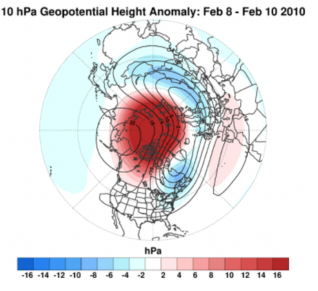
Right now, tropospheric coupling is expected with the SSW and the MMW is projected to resemble the event from February 2010 (image below). That event resulted in severe cold for Europe and a bout of cold for the MidWest/South. However, it did not lead to increased snowfall for Mammoth as March that season had the lowest total for all the months December through April including a two-week dry spell. 2009-10 was also a big year, unlike this season. So hopefully will get a favorable response this time. Time will tell. WG