Powder Forecast – Friday January 22nd, 2021
Ted Schlaepfer CCM —- Mammoth Mountain WeatherGuy
Snowfall forecasts are valid at the Sesame snow course (Main Lodge) for the prior 24 hours as reported in the 6-7 AM morning snow report.
**Snowfall forecast confidence ranges from very low (1) to very high (5)
Updated 1/25 @ 1200
Sat 1/23 =2”
Sun 1/24 = 1”
Mon 1/25 = 6” (H2O = 0.30”) **3
Tue 1/26 = 2 – 3” (H2O = 0.10” – 0.15”) **3
Wed 1/27 = 10 – 12” (H2O = 1.00” – 1.25”) **4
Thu 1/28 = 36 – 44” (H2O = 4.00” – 4.50”) **4
Fri 1/29 = 26 – 34” (H2O = 3.00” – 4.00”) **3
Sat – Mon 1/30 – 2/1 = 12 – 20”
January Snowfall = 11”
January Forecast = 80 – 100”
Detailed 4-day Snowfall Forecast:
Sat 1/23 – Likely dry during the morning and early afternoon or just flurries, then light snow develops during the afternoon and evening, tapering off overnight. Accumulations 2 – 3” by Sunday AM and 3”+ up top
Sun 1/24 – Dry during the day with increasing clouds during the afternoon, then snow develops overnight. Accumulations 2 – 3” by Monday AM and 4”+ up top
Mon 1/25 –Light to moderate snow during the day and through the evening hours, tapering off overnight. Accumulations 5– 7” by Tuesday AM and 10”+ up top
Tue 1/26 –Partly sunny with increasing clouds and wind late afternoon and evening leading to snow and strong winds overnight, becoming heavy by the morning. Accumulations 6 – 12” by Wednesday AM and 12”+ up top
Forecast Summary:
Short Term (Days 1 – 4):
The infrared satellite image (below) this afternoon shows a couple upper-level low pressure system along the West Coast, one centered off the CA/OR coast, and the other over the Bay Area. The one over the Bay Area will move eastward overnight and produce light to moderate snowfall for the rest of today and into tonight for Mammoth adding up to at least a few inches of fluffy snowfall. The other low-pressure system will move southward tomorrow into SoCal.
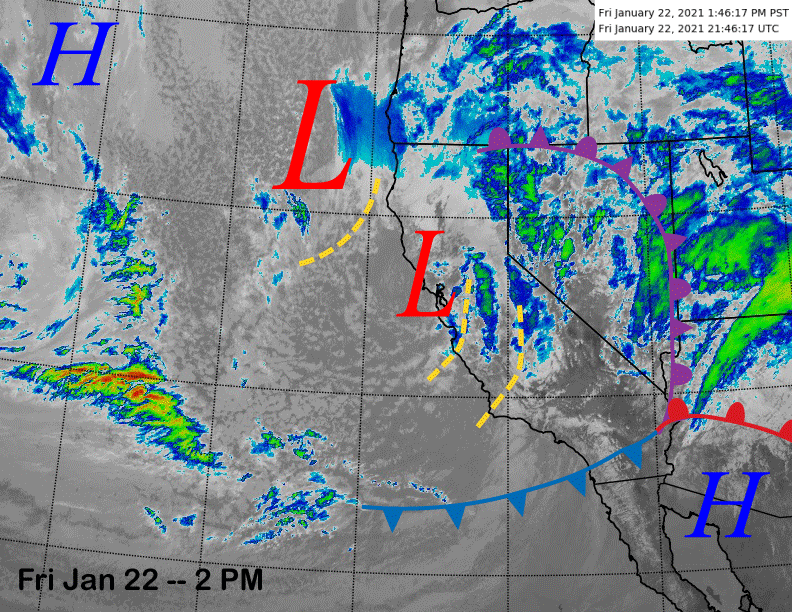
As it does so, wrap-around moisture in the northeast flow will move into the eastern Sierra during the afternoon and evening resulting in more light snowfall. It will be chilly in the moist up-slope NE flow and snow ratios will be in the 15-20:1 range. Snow will taper off Saturday night.
Sunday will be dry during the day, although extensive clouds by the afternoon will lead to low-light conditions. Those clouds are associated with the next storm (image below) that is expected to move into the Sierra and Mammoth area early Monday morning with snow expected all day and into the evening before tapering off overnight.
It isn’t exactly loaded with moisture as the models are only suggesting about 0.50” or so of liquid with the storm. However, it will be a cold storm with snow levels starting out at 3000-3500 feet before lowing to below 2000 feet Monday evening and night.
Since winds won’t be super strong to cause fracturing of the developing snow crystals, liquid to snow ratios may approach 20:1 or higher with this storm. That means there could be up to a foot of super fluffy Colorado type snow by Tuesday morning that may be a bluebird one. Remember, it is still low tide out there.
Long Range (Days 5+):
The longer-range guidance still has not changed much since the last update and that is a good thing as the transition into a more favorable pattern for significant snowfall is looking probable for the middle part of next week.
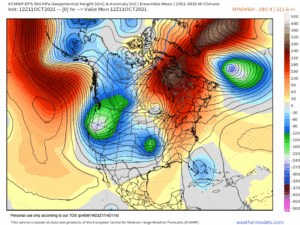
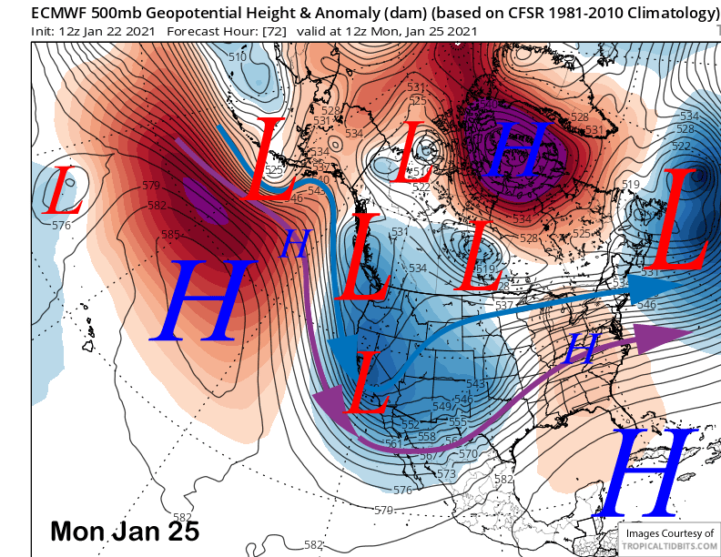
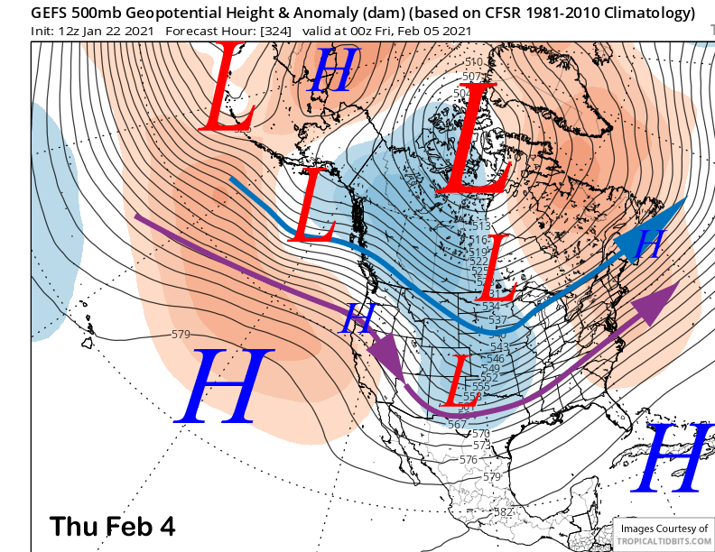
All the models are now in agreement that a very deep upper level trough will move southward along the West Coast by Wednesday next week (image below) as a strong North Pacific blocking pattern will strengthen the downstream long-wave trough over the West Coast and CA.
This appears to be a set-up for a classic Sierra snowstorm with a strong polar jet stream (blue arrow) directed into the Sierra under southwest flow. There may also be an atmospheric river (AR) embedded in the southwest flow that will provide copious amounts of moisture into the strong frontal band that will be moving slowly southward Wednesday allowing the snowfall to pile up.
Due to the cold air already in place and the lower than normal geopotential height, snow levels will be lower than normal with an AR and in the 4-5000’ range. The strong jet stream will also mean good spill-over into the adjacent eastern valleys with heavy snow also possible in Bishop and the upper Owens Valley where snow levels will be slightly lower.
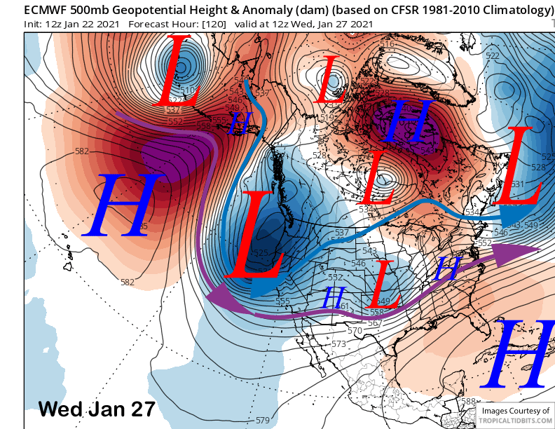
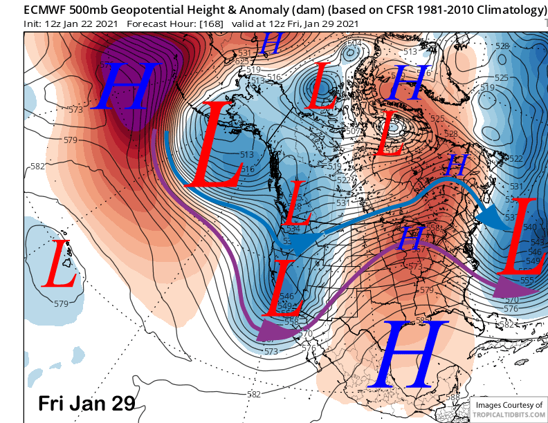
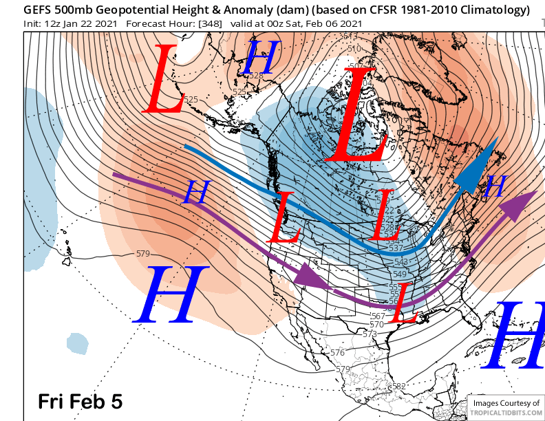
Snowfall may continue at time Thursday as the models don’t move the trough axis out of CA until Friday (image below), but right now, it looks like the blizzard conditions will occur on Wednesday during the day and Wednesday night. I would not be surprised if the mountain shuts down completely on Wednesday with a slow opening on Thursday.
The models QPF right now is in the 5-6” liquid range for the two days that makes it a very good storm, but not historical. Due to the strong winds, there will likely be snow crystal fracturing and ratios probably in the 8-10”:1” range. That means 3-4 feet of snow for Main is looking good right now and maybe up to five feet if we get lucky. The top will probably get 5-7 feet with the southwest winds piling the snow up in the upper bowls.
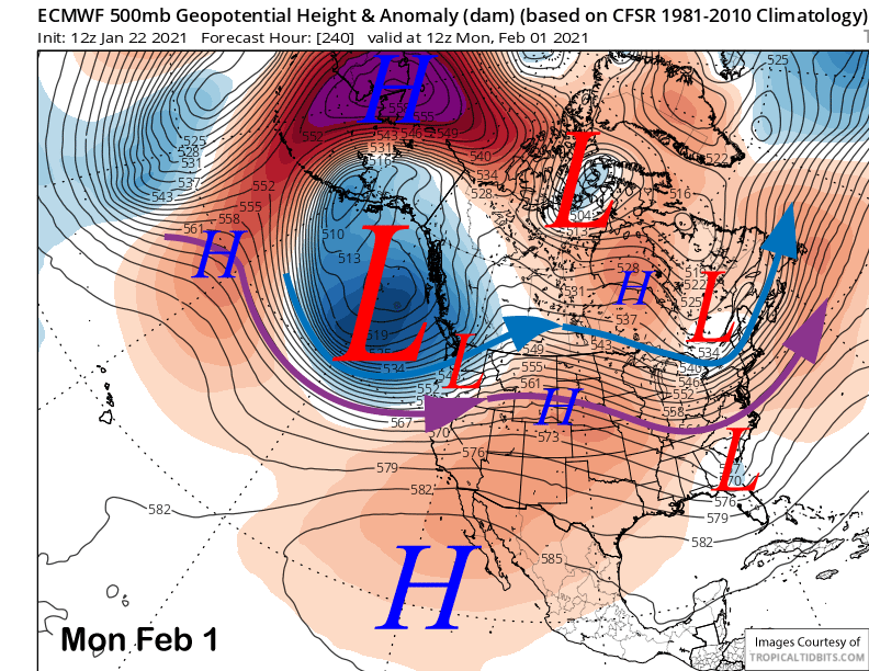
The storm should end Friday followed by a break into Saturday. Models are then suggesting another chance for snowfall by Sunday and/or into the following week, although they did diverge on the 12Z runs this morning. The ECM now keeps the next system farther northward (image below) as it is weaker with the North Pacific block and stronger with the Bering Sea block that would result in the down-stream trough at a higher latitude.
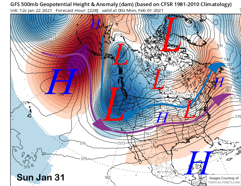
The Canadian is farther south than the ECM, but weaker with the overall upper level low as splits the strength equally between the N. Pacific block and Bering sea one. The GFS has the most favorable solution (image below) as it favors a stronger N. Pacific block and weaker Bering sea block resulting in the downstream trough farther southward.
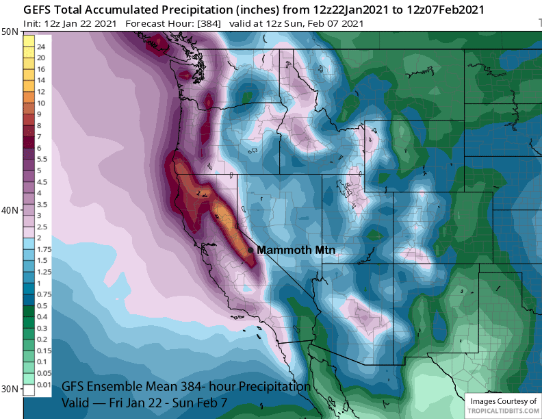
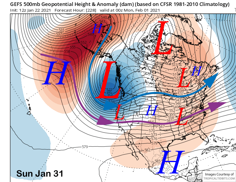
Current forecast leans toward the GFS solution as the GFS ensemble mean (image below) has the jet stream far enough southward for the precipitation to move into the Mammoth Area. Let’s hope it does, as there could be another AR embedded in the westerly flow that could result in another big storm. The forecast doesn’t go all in yet due to the uncertainty and the fact that it is still 8-9 days out, but a foot or more is certainly possible.
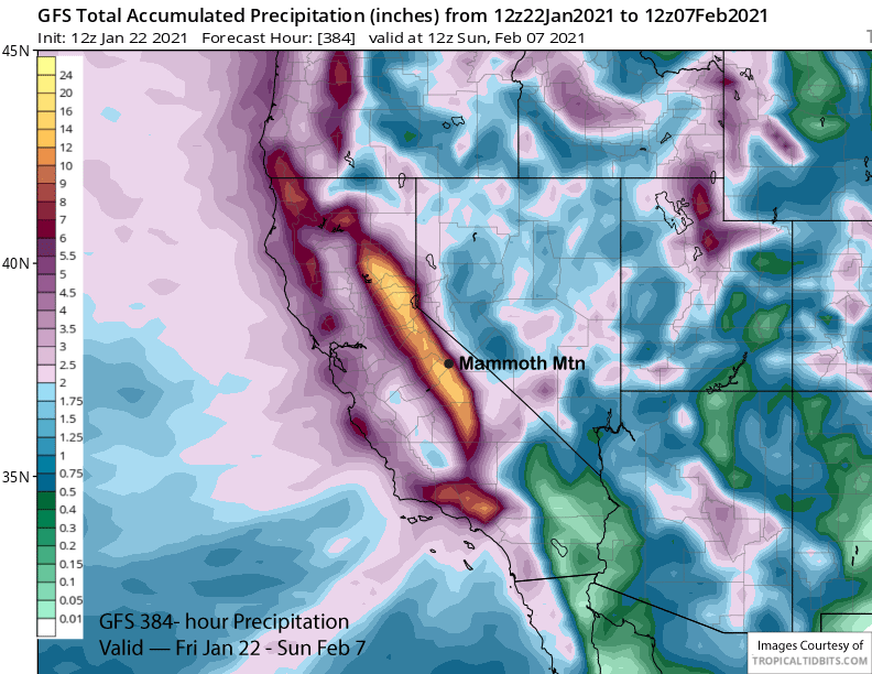
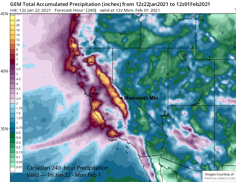
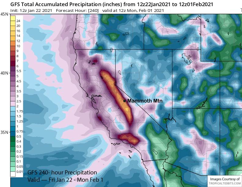
The model QPF for the 10-day period is fairly impressive with the Canadian (image below) having about 16″ west of the crest while the GFS is showing about 10″ (two images below). Last night’s run of the ECM had 10″ for Mammoth before the 12z run moved the last storm northward and it backed off to around 5″. The ECM mean has over 6″ liquid for the period.
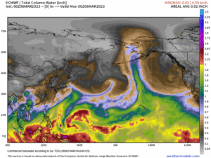
It does look like the storm pattern will come to an end by the middle part of the following week as high pressure will likely build back into CA (image below). The ensemble mean does suggest a system may move into NorCal and the PacNW around that Friday (two images below), but probably too far north for significant snowfall in Mammoth. The ECM climate model does suggest storms may return mid-February.
Overall, it finally looks like we get our turn with a major storm next week with total QPF for the period looking impressive on both the GFS operational model (image below) at around 12” liquid and ensemble mean (two images below) at around 8”. It should be enough to open up most of the top and likely extend the season to Memorial Day. Woot! WG