Powder Forecast – Friday February 12th, 2021
Ted Schlaepfer CCM —- Mammoth Mountain WeatherGuy
Snowfall forecasts are valid at the Sesame snow course (Main Lodge) for the prior 24 hours as reported in the 6-7 AM morning snow report.
**Snowfall forecast confidence ranges from very low (1) to very high (5)
Sat 2/13 = 1 – 2” (H20 = 0.10” – 0.20”)**4
Sun 2/14 = 3 – 4” (H20 = 0.30” – 0.40”)**4
Mon 2/15 = 0”
Tue 2/16 = 2 – 4” (H20 = 0.25” – 0.35”)**2
Wed 2/17 = 0”
Thu 2/18 = 0”
Fri 2/19 = 0 – 4”
Sat – Mon 2/20 – 2/22 = 2 – 6”
February Snowfall = 15.5”
February Forecast = 30 – 40”
Detailed 4-day Snowfall Forecast:
Sat 2/13 – Light to moderate snowfall is expected during the day, ending during the evening. Accumulations 3 – 4” by Sunday AM, ~6” up top.
Sun 2/14 – No snowfall expected.
Mon 2/15 – Light to moderate snowfall is expected during the day, ending late evening. Accumulations 2 – 4” by Sunday AM, up to 6” up top.
Tue 2/16 – No snowfall expected.
Forecast Summary:
Short Term (Days 1 – 4):
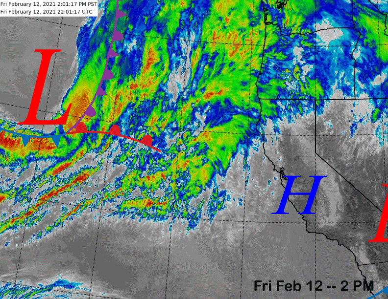
The infrared satellite image (below) this afternoon shows a transitory ridge of high pressure has build into California in the wake of the weather system that moved through overnight with 15-18” of snowfall. The next weather system is now entering the eastern Pacific and will move into the state tomorrow.
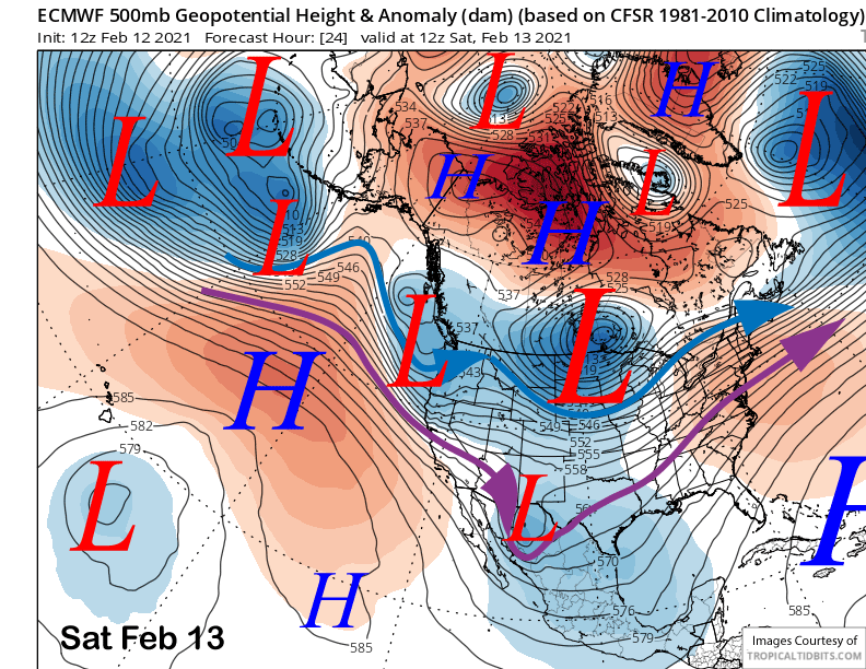
The system will be moving into CA tomorrow (image below) under northwest jet stream flow that is not the best alignment for heavy snowfall in Mammoth as orographic effects (flow against a barrier) will be minimalized since the jet will be coming in at an angle to the Sierra.
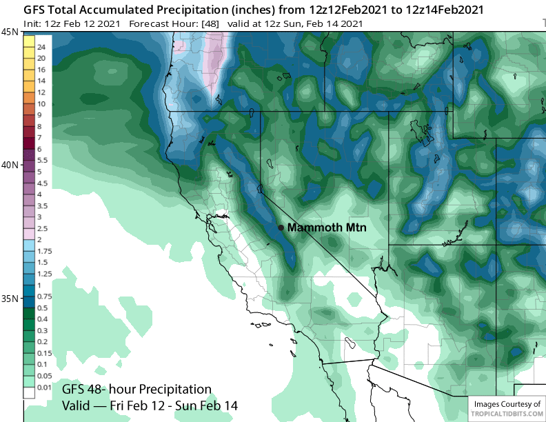
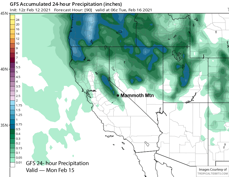
Nonetheless, the system does have a decent amount of moisture and the weak frontal dynamics are forecast by the models to squeeze out about a half inch of liquid (image below). Snowfall may start late tonight followed by a brief break in the morning with most of the snowfall falling during operating hours (riders of the storm!) before ending during the evening.
A solid few inches is expected with about 6” up top and should be a good refresher to the snowfall that just fell. Snow levels will start out around 6000 feet before lowering to 4000 feet tomorrow night as the snowfall is ending. The snow quality should be similar to the last storm.
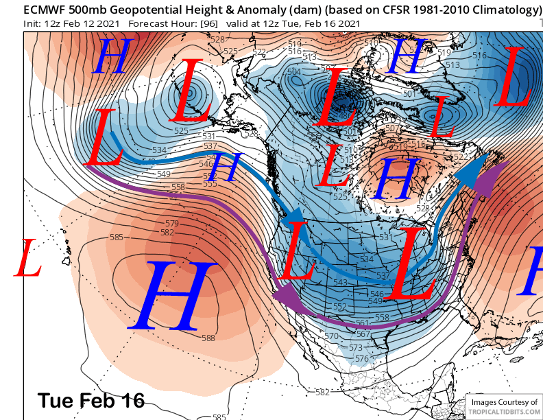
Sunday will be a dry day, then on Monday the next weather system will take a similar path under northwest jet stream flow as the Saturday storm (image below). It will have a decent amount of moisture to squeeze out as well as the precipitable warm plume will have over an inch of liquid to work with.
However, since the orographic effects will be weak again, only light to moderate snowfall is expected from the storm during the day Monday and into Monday evening with the snowfall forecast to end overnight. GFS (image below) with about a 0.35” is not as wet as the ECM that has about 0.50” for the event.
So another couple to a few inches is likely for very low-end powder conditions by late Monday and Tuesday, but probably not deep powder. Tuesday should be a bluebird day with chilly winter-like temperatures. There should be some really fun turns out there.
Long Range (Days 5+):
The longer-range guidance is still suggesting another chance for snowfall toward the end of next week after another brief break through Wednesday. How much snowfall though, is still a big question mark.
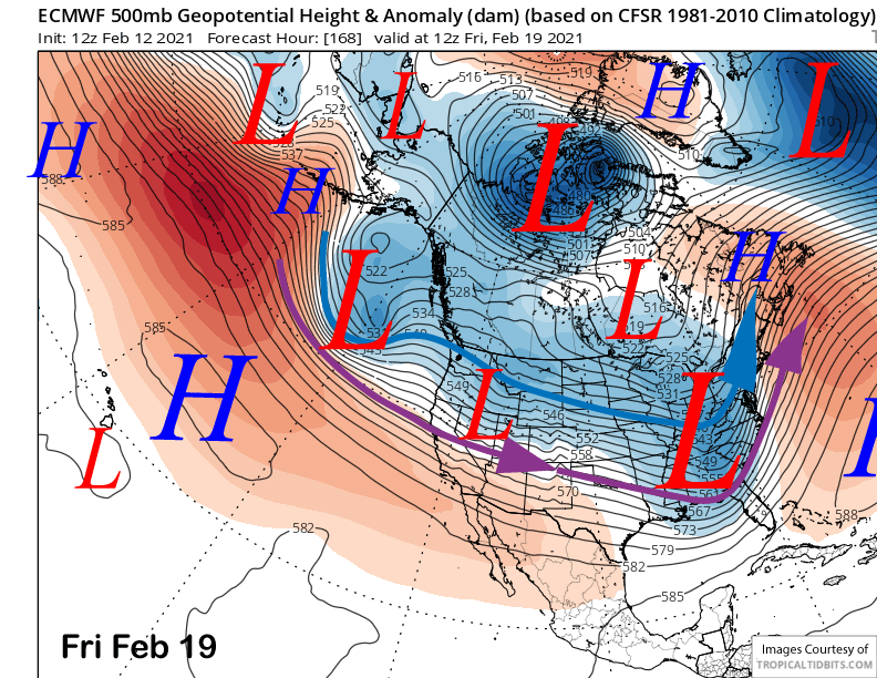
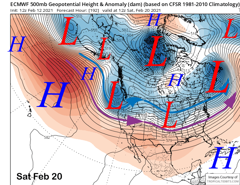
The ECM model moves a system into CA in zonal flow on Thursday and into Friday (image below) and has the jet stream (purple arrow) far enough southward for some light to moderate snowfall for Mammoth. Then is has a trailing trough move into the state Saturday (image below) that may produce more light snowfall as that system appears to be moisture starved.
The GFS model does not have the Thursday wave, but instead, moves a trough into CA on Friday and into Saturday with the tail end brushing Mammoth with light snowfall. This is backed by the ECM ensemble mean (image below) that has the trough passage on Friday too with the jet barely far enough southward for some snowfall for Mammoth.

The Canadian model has the end of the week storm too and is the strongest as it digs the trough farther southward off the coast before landfall. A few of the ECM solutions are showing this as well. But right now, it is an outlier solution.
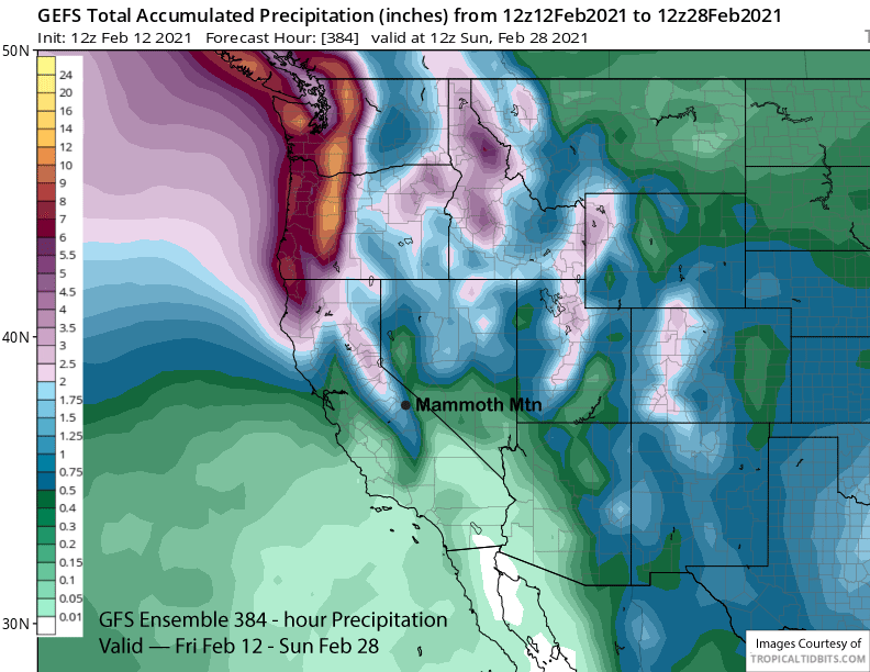
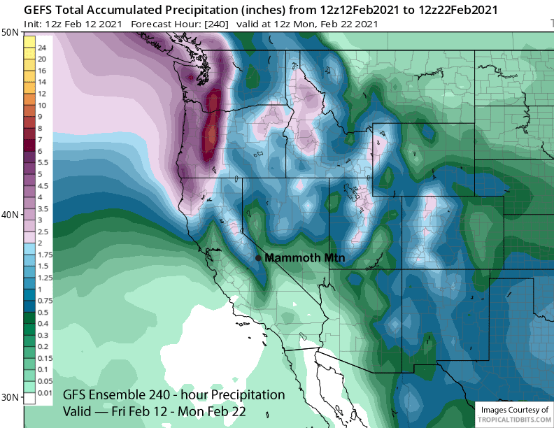
Currently, the forecast is only favoring small amounts of snowfall for the end of next week. The ECM ensemble mean is not showing a lot of liquid (about an inch) for the 10-day period (image below) and confidence in the wetter solutions is low as a result.
The GFS ensemble mean is then favoring dry weather to return late over that weekend and into the early part of the following week (image below) with high pressure building into the state as the long-wave trough shifts eastward into mid-section of the country.
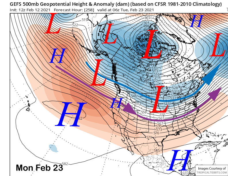
The dry weather may last through mid-week before the fantasy range guidance is suggesting that the long-wave trough will start to undergo discontinuous retrogression westward back over the West Coast over the last part of the month (images below). That may continue into early March as being suggested by the latest ECM climate maps that are also showing a productive March as a whole.

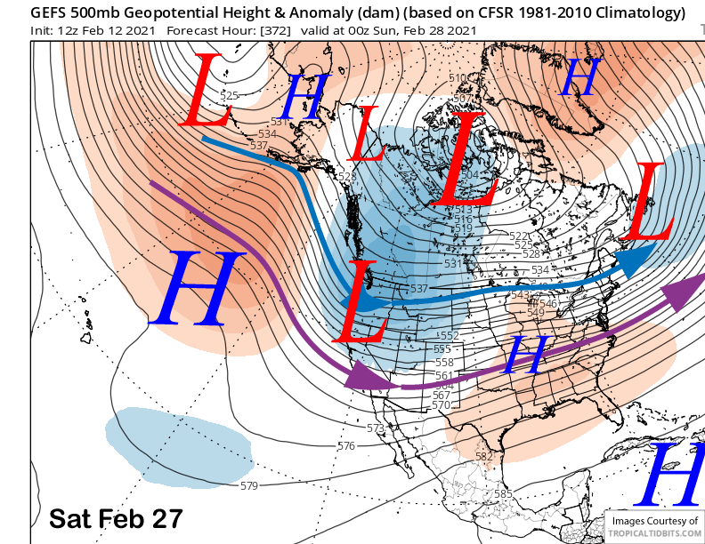
Overall, there will probably be a few days break before snowfall chances and potential powder days return toward the end of the month and into early March. In the meantime, these small storms will help to keep conditions prime for the next week or longer. WG