Good morning it’s Tuesday, June 1st, 2021 @ 7:49 AM Hello, and thanks for stopping by my Weather Forecast Center.
FYI: from here on out I will be updating this weather center page at least every other day all year long. Next update will be at 5 PM on Thursday…!
When we get into periods of Winter Storms or Summer Thunder Storms I will update daily.
This weather page has a new URL from the old page so take note of it… mammothsnowman.com/mammoth-mountain-eastern-sierra-weather-forecast
Today’s windowcast is showing clear blue beautiful skies from Mammoth Lakes to June Lakes and down to Bishop.
Checking in on current conditions this morning, at the top of Mammoth Mountain (11,053 Feet) the temperature is 49 with an ENE wind at a steady 15 MPH. At the Main Lodge and up in the Mammoth Lakes Basin the temperature is a balmy 58.
Down in Mammoth Lakes, the temperature is 57 with calm winds. In Crowley Lake, the temperature is 58, and down in the Bishop / Round Valley areas the temperature is at 66.
These are by far the warmest morning temperatures we have seen so far in 2021.
Forecast for the Eastern High Sierra from Bishop to Mammoth Lakes and over the Inyo Forest High Country
For Mammoth Mountain at Main Lodge and the Mammoth Lakes Basin (at the 8900-foot level). Highs will be in the low to mid-70s with nighttime lows in the upper 40s to low 50s through Saturday.
Mammoth Lakes (at the 7900-foot level) will be in the upper 70s to the low 80s with lows in the upper 40s to low 50s.
For Crowley Lake and Long Valley (at the 7000-foot level) highs will be in the mid-80s with night times lows in the low to mid-50s.
Down in Bishop and Round Valley highs will be in the mid-90s. Looks like they will miss hitting the century mark at this point.
Wind Forecast
Over the next few days expect Southwest winds 10 to 15 mph at times, with possible gusts up to 25 mph. Higher elevations and the sierra crest will have gusts at times up to 35 MPH.
Current Weather Summary and 10 Day Outlook
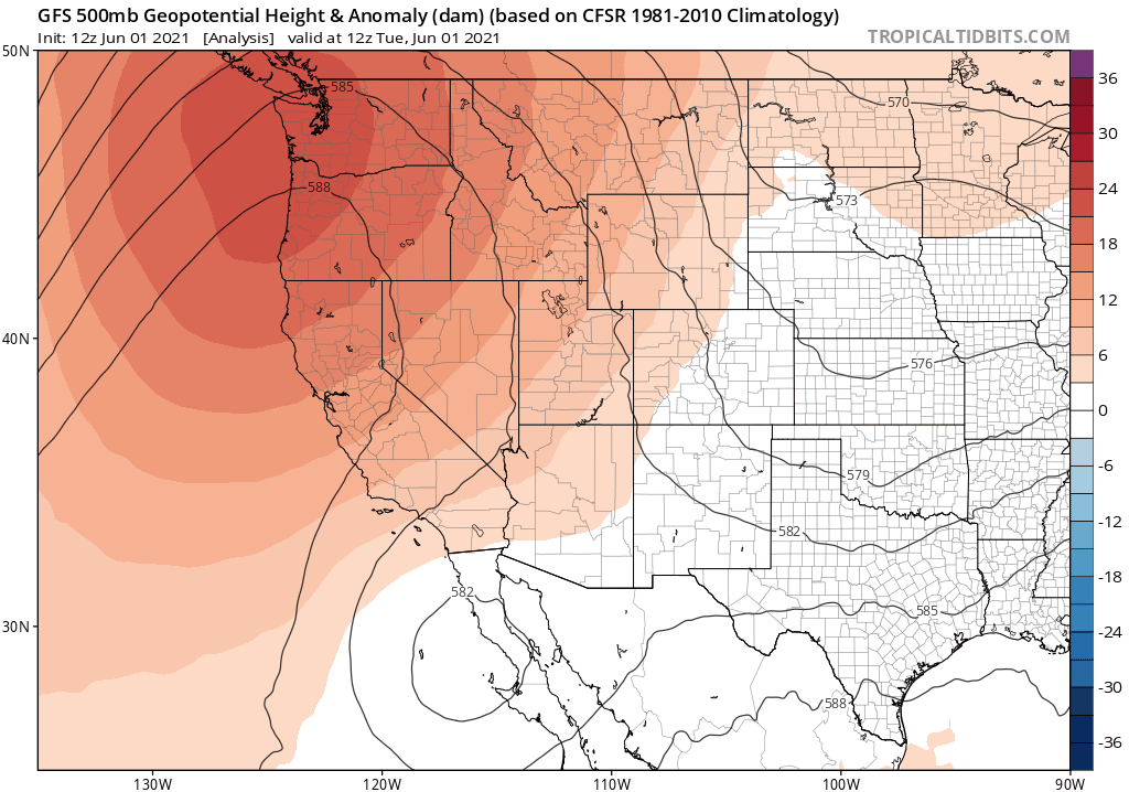
A ridge of high pressure is over us at this time. The ridge is expected to be slowly progressive and will move to our east by early Friday.
While the ridge moves thru the result will be continued warming with possible record high and low temperatures. Along with the heat, there will be some increased moisture for a chance of Thunderstorms on Wednesday and Thursday.

By Friday a cut-off low will be dropping down the California coast. Its forecasted position as of today would allow for Thunderstorms to develop again on Friday for the higher elevations above Bishop to Mammoth and up to the June Lake area.

7- 10 Day Outlook
It does appear that next week’s weather will be cooler and breezier. Check out the GFS gif below it goes out 10 days and shows a large cold low off our coast in the 7-10 day period. You can kiss the warm Summer highs goodbye if this verifies.

_______________
Air Quality and Fire Weather Watch
So far the air quality is perfect from Mammoth Lakes down to Bishop and in all the backcountry areas above us.
Most of California is clear however I can see a couple of fire starts several 100 miles to our west on the satellite view.
Currently under fire restrictions, the Town of Mammoth Lakes and the Inyo National Forest.
There are no Campfires, BBQs or Smoking allowed now out in the open. Even if you have a fire permit, it is not valid again this season.
___________________