Powder Forecast – Friday November 5th, 2021
Ted Schlaepfer CCM —- Mammoth Mountain WeatherGuy
Snowfall forecasts are valid at the Sesame snow course (Main Lodge) for the prior 24 hours as reported in the 6-7 AM morning snow report.
**Snowfall forecast confidence ranges from very low (1) to very high (5)
Sat 11/6 = 0”
Sun 11/7 = 1 – 2” (H20 = 0.10” – 0.20”) **3
Mon 11/8 = ~1” (H20 = 0.05” – 0.10”) **3
Tue 11/9 = 3 – 9” (H20 = 0.50” – 1.00”) **1
Wed 11/10 = 10 – 15” (H20 = 1.25” – 1.50”) **1
Thu 11/11 = 0”
Fri 11/12 = 0”
Sat – Mon 11/13 – 15 = 0”
November Snowfall = 0”
November Forecast = 20– 40”
Detailed 4-day Snowfall Forecast:
Sat 11/6 – Dry during the day and through the evening hours with light snowfall developing late at night. Accumulations 1– 2” by Sunday AM and ~2” up top
Sun 11/7 –Light snow showers are expected during the morning, ending midday. Accumulations ~1” by Monday AM and ~1-2” up top
Mon 11/8 – Dry during the day with increasing winds, then snowfall develop during the evening and continues overnight, may be heavy at times by early Tuesday. Accumulations 3– 9” by Tuesday AM and 6 – 12” up top
Tue 11/9 –Snow, possibly heavy, is expected during the morning into midday hours before snowfall tapers off during the afternoon and ends Tuesday evening. Accumulations 10 – 15” by Wednesday AM and 18”+ up top
Forecast Summary:
Short Term (Days 1 – 4):
The current infrared satellite image (below) shows clouds moving into NorCal associated with a weather system that will stay well north of Mammoth and mostly in the PacNW. Its main affect for Mammoth will be just some passing high clouds and slightly cooler temperatures Saturday.
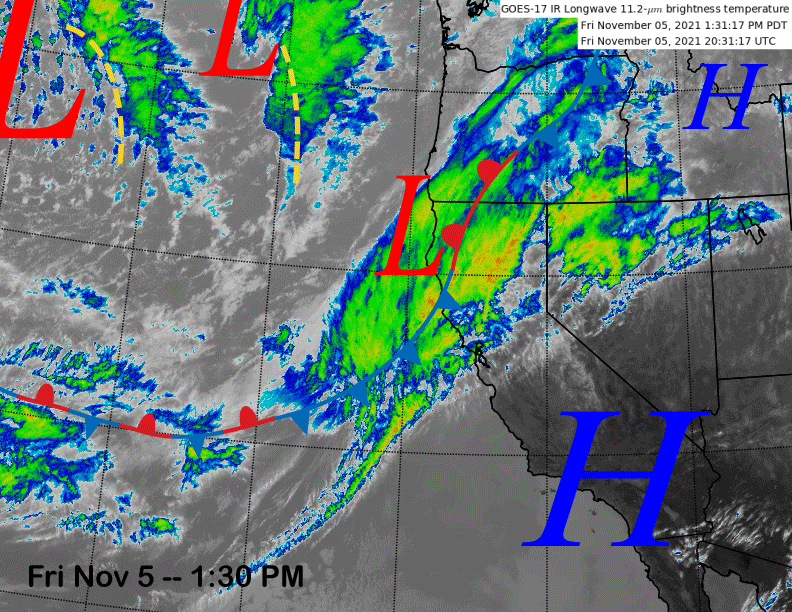
Models then move another trough of low pressure into NorCal on Sunday (image below) with the cold front expected to dissipate as it moves southward along the spine of the Sierra overnight Saturday and into Sunday midday.
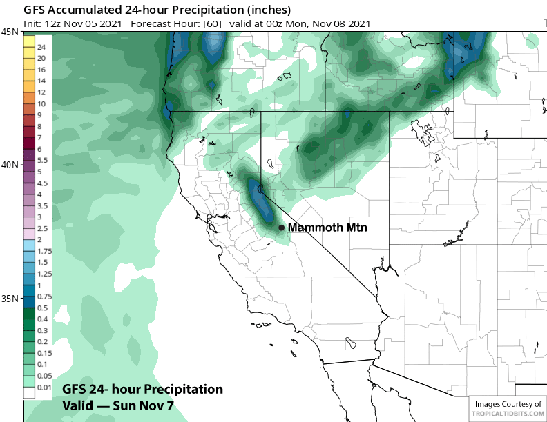
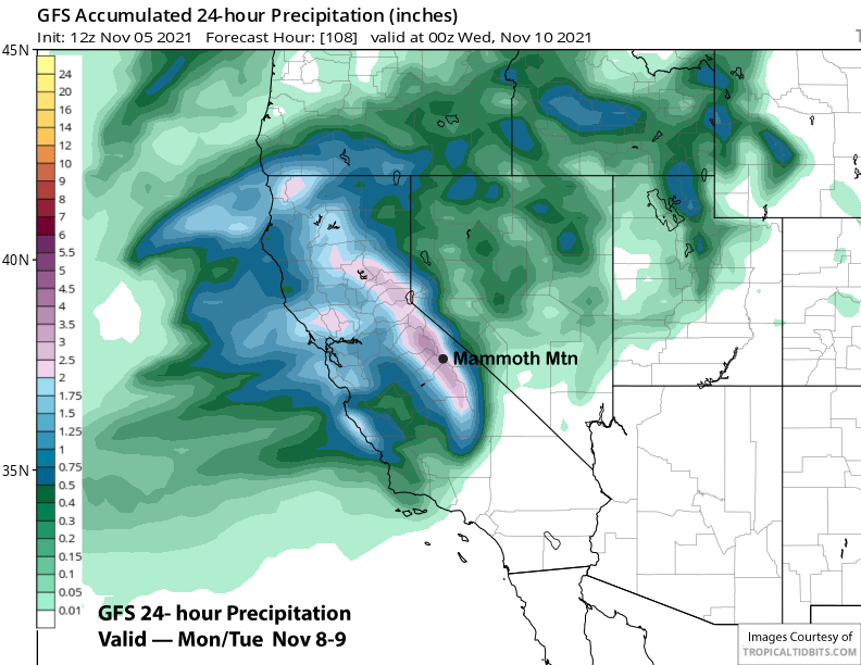
The ECM only has flurries or light snow showers with the passage of the front Sunday, but the GFS (image below) and the Canadian models both suggest there will be enough orographic lift associated with a southwest oriented jet stream to squeeze out a couple inches of snowfall.
Regardless, two other things will happen with the passage of the cold front. First, temperatures will drop to seasonably cold levels and allow for snowmaking to happen again.
Second, with cold air in place, the next upstream system that may contain an atmospheric river (AR) will NOT push snow levels up above 9000 feet and allow for evaporative cooling to keep snow levels below town elevations before the colder air with the front does the same thing.
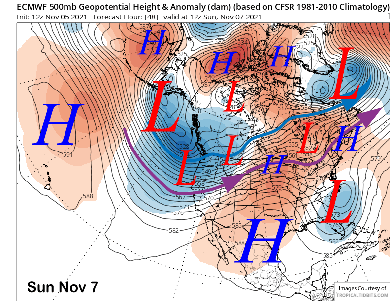
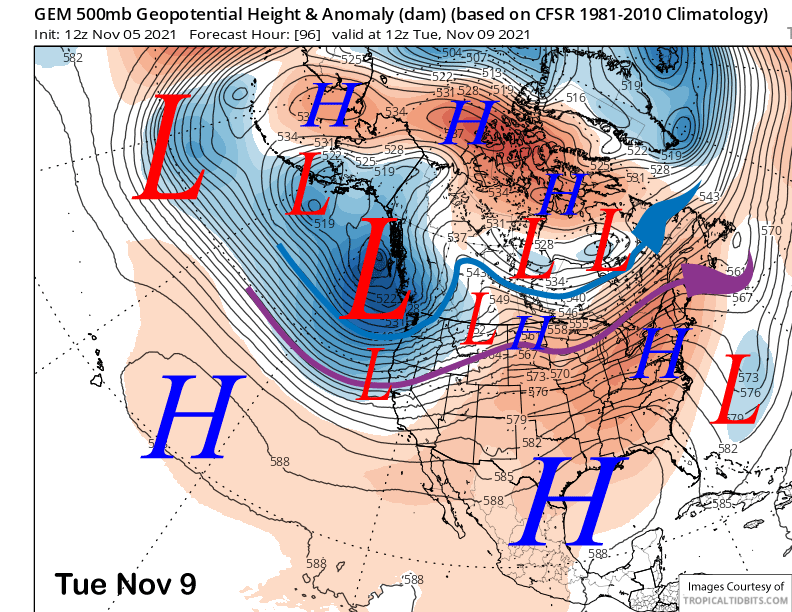
The aforementioned storm system is forecast by the models to move into CA and the Sierra Monday night and Tuesday (ECM image below).
However, there are big differences within the guidance about the strength/deepness of the upper level trough and whether a consolidated jet stream/moisture plume will move into Central CA.
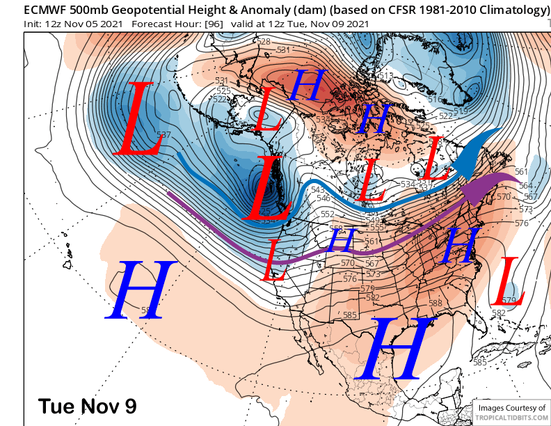
The ECM model above is the weakest and farthest north with the trough while the Canadian model is the strongest and farthest south (image below).
The GFS and GFS ensemble mean are much stronger than the ECM, but not quite as deep as the Canadian.
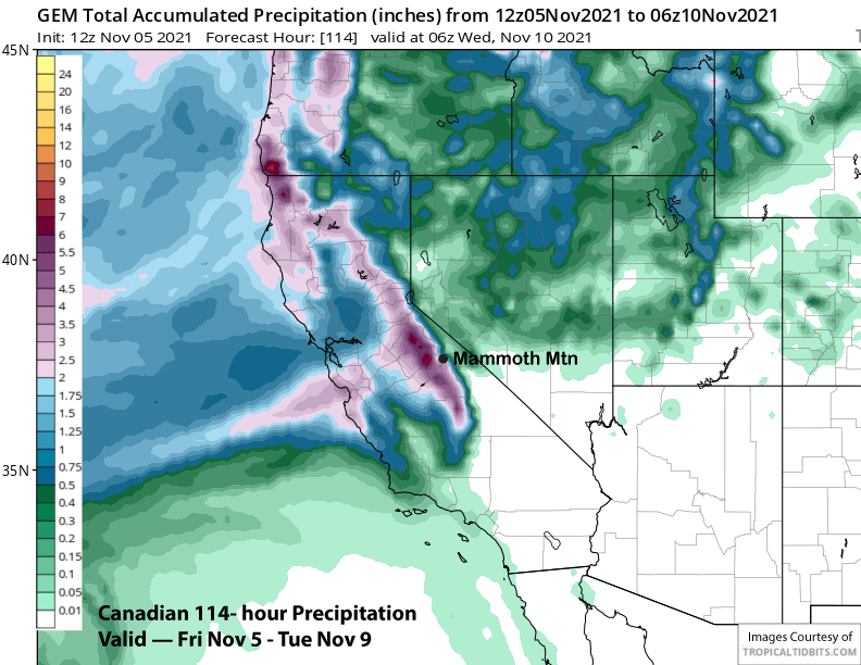
The end result is a huge variance in the predicted precipitation by these models for the storm system. The Canadian, as expected, is the wettest with about 5-6” liquid over the Sierra crest west of Mammoth (image below) while the GFS model is showing about 3-4” liquid (two images below).
The latest ECM run, however, is showing only a little bit more than a half an inch. That would equate to less than 6” snowfall by the ECM, almost 3 feet per the GFS, and around 4 feet or more per the Canadian.
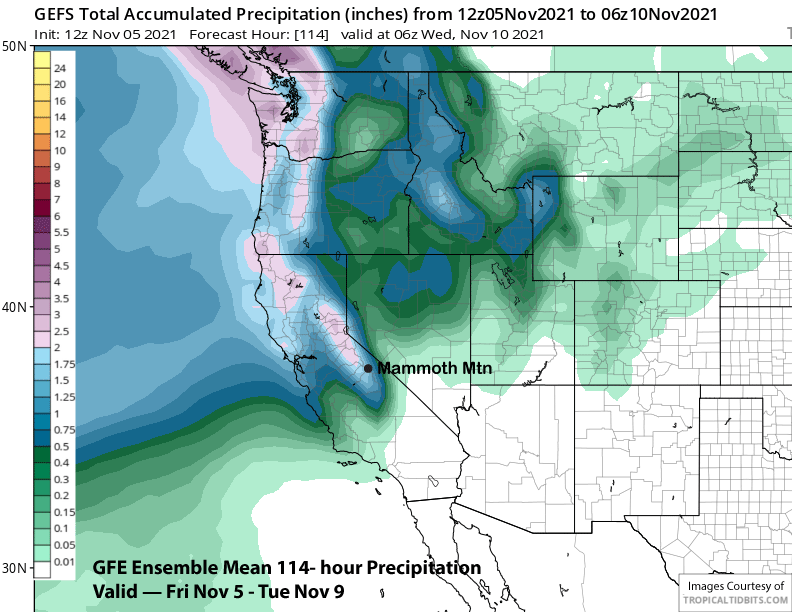
Current forecast follows the GFS ensemble mean (image below) that has just under 2” liquid and not the ECM mean that has less than an inch.
The ECM model totally undershot the precipitation with the last event and I am not convinced that it is the best model anymore. Recent upgrades seemed to have worsened its performance versus previous versions.
Hopefully the wetter solutions will verify and overall, this is a low confidence forecast due to huge model differences. But there is a good shot for a storm riding day Tuesday followed by a powder day Wednesday when dry weather returns.
Long Range (Days 5+):
The longer-range guidance is looking fairly dismal after the potential storm for next week. Dry weather will return Tuesday night and there are no clear signs of anymore impending storms in the foreseeable future with a decent chance that the rest of November may remain dry.
Model guidance is in good agreement that a strong high-pressure ridge (image below) will build into Mammoth and the state by the end of next week. That will result in fair and seasonably warm weather and poor snowmaking conditions.
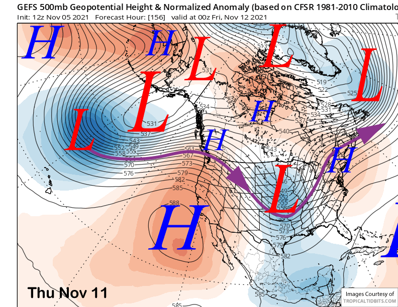
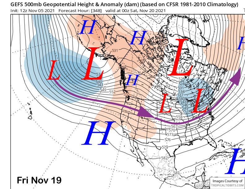
While the ridge is forecast to weaken over the following week, it is forecast by the ensembles to mostly remain in place through the 3rd week of the month (image below) or longer. The guidance is suggesting a chance for inside slider type systems over the last week of the month, but those systems don’t produce much/if any snowfall and usually just means colder temps.
Super long range climate model forecast from the ECM and CFS both keep the dry weather in place until possibly the very end of the month, and more likely into early December. This is nothing unusual, in 2004, October had big snowfall, but November was mostly dry. It is still early in the season and seasonal precipitation typically doesn’t kick into gear until December. WG


