
Recreational Weather Forecast for Mammoth Mountain & the Eastern Sierra
Sunday, December 5th, 2021 @ 3:57 PM – Big Changes are on the way in the weather for Mammoth Mountain, Mammoth Lakes, the entire Eastern Sierra.
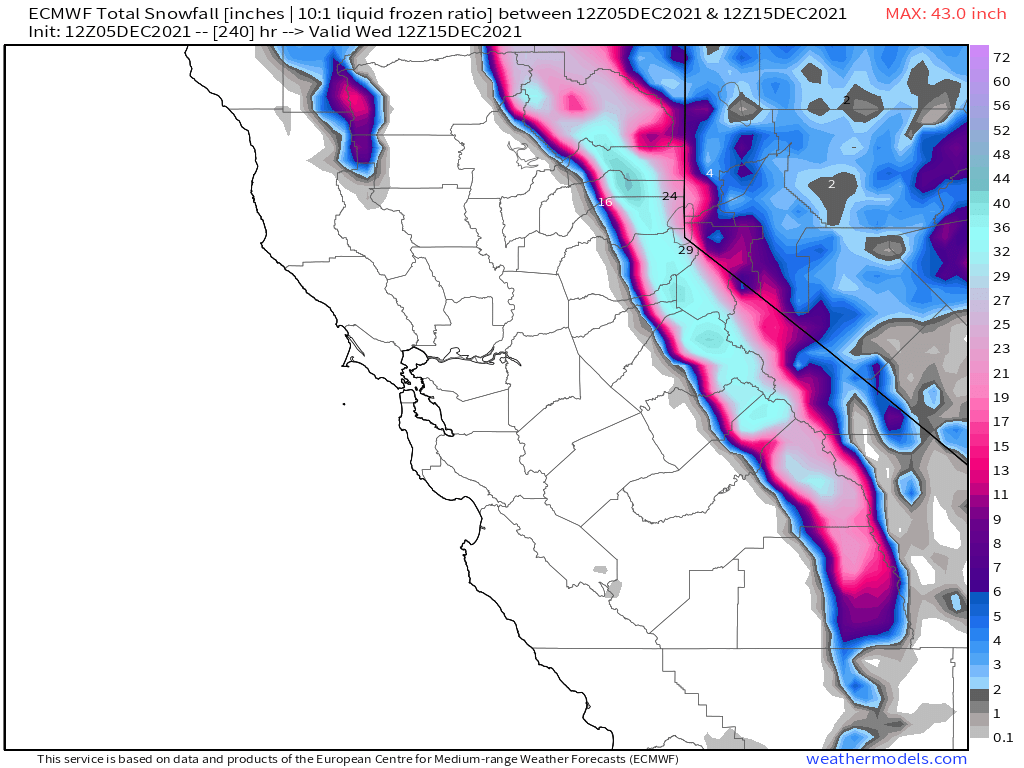
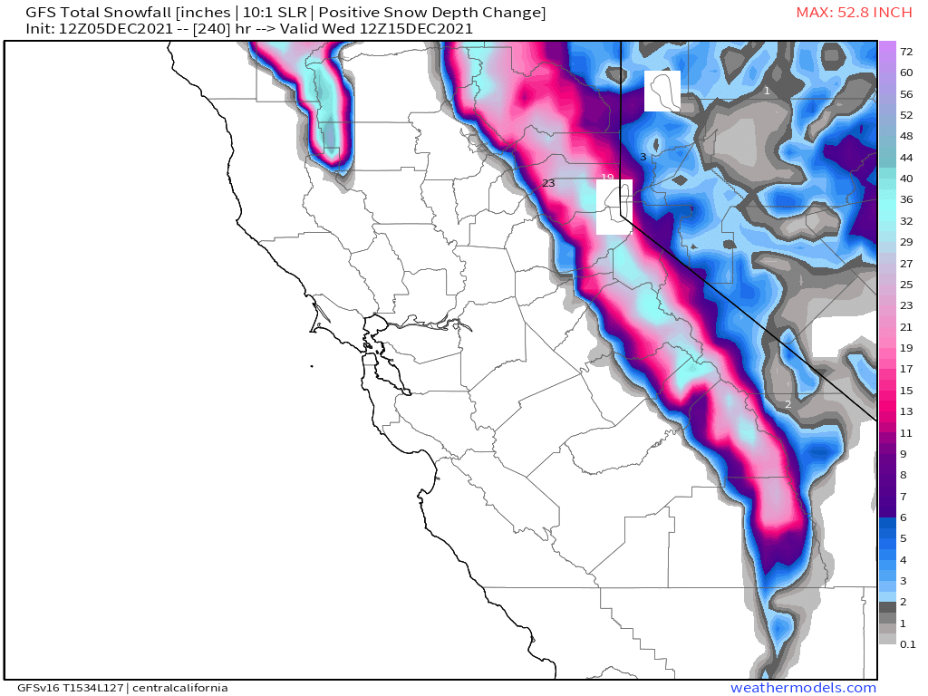
A series of storms looks to move through the area over the next 2-3 weeks. How much snow we get is still uncertain but at this point, the ski area could pick up several feet of snow over that time frame.
If you’re going to be out on the hill on Monday expect clear skies with increasing clouds during the day. Lower mountain winds 15-20 MPH at times, mid Mountain winds will be gusting 35-45 with gusts to 55+ over the top. Highs will be in the upper 40s too low 50s with a morning low around 32. Monday night snow is in the forecast with 1-2 inches possible from Main Lodge up.
For Tuesday & Wednesday expect clear skies with light winds and highs in the mid to upper 40s. Nighttime lows will be in the upper 20s.
Wednesday night into Thursday snowfall is likely with highs in the upper 20s along with gusty winds. As of now, snowfall amounts look to be in the 6-12 inches range from Canyon to Main Lodge.
Next weekend looks clear on Saturday and Sunday, but with winds picking up again on Sunday ahead of the next possible potent storm system.
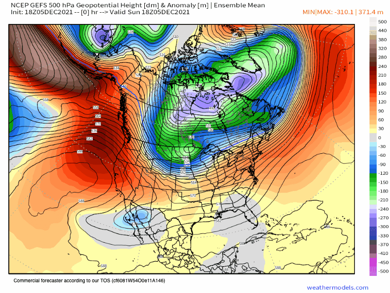
As of today, charts are showing that for week 2 the next trough sets up off the west coast, which should open the door to some more productive snowfall for Mammoth Mountain and the entire Sierra Range.
The GFS model keeps wanting to bring in a strong AR event while the other models aren’t seeing that yet.
Locals, over the next few days I would get out for a hike or bike ride before there is snow on the ground and it’s cold in the High Country for an extended period.
Ski Ya Later Snowman
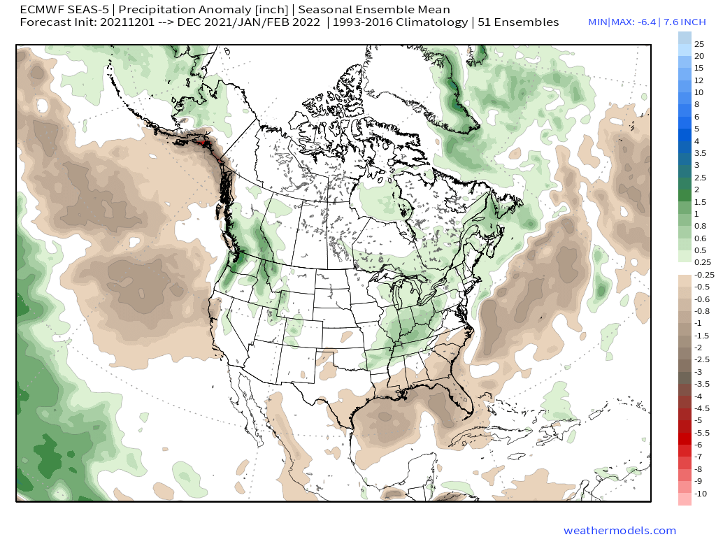
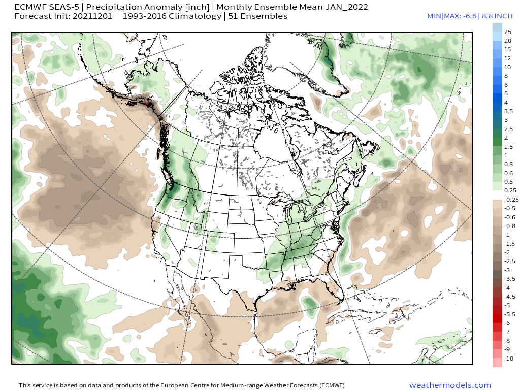
Image Below: ECMWF Seasonal Update just came out for the next 90 days. I like it when it’s green over Mammoth and you should to.


The good news today is after weeks of warm and dry weather there is a pattern change in store for Mammoth Mountain and the Eastern Sierra.
As of now, confidence is medium that the Eastern Sierra will transition to a colder and wetter pattern over the next several days. The change, if it actually takes place, would turn the region into a Winter Wonderland just in time for the Holidays.
While we do not expect major amounts of snow, the ski area looks to possibly receive several feet of snow along with cold air for snowmaking to resume. Lower elevations could receive multiple inches of snow that could add up to a foot or more.
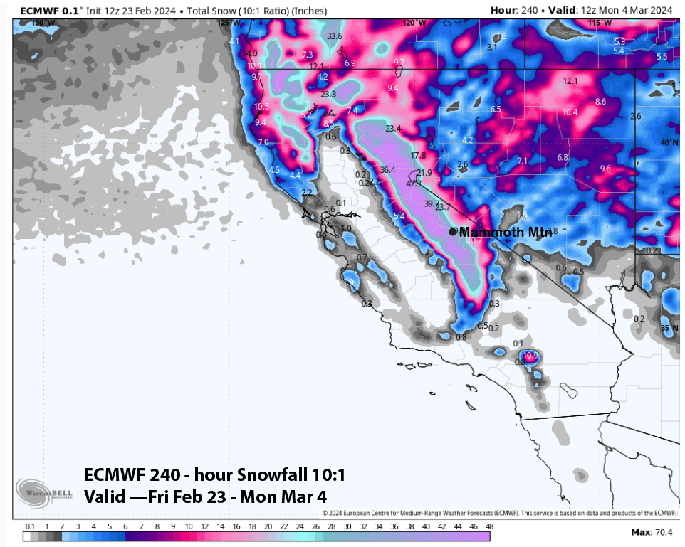
As of Sunday night looking at QPF totals over the next 10 days, the GEFS is at 10 days 2 1/2 inches of water or 20-30 inches of snow.
The GFS has 3.23 inches of water with 3 feet of new snow. The EU model 3.45 with most of that from the Monday / Tuesday system at day 9 and 10.
 Here is the next 16 days on the GEFS, nothing major but it does show some decent snowfall in the forecast.
 Below you will find the brand new updated ECMWF Seasonal Outlooks
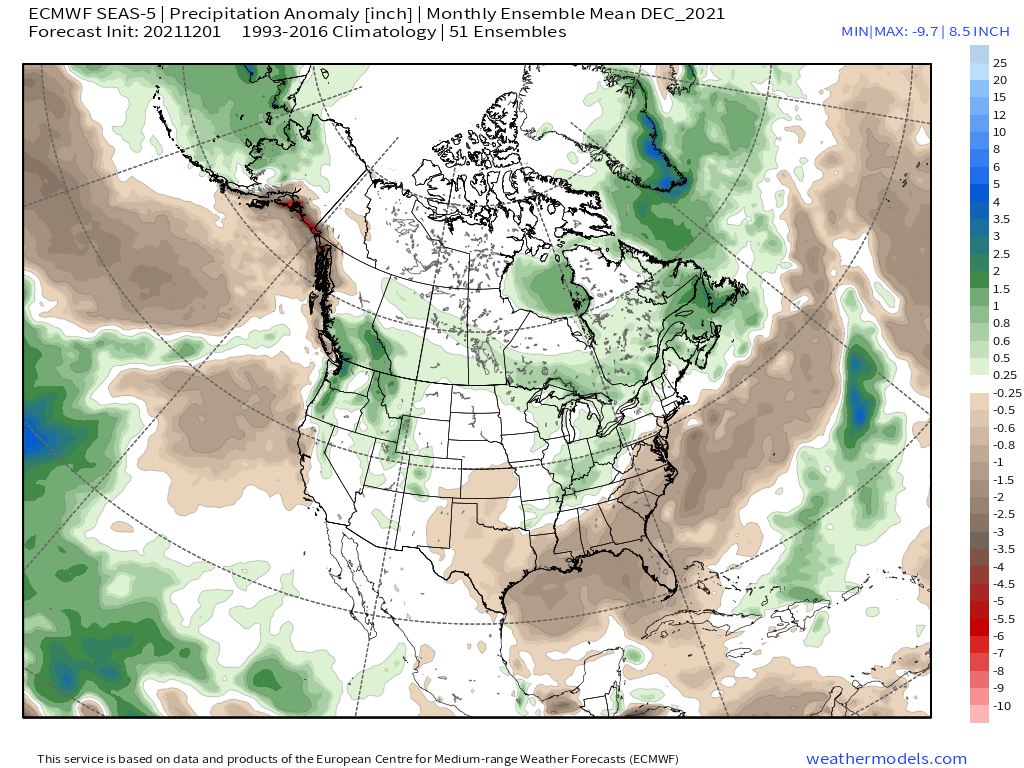 …
…


")

")
")
")
")


Who Are We?
 Steve Taylor – Mammoth Snowman – Over the last 30+ years, Snowman has spent countless hours studying and learning about Mammoth Mountain Weather and Snow Conditions first hand. He has been skiing around the hill with marked ski poles since March of 1991 so he can measure the fresh snowfall amounts out on the hill.
Snowman started blogging this information back in 1990 on the old Mammoth BBS system, then the RSN Forums and then on to MammothSnowman.com in 2004 with Video & Photo Blog report. (No YouTube back then). Facebook got added to the fold back in 2008 and then the Facebook Group in 2016.
Reports, videos, and photos from the website have been featured on both local TV Stations here in Mammoth, along with AP, Fox, ABC, CBS, and NBC News.
 Ted Schlaepfer – Mammoth WeatherGuy – The Powder Forecast – Posted Tuesday and Fridays at 5 PM November into Mid May. These forecasts are now responsible for many people getting multiple powder days on Mammoth Mountain over the years.
Ted’s Bio: Ted has been a full-time Meteorologist (CCM) for the past 25+ years. He has always been fascinated with the weather,” skiing was just a natural extension of my love for snow and rain. I started skiing at age 5, first discovered Mammoth in 1979 as a youth, and have been a regular visitor since the late ’80s.”.
Here is the link to The WeatherGuys Powder Forecast Page.
Click Here to Learn More About the People Who Make MammothSnowman.com a Reality


