
Recreational Weather Forecast for Mammoth Mountain & the Eastern Sierra
Monday, December 7th, 2021 @ Noon – Hello and good afternoon, the change in the weather has begun with a dusting of snow over Mammoth Mountain and all the peaks in the Eastern Sierra.
This was the 1st in a series of storms that looks to affect Mammoth Mountain and the Eastern Sierra over the next several weeks. The second system will move in Wednesday night into Thursday with system 3 scheduled for late on Sunday.
If you’re going to be out on the hill on Windy Wednesday you can expect clear skies with a southwest wind @ 15 to 20 mph increasing to 25 to 30 mph in the afternoon with gusts to 50+ MPH mid-mountain.
Highs will be the mid-30s with mornings lows in the mid-20s. Layer up it’s going to feel cold after weeks of warm days out on the hill.
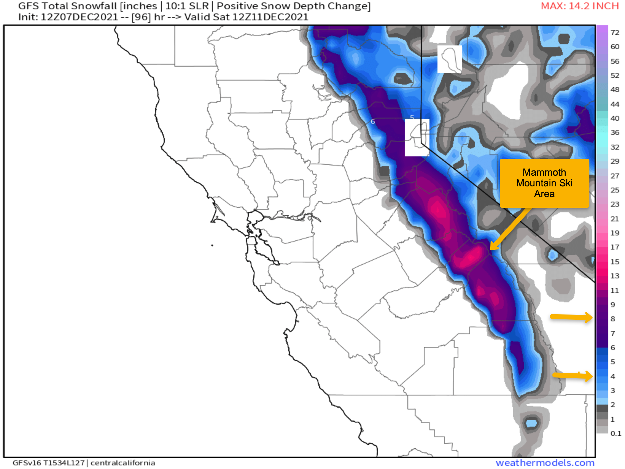
The second weather system in this series comes on Wednesday evening and while it’s looking on the weak side there could still be 4-8 inches of fresh snow.
Snow rations look to be in the 12 – 1 range with snow possibly mid-way down the Sherwin grade on Thursday.
This system is a cold hybrid inside slider so the snow that falls will be soft and light making for some great packed powder on the open groomers.
It will not be time to search powder out yet with a 1-2 foot base on the hill, so beware, save it for later.
 Friday – Sunday This will be the calm before a long snow cycle.
Friday and Saturday will be clear and cold with highs in the mid-20s Friday and upper 20s on Saturday with light winds. Lows will be in the teens for a cold start to the day.
On Sunday expect winds to be increasing in the morning with a chance of snow before nightfall now. If what we are looking at now comes to pass Sunday could be a blowout with lift closures.
Snowmaking: Good Snowmaking conditions look to be back Tuesday night and Wednesday.
Beyond that, the coldest air mass of the season will be coming in with some really great snowmaking conditions for the crews to lay some base down.
All the guns are set up at Canyon and around the heavy traffic areas that need the snowmaking base. I would expect a massive effort from snowmaking crews coming up.
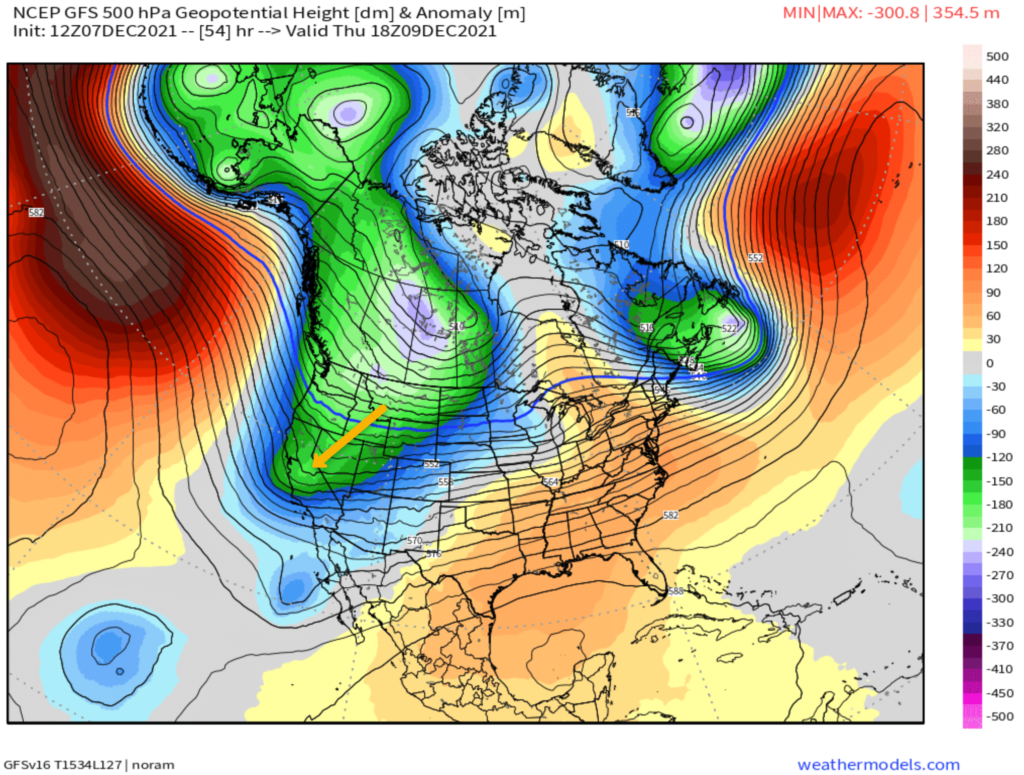
Next Week Storm System 3 & 4 – The first system will come from a long wave trough that is off the west coast, not an inside slider. It’s looking more and more likely that this low will be very deep and will have a subtropical tap.
Add in this is about the best time of year for a storm like this to be extremely productive. If this system comes in as it looks today it will be the event that will be saving your ski and snowboard season.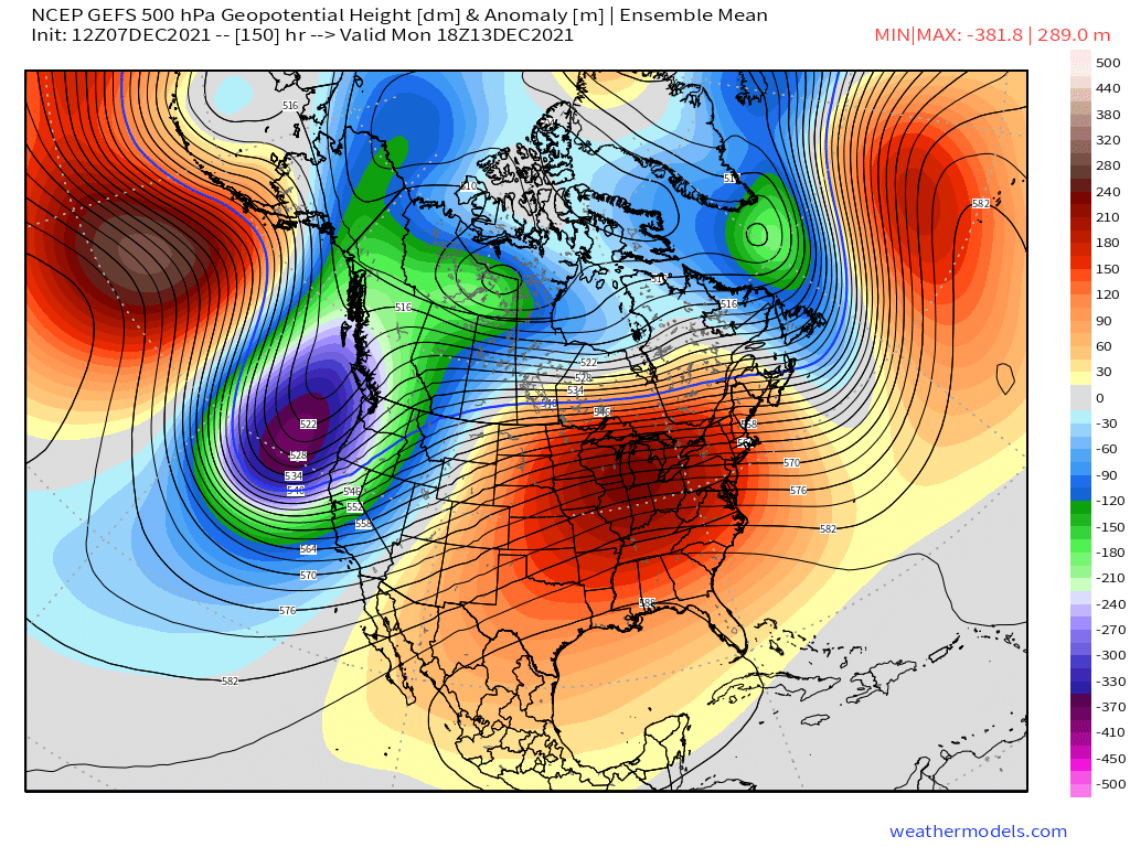
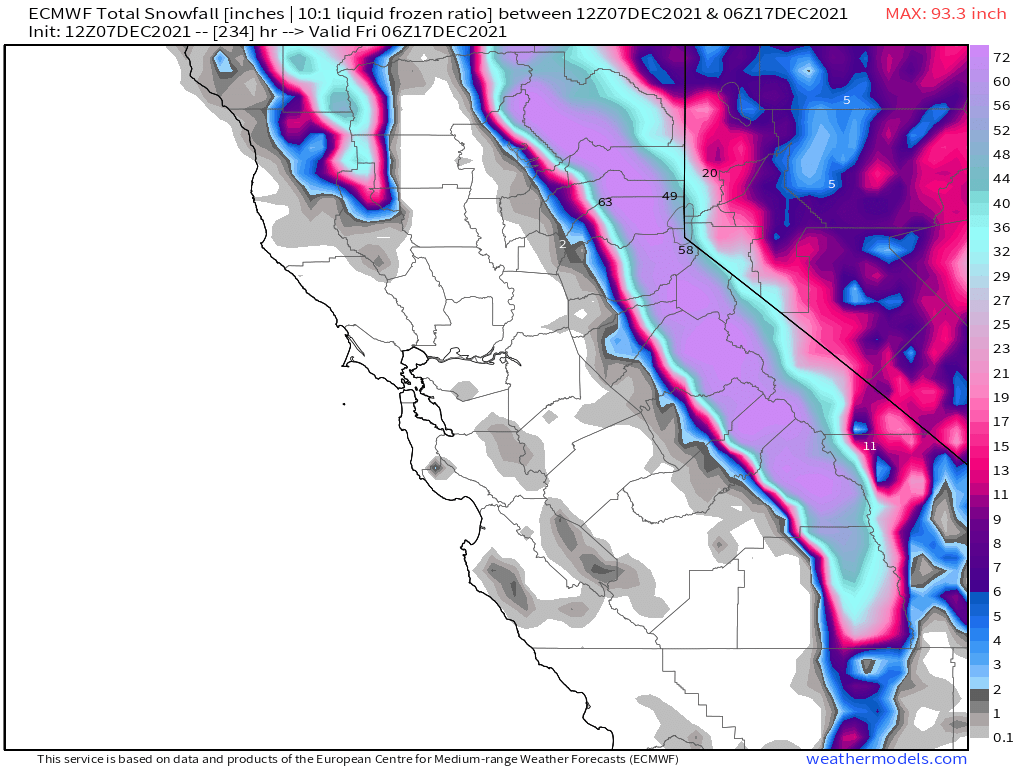
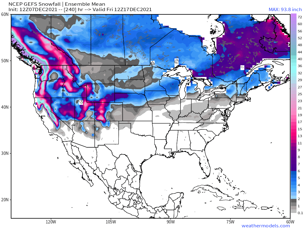
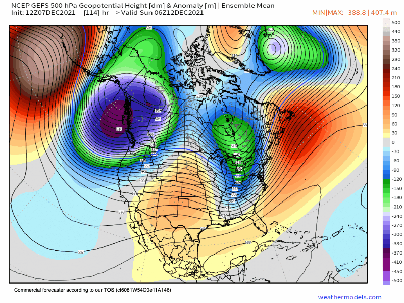 Snowfall amounts this far out are a bit suspect and of low confidence. However, when you start to see the operational and the ensembles all showing several feet of snow it’s time to really start paying attention.
The GFS nailed the October AR event when Mammoth got 7 inches of rain and then it snowed 2 feet.
It’s been showing more often than not some big QPF numbers for next week. Just like it did 6 weeks ago. The big difference is the time of year now, so this will be snow, not rain.
This morning the GFS has 8-10 inches of water coming in over the next 10 days. That amount of QPF of course would add up to excessive amounts of snowfall.
Snow levels on the GFS start as all snow on Mammoth Mountain and come down to Bishop by next Tuesday night.
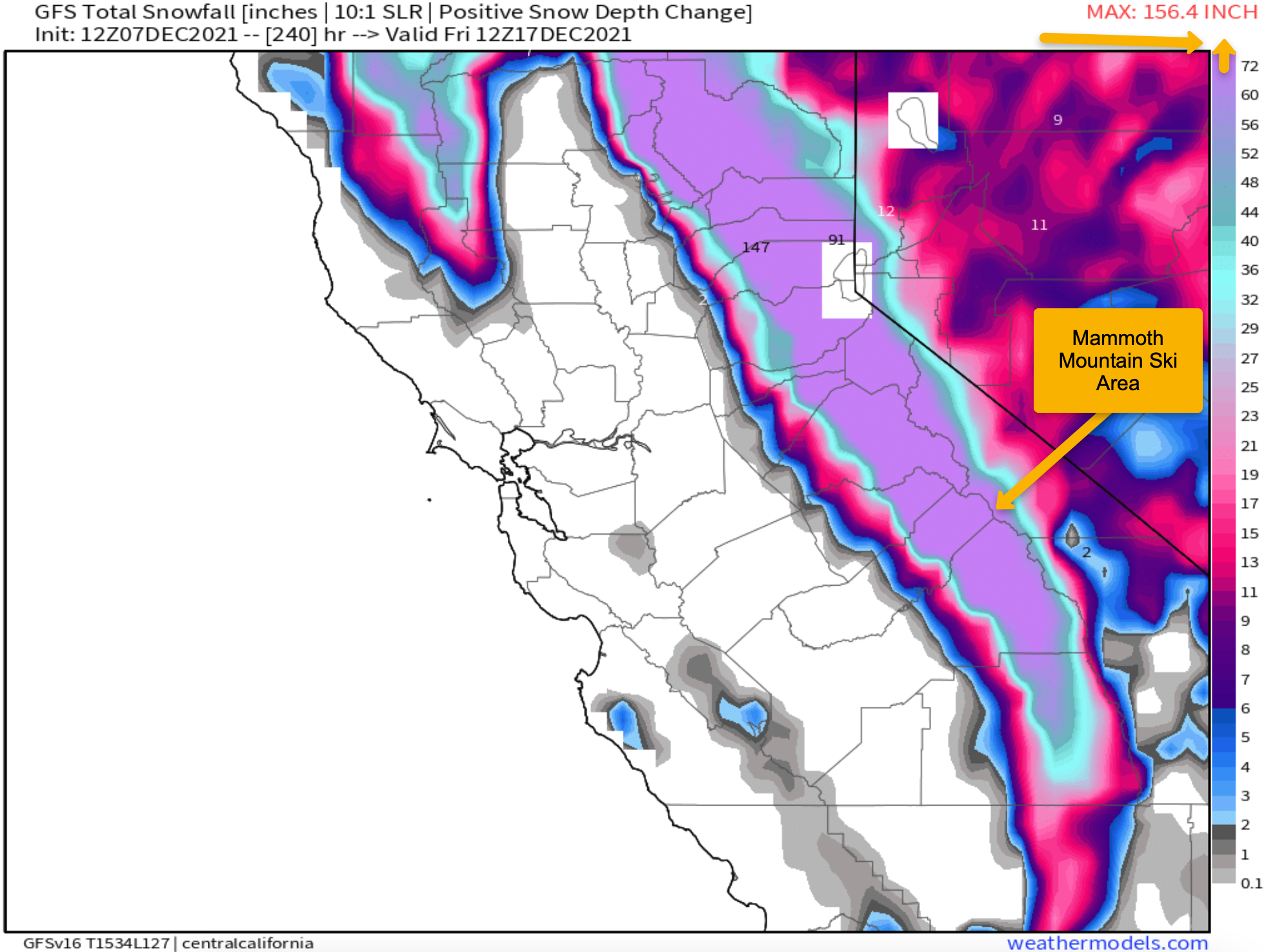
Looking at the GEFS ensemble it has 4-5.5 inches of water, with the EU at 7-8 inches. The EU has always been our preferred weather model of choice but has had some issues recently.
This type of weather event if it comes to pass would turn the area into a Winter Wonderland and offer up some of the best skiing and boarding we have had in over 2 years.
The good news for everyone is that snow is coming to all of the Western Ski Resorts, so it could be a very Merry White Ski and Snowboard Holiday for all.
Beyond day 10 the ensembles show continued snowfall out to day 16 and beyond. While I don’t see anything major there could be some almost daily refreshing snow falling. Going to be a bit shocking after all the dryness the last few years.
Ski Ya Later Snowman


")

")
")
")
")


Who Are We?
 Steve Taylor – Mammoth Snowman – Over the last 30+ years, Snowman has spent countless hours studying and learning about Mammoth Mountain Weather and Snow Conditions first hand. He has been skiing around the hill with marked ski poles since March of 1991 so he can measure the fresh snowfall amounts out on the hill.
Snowman started blogging this information back in 1990 on the old Mammoth BBS system, then the RSN Forums and then on to MammothSnowman.com in 2004 with Video & Photo Blog report. (No YouTube back then). Facebook got added to the fold back in 2008 and then the Facebook Group in 2016.
Reports, videos, and photos from the website have been featured on both local TV Stations here in Mammoth, along with AP, Fox, ABC, CBS, and NBC News.
 Ted Schlaepfer – Mammoth WeatherGuy – The Powder Forecast – Posted Tuesday and Fridays at 5 PM November into Mid May. These forecasts are now responsible for many people getting multiple powder days on Mammoth Mountain over the years.
Ted’s Bio: Ted has been a full-time Meteorologist (CCM) for the past 25+ years. He has always been fascinated with the weather,” skiing was just a natural extension of my love for snow and rain. I started skiing at age 5, first discovered Mammoth in 1979 as a youth, and have been a regular visitor since the late ’80s.”.
Here is the link to The WeatherGuys Powder Forecast Page.
Click Here to Learn More About the People Who Make MammothSnowman.com a Reality


