Powder Forecast –Friday December 10th, 2021
Ted Schlaepfer CCM —- Mammoth Mountain WeatherGuy
Snowfall forecasts are valid at the Sesame snow course (Main Lodge) for the prior 24 hours as reported in the 6-7 AM morning snow report.
**Snowfall forecast confidence ranges from very low (1) to very high (5)
Sat 12/11 = 0”
Sun 12/12 = 0”
Mon 12/13 = 5 –6” (H20 = 0.50” – 0.60”)**3
Tue 12/14 = 44 –49” (H20 = 4.50” – 5.00”)**4
Wed 12/15 = 20 – 25” (H20 = 2.00” – 2.50”)**4
Storm total = 69 – 80” (H20 = 7.00” – 8.10”)**4
Thu 12/16 = 2 –3”
Fri 12/17 = 2 –4”
Sat – Mon 12/18 – 20 = 0”
December Snowfall = 11”
December Forecast = 100 – 120 ”
Detailed 4-day Snowfall Forecast:
Sat 12/11 – No snowfall expected.
Sun 12/12 – Dry during the morning, then light snowfall starts during the afternoon and increases overnight and into Sunday. Winds increase toward dawn as well. Accumulation 5 –6” Main and up to 6” up top
Mon 12/13 – Snow and wind increase during the morning hours, becoming heavy by the afternoon and evening. Blizzard conditions expected overnight Monday with very heavy snowfall, 3-4” inch per hour rates. Accumulation 43 –49” Main and 60”+ up top
Tue 12/14 –Blizzard conditions during the morning and likely whiteout conditions. Heavy snow continues into the afternoon before tapering off during the evening and ending overnight. Accumulation 20 –25” Main and up to 30” up top
Forecast Summary:
Short Term (Days 1 – 4):
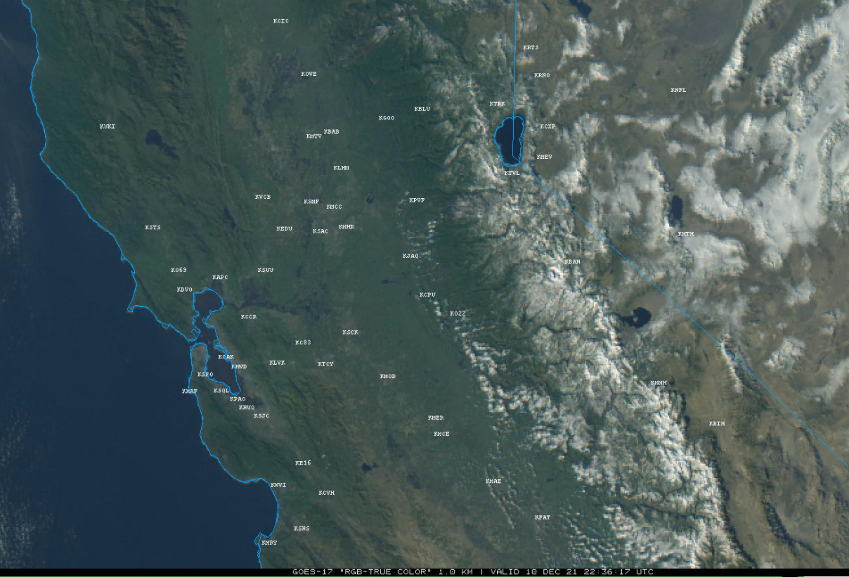
The current visible satellite image (below) shows mostly clear skies over the state and a fresh layer of snow over the Sierra from the storm yesterday that dropped almost a foot of snow. Dry weather will continue tomorrow and likely into Sunday morning.
The numerical guidance is still in alignment and confidence is now very high that a major snow storm will impact the Mammoth Lakes region starting Sunday afternoon and continuing through most of Tuesday.
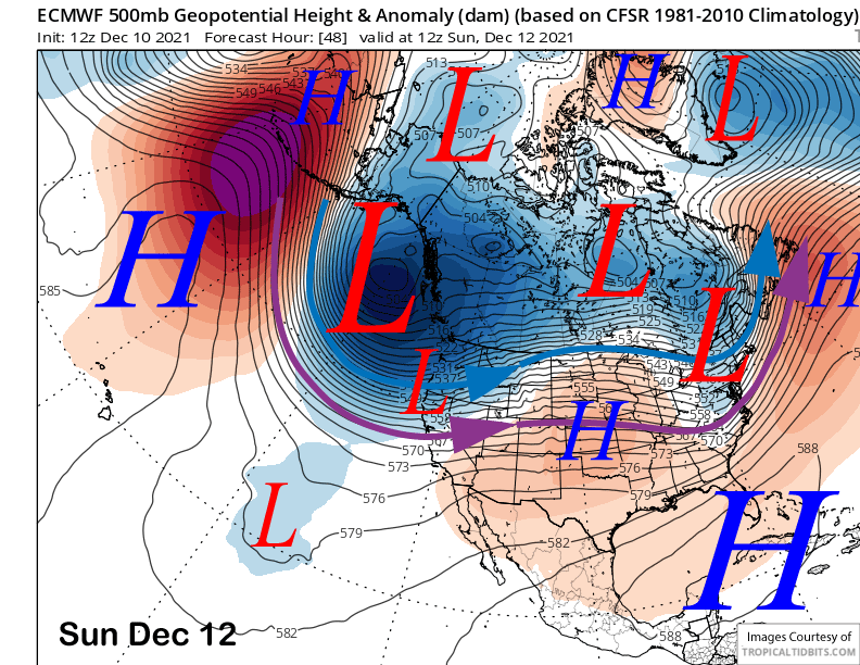
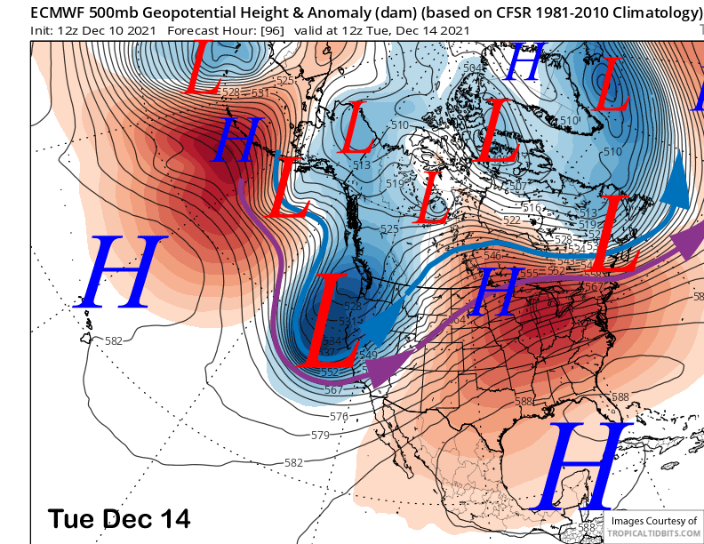
The latest ECM model moves a very deep upper level trough southward along the West Coast Sunday (image below) in response to building high pressure over the Aleutians associated with a MJO event that has now moved into phase 7 and about on time per the ECM forecast from a few weeks ago (see Nov 19th post) when I stated “That said, this will be a good case to watch as the MJO generally is not well predicted beyond a week or two. Can the ECM model predict the position and relative strength of the MJO 3-4 weeks out? Let’s hope so cause that would mean lots of snowfall for the Sierra and Mammoth”.
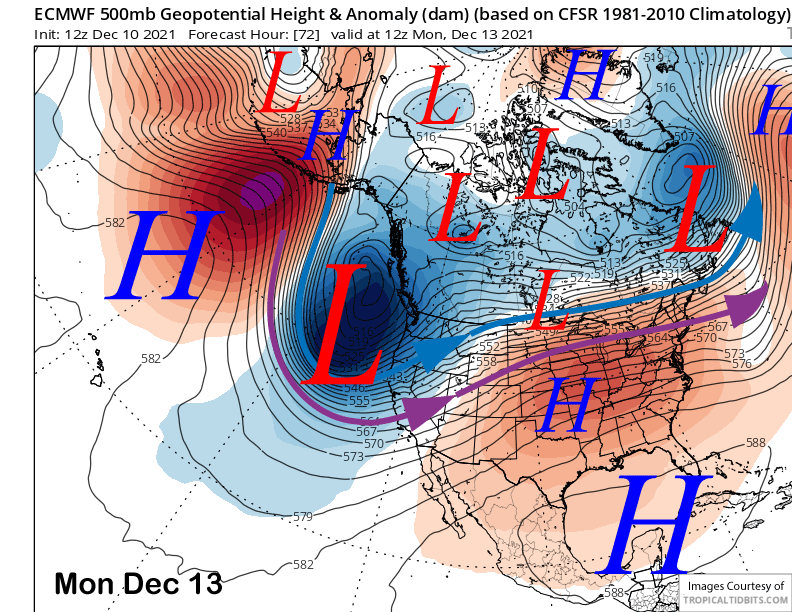
The upper-level trough is expected to continue to deepen and move southward into CA on Monday (image below) and then through the Sierra on Tuesday (two images below). As it does so, a very strong and cold polar jet stream (blue arrow) will move into the Sierra by Monday and southward through the range by early Wednesday.
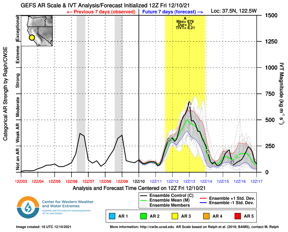
The storm will also be associated with a weak to moderate Atmospheric River (image below) that will progress southward along the coast Monday and Monday night. The strength of ARs are determined by measuring the Integrated Water Vapor Transport, and that term contains two parts. A moisture plume or the Integrated Water Vapor, and the Transport, which is the low and mid-level jet stream. In this case, the moisture plume is not that impressive and only about an inch of water vapor, but the other term, the Transport, is very strong and will phase perfectly with the plume and vertical velocity field.
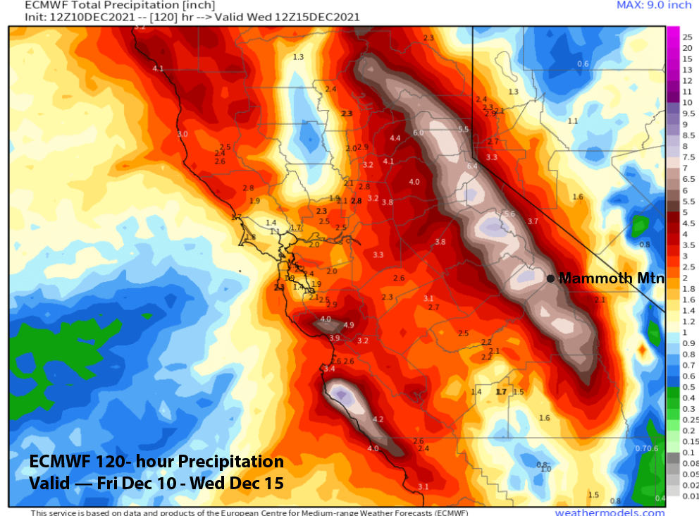
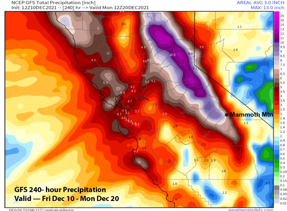
The end result will be a major Sierra snow storm including very good spill-over into the east side basins and valleys, including Bishop, where a couple inches of rain could fall. For Mammoth, the ECM model (image below) is projecting about 7” liquid for Main while the GFS has a bit more (two images below) and more west of the Sierra crest where it is forecasting close to 9” liquid. The GFS has a bit more because it moves the storm through the Sierra a bit slower than the ECM and Canadian models.

It looks like snow will start Sunday afternoon and then increase overnight into Monday. Snow intensity should increase Monday during the day followed by blizzard conditions overnight Monday and Tuesday morning. Heavy snow should continue Tuesday before tapering off Tuesday evening and ending overnight.
Winds will also increase Sunday and into Monday and become very strong Monday afternoon and night with continued strong winds through Tuesday morning. Gusts over 100 mph are likely up top and maybe even top of Chair 1. Winds should decrease by Tuesday afternoon. The other issue with the strong winds is it could lead to snow dendrite fracturing and lower liquid to snow ratios.
Overall, it looks like about 6 feet or so should fall at Main, over 7 feet up top, about 5 feet at Canyon, and 4-5 feet in town. Looks like the airport will get 3-4 feet. Snow levels will start out around 7000 feet before falling to near 5500 feet Monday morning. They may rise briefly back to 6500 feet Monday afternoon with the snow levels during the blizzard conditions between 5500-6000 feet. Snow levels will fall to near 3000 feet as the snowfall is tapering off Tuesday overnight.
My guess is that the mountain might not open on Tuesday due to the combination of the large volume of new snow and gusty winds. Riders of the storm should plan on Monday. And if you are not in Mammoth by sundown on Monday, don’t even try to get here until later Tuesday or Wednesday. Travel will be very dangerous in the Sierra Monday night and I suspect the highways may be closed anyway.
Long Range (Days 5+):
The longer-range guidance is still showing a continued favorable pattern for the next couple of weeks or longer.
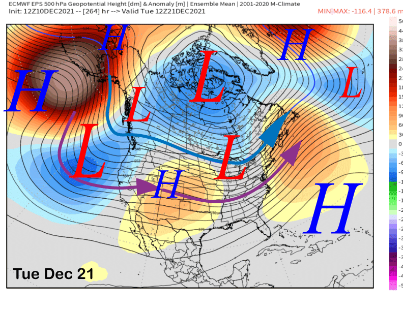
The models (ECM below) move a trailing upper-level low into CA on Wednesday and into Thursday for additional precipitation for central and northern CA. It will be much weaker than the previous storm with most of the rain/snow staying north of Mammoth. But another 4-7” of snow is possible Wednesday night and Thursday.

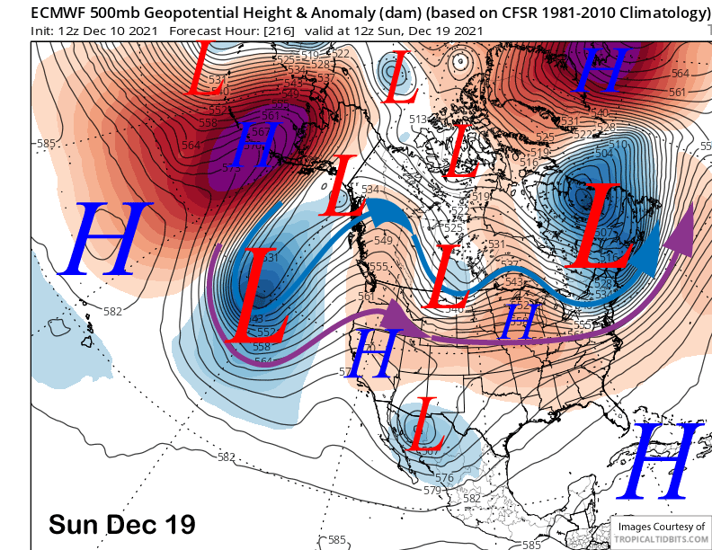
Dry weather is then forecast to return over the weekend with the ECM (image below) developing a weak ridge of high pressure over the state. That model then moves another deep upper-level low toward the CA coast early over the following week (two images below).
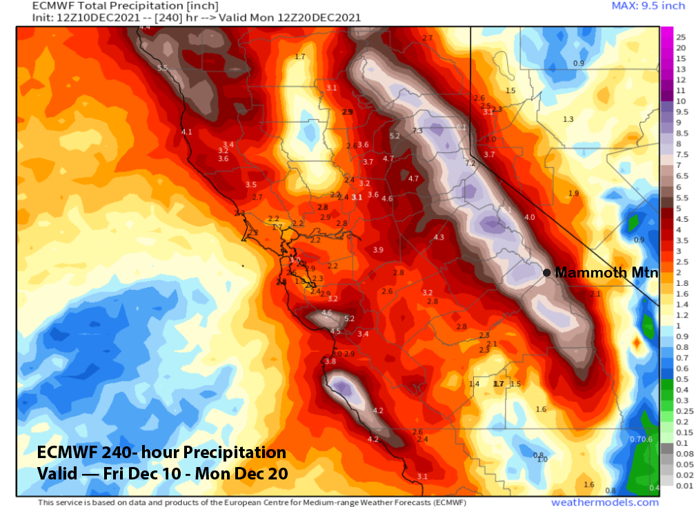
Overall, the ECM and GFS models are showing large liquid precipitation amounts in the 10-day periods (images below). Conditions over the following weekend should be splendid with the new snow, newly opened terrain, and seasonably cold temperatures.
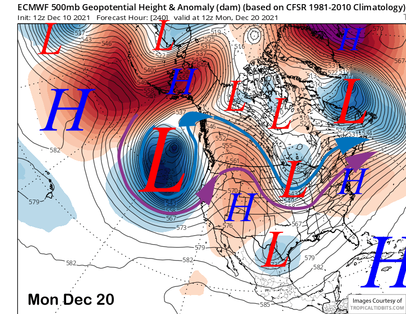
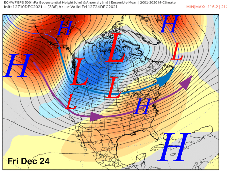
The fantasy range guidance is favoring the return of storminess during the Christmas week. Both the ECM (image below) and the GFS (two images below) are remarkably similar with the upper level pattern showing a trough along the West Coast.
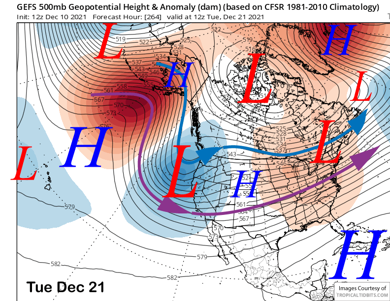
That pattern favors colder type storm systems to move into the state and could result in the colder, drier, type of snowfall. The ECM keeps this pattern going almost into Christmas (image below). So get that shopping done now and out of the way, there could be some really good powder days just before Christmas.
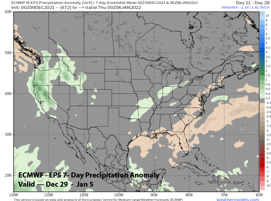
ECM climate model is suggesting a brief break from storminess just after Christmas before the pattern may reset toward the end of the year and early January. That model is showing above normal precipitation (image below) during that 7 day period. Looks like good times ahead. WG