Powder Forecast –Tuesday May 3rd, 2022
Ted Schlaepfer CCM —- Mammoth Mountain WeatherGuy
Snowfall forecasts are valid at the Sesame snow course (Main Lodge) for the prior 24 hours as reported in the 6-7 AM morning snow report.
**Snowfall forecast confidence ranges from very low (1) to very high (5)
Wed 5/4 = 0”
Thu 5/5 = 0”
Fri 5/6 = 0”
Sat 5/7 = 0”
Sun 5/8 = 0”
Mon 5/9 = 2 – 4”
Tue 5/10 = 1 – 2”
Wed – Fri 5/11 – 5/13 = 1 – 3”
May Snowfall = 0”
May Forecast = 10 – 20”
Detailed 4-day Snowfall Forecast:
Wed 5/4 through Sat 5/7 – No snowfall expected all days.
Forecast Summary:
Short Term (Days 1 – 4):
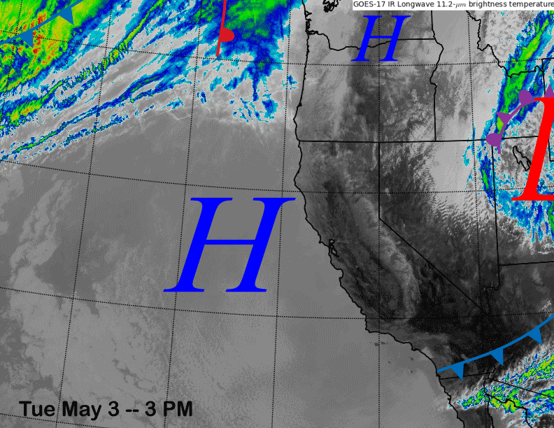
The infrared satellite image (below) this afternoon high pressure has built into the state with the weather system that moved through yesterday with the colder temps and gusty winds now positioned in Utah. High pressure will hold through Thursday and temperatures will warm up tomorrow and cool only slightly Thursday for spring conditions on all parts of the mountain.
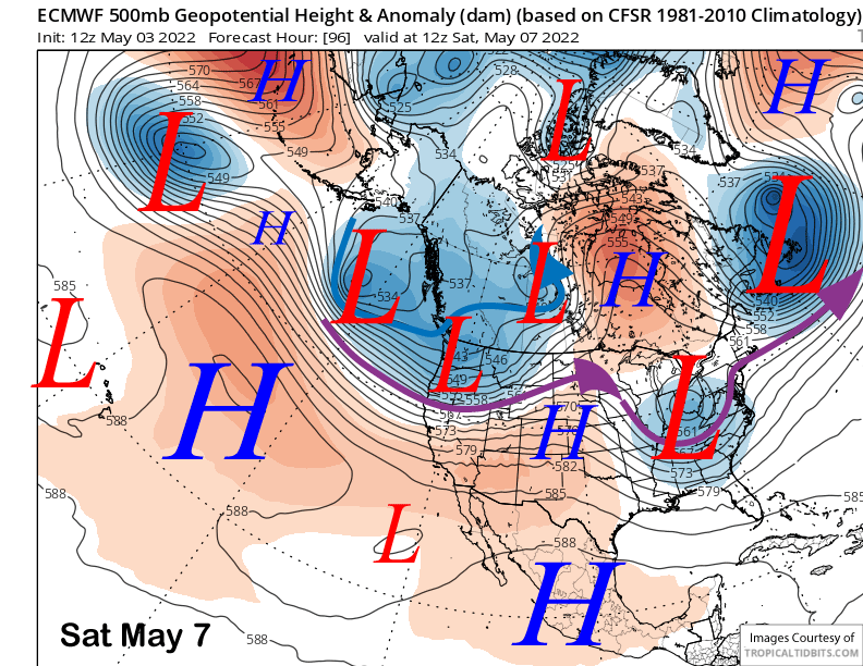
Slightly cooler temps continue Friday and especially Saturday when a trough of low pressure moves into NorCal (image below). Snow may firm up a bit up top, but may stay ok on the lower part of what is still open on the mountain. Winds will increase Thursday and Friday somewhat as well and remain breezy Saturday.
Long Range (Days 5+):
The longer-range guidance is showing a return to winter by Sunday including a good chance for low-end powder conditions by Monday. May powder is not that uncommon with 15 years out of the past 50 having observed at least 10” of snowfall and 7 of those years had two feet or more. And the second driest season on record (2014-15) had the second largest May snowfall total (28”). So a dry season doesn’t mean a dry end to the season.
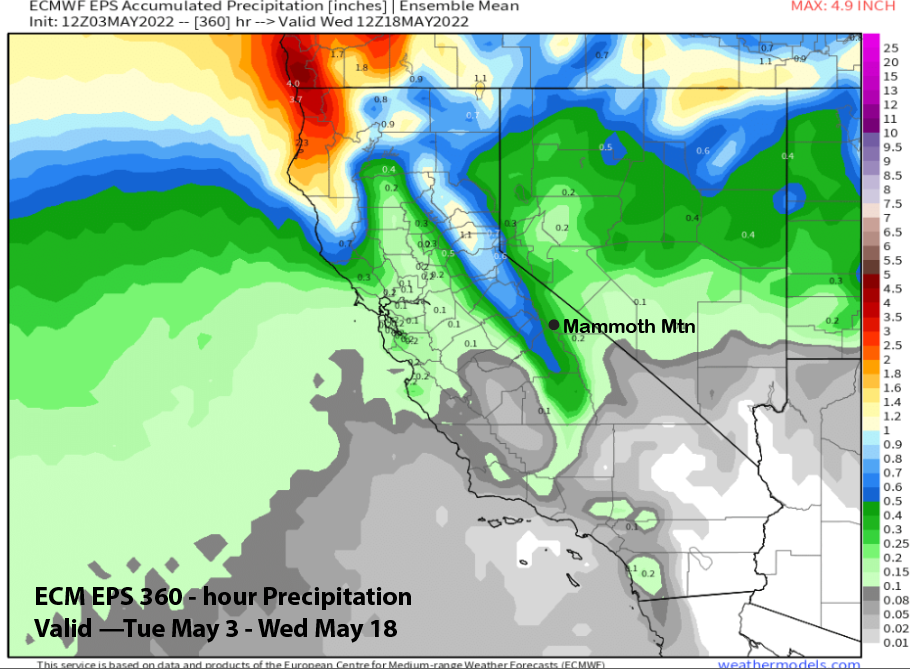
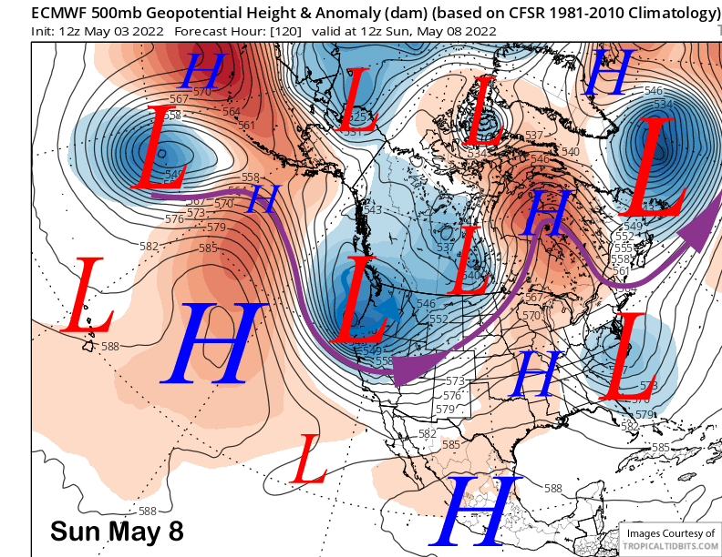
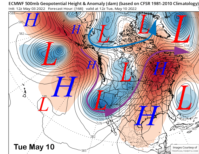
The ECM model (image below) and others are in general agreement that a unseasonably deep trough of low pressure will develop along the West Coast and southward into CA on Sunday with a strong short wave moving through CA in the process. This will mean colder and winter-like temperatures by Sunday and Monday in addition to very strong winds Sunday during the day that could shut down most of the lifts.
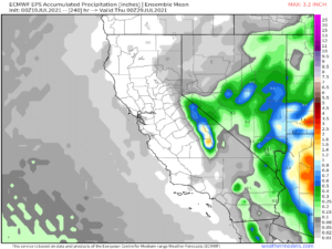
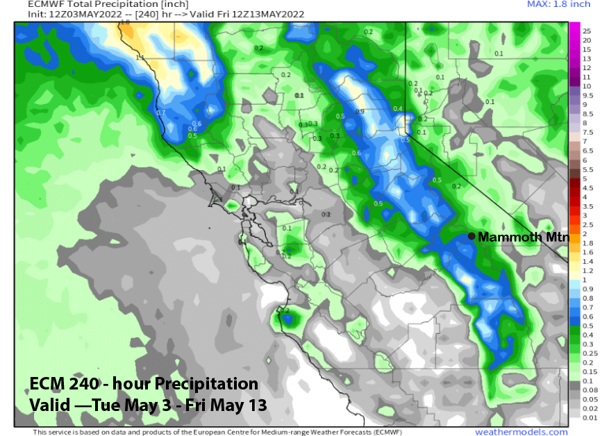
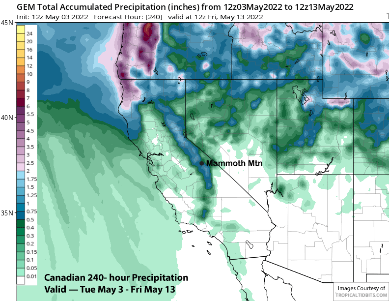
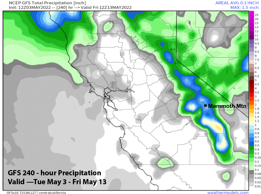
It could also mean enough snowfall for low-end powder conditions with the ECM showing about 0.50” liquid (image below), the Canadian slightly more (two images below) and the GFS the wettest at around 0.75” (three images below). Timing for the snowfall would be Sunday afternoon and night with any potential powder day on Monday when light snowfall may continue at times.
That is because the models don’t move the upper low eastward out of CA (ECM below) until mid-week next week. So there could be continued light snow showers, primarily during the afternoon, though Tuesday, and a slight chance into Wednesday too. The GFS ensemble mean then favors the trough to move eastward (image below) by the end of the week.
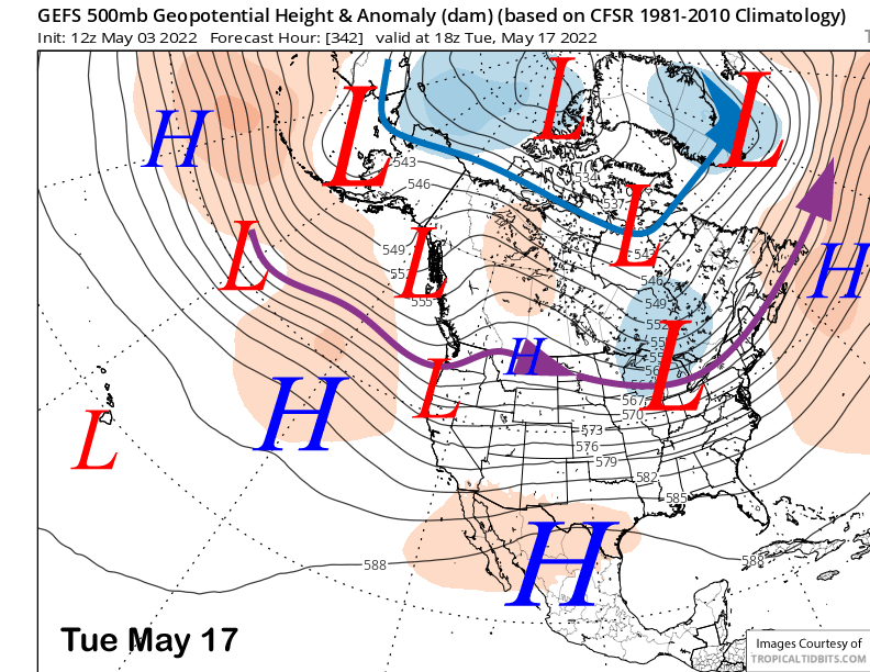
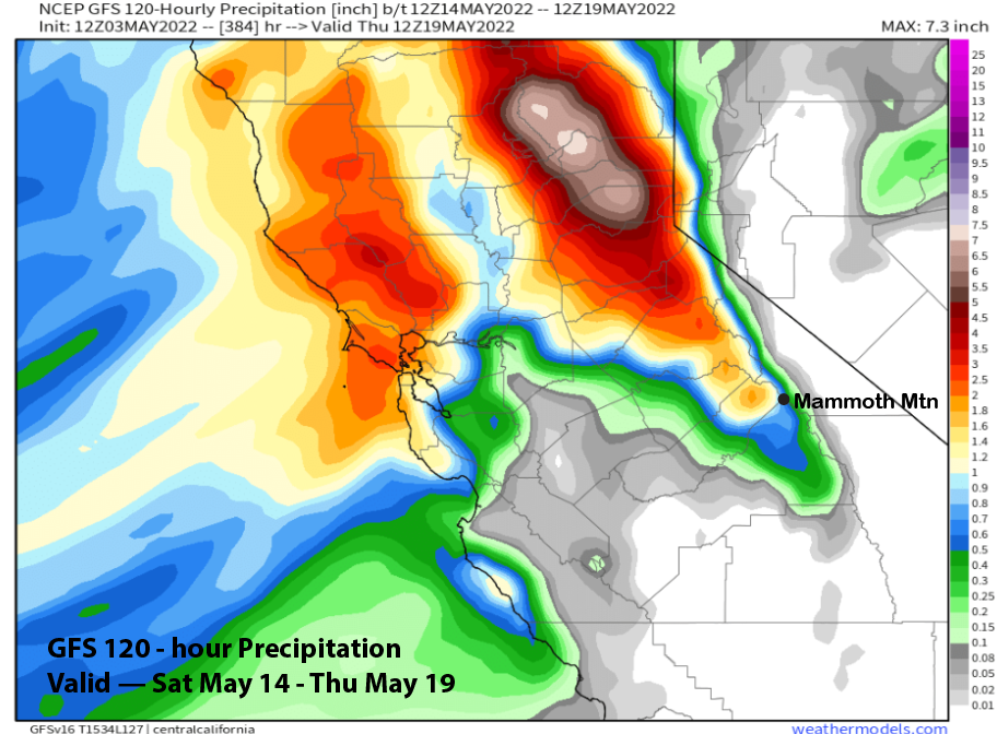
The longer range fantasy guidance is only interesting because the latest 12Z run of GFS operational model is showing a very deep trough off/along the West Coast and the jet stream pointing eastward into CA (image below). It keeps the heaviest precipitation in the N. Sierra, but still has over an inch of liquid for Mammoth (two images below) that could easily translate to a foot.
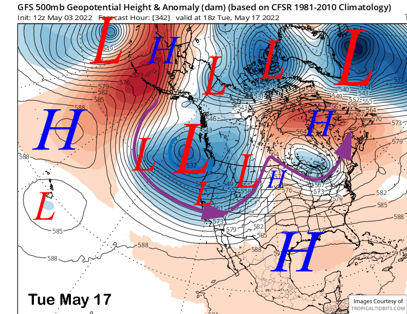
This solution, however, is not supported at all by the GFS ensemble mean (image below) that is only showing a weak trough along the West Coast and into CA. Maybe the model is onto something, but more likely it is out to lunch. The ECM EPS is also not showing much with the precipitation forecast showing most of the rain/snow falling with the Sunday-Tuesday event. Regardless, it appears there may be another chance for a powder day(s) next week. WG