Powder Forecast – Tuesday December 13th, 2022
Ted Schlaepfer CCM —- Mammoth Mountain WeatherGuy
Snowfall forecasts are valid at the Sesame snow course (Main Lodge) for the prior 24 hours as reported in the 6-7 AM morning snow report.
**Snowfall forecast confidence ranges from very low (1) to very high (5)
Wed 12/14 = 0”
Thu 12/15 = 0”
Fri 12/16 = 0”
Sat 12/17 = 0”
Sun 12/18 = 0”
Mon 12/19 = 0”
Tue 12/20 = 0 – 3”
Wed – Fri 12/21 – 12/23 = 0 – 3”
December Snowfall = 77”
December Forecast = 85 – 95”
Detailed 4-day Snowfall Forecast:
Wed 12/14 through Sat 12/17 – No snowfall expected all days
Forecast Summary:
Short Term (Days 1 – 4):
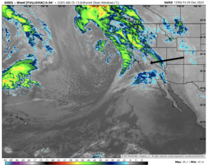
The current infrared satellite image (below) shows weak high pressure having built into the state in the wake of the passage of the storm system over the weekend. A low pressure system off the coast will spit clouds over the state around mid-week, otherwise fair and dry weather is expected.
Models keep a weak ridge over CA through the rest of the week (image below) and into next week for continued dry weather. Under weak northeast flow, temperatures should be seasonable or seasonably cold and conditions great. Winds look relatively light too.
Long Range (Days 5+)
The longer-range guidance is generally not in agreement in the extended time frames, but for the most part, favors dry weather over powder days.
The models are in agreement that an upper-level trough will form over the PacNW early next week with the amplitude of that trough still very uncertain. The Canadian (image below) has the deepest solution and moves a short-wave into the base of the trough from the eastern Pacific around Monday next week resulting in a light/moderate event.
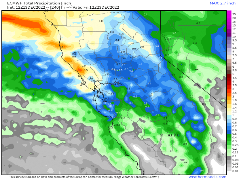
The ECM has the next deepest trough (image below), but has the undercutting short-wave weaker versus the ECM and doesn’t generate any snowfall with its passage. The GFS is the weakest and keep the upper trough mostly confined to Washington/British Columbia and is also dry.
So there is slight chance for a storm early next week with a better chance for continued dry weather. The latest ECM EPS is only showing about a tenth of an inch of precipitation for early next week as most of the ensembles are dry.
The ECM is more aggressive moving that upper-trough southward toward the end of the next week and has a very deep low moving into the interior West (image below). And it is also forecasting decent snowfall amounts during its passage southward too (two images below), enough for powder conditions.
However, the other models have that deep trough weaker and much farther westward with the Canadian showing a very strong ridge or opposite of the ECM. Further, both the GFS ensemble and ECM EPS favor ridging like the operational models, suggesting that the ECM run is an outlier solution.
The fantasy range of the models are mostly in agreement that a ridge will build in the West and a trough in the East. This has been in the forecast for awhile and it looks like it may come to fruition by the last part of the month (image below).
The one fly on the ointment is the GFS ensemble that shows a chance for a westerly breakthrough around Christmas (image below). Currently, the jet stream (purple arrow) is too far northward for a significant storm in Mammoth. But it is a long ways out, and that forecast could change.
Otherwise, it looks like we a going into a long-standing dry period that may continue into early January. The pattern for January looks eerily similar to last January and some climatologists are saying there could be another Sudden Stratospheric Warming event early in the month, just like what occurred last January 2022.
Now will this mean that we are in for a repeat record dry January through March? Probably not. While most of the oceanic indexes are similar to last year including the ONI, MEI, PDO, and AMO, the sub-seasonal forcing will likely be different including the phase/magnitude MJO and how it interacts with a positive QBO versus a negative QBO from last year (studies have shown a different response). Thus, just a normal winter dry spell, hopefully not too long. WG