Powder Forecast – Tuesday January 10th, 2023
Ted Schlaepfer CCM —- Mammoth Mountain WeatherGuy
Snowfall forecasts are valid at the Sesame snow course (Main Lodge) for the prior 24 hours as reported in the 6-7 AM morning snow report.
**Snowfall forecast confidence ranges from very low (1) to very high (5)
Wed 1/11 = 20 – 24” (H20 = 2.00” – 2.25”) **4
Thu 1/12 = 2 – 3” (H20 = 0.25” – 0.35”) **3
Fri 1/13 = 0”
Sat 1/14 = 4 – 6” (H20 = 0.45” – 0.65”) **2
Sun 1/15 = 12 – 20”
Mon 1/16 = 3 – 6”
Tue 1/17 = 10 – 15”
Wed – Fri 1/18 – 1/20 = 4 – 6”
January Snowfall = 133”
January Forecast = 180 – 200”
Next update on Saturday
Detailed 4-day Snowfall Forecast
Wed 1/11 – Snowfall develops again around midday and continues through the evening, ending overnight. Accumulations 2 – 3” by Wednesday AM, 3”+ up top
Thu 1/12 – No snowfall expected
Fri 1/13 – Dry during the morning and into midday, then snowfall develops during the afternoon or evening and continues overnight. Accumulations 4 – 6” by Saturday AM
Sat 1/14 – Light snow showers are possible during the morning, then moderate to heavy snowfall increases during the afternoon and continues overnight. Accumulations 12 – 20” by Sunday AM, 24”+ up top
Forecast Summary:
Short Term (Days 1 – 4):
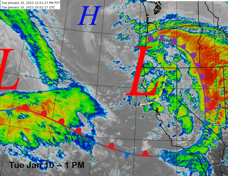
The current infrared satellite image (below) shows the latest storm system moving into the state with the next band of heavy snow now moving into Mammoth.
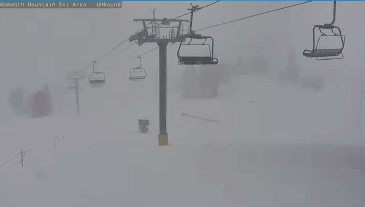
Web cam grabs from earlier today show it puking snowfall on the mountain (image below). But there will be no storm riding today as the mountain closed to due excessive snowfall and storminess.
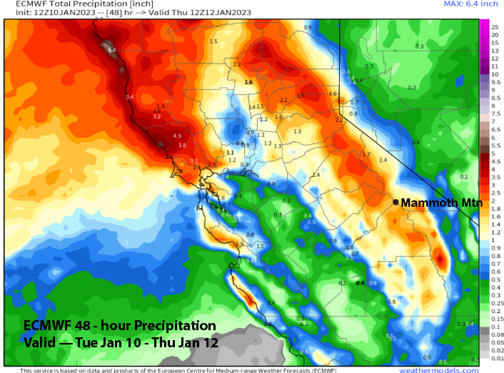
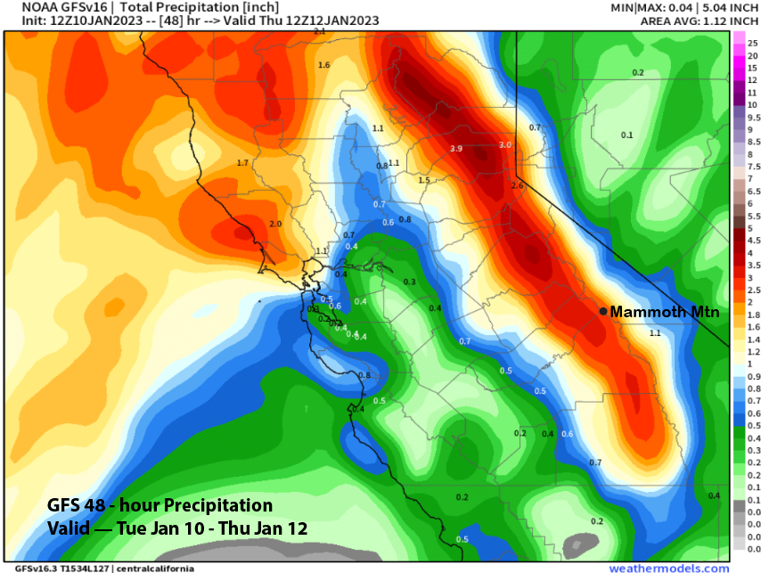
Snowfall will continue through this evening before ending overnight. However, the system far offshore on the satellite image will produce another round of mostly light snowfall tomorrow afternoon and evening. Model Quantitative Precipitation Forecast (QPF) from the ECM model shows almost 2” more liquid through tomorrow (image below) while the GFS is showing slightly more at almost 3” (image below). Therefore, up to two more feet of snowfall expected at Main today and then a few inches more tomorrow afternoon/evening.
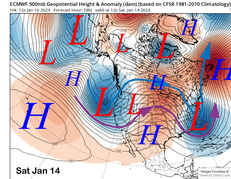
A break from the storminess is forecast for Thursday and possibly into Friday as well. The models then move the next storm system into the state by Saturday (image below) and into Sunday for more moderate to heavy snowfall. The GFS model is a little faster and develops snowfall earlier on Friday, so there is a chance that Friday could be a storm riding day.
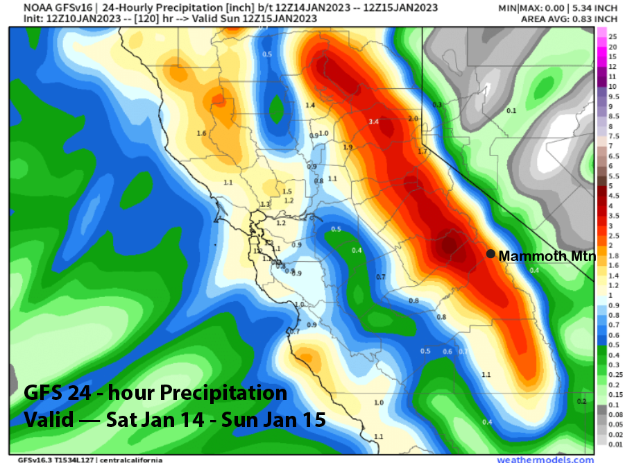
Forecast favors at least another foot of snowfall and possibly two feet. GFS is showing about 2.5” liquid from Saturday AM into Sunday (image below) and that is when the heaviest snowfall is expected. Snow showers will probably continue Sunday ahead of the next storm with only accumulation on Sunday light.
Long Range (Days 5+)
The longer-range guidance is still showing the storm cycle continuing through early or maybe the middle part of next week before the cycle finally ends by the end of the week.
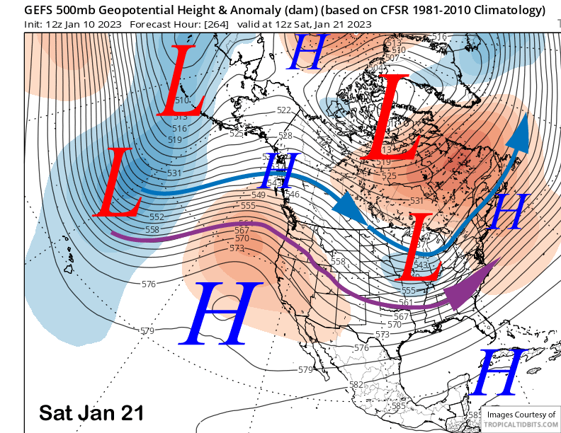
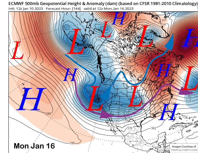
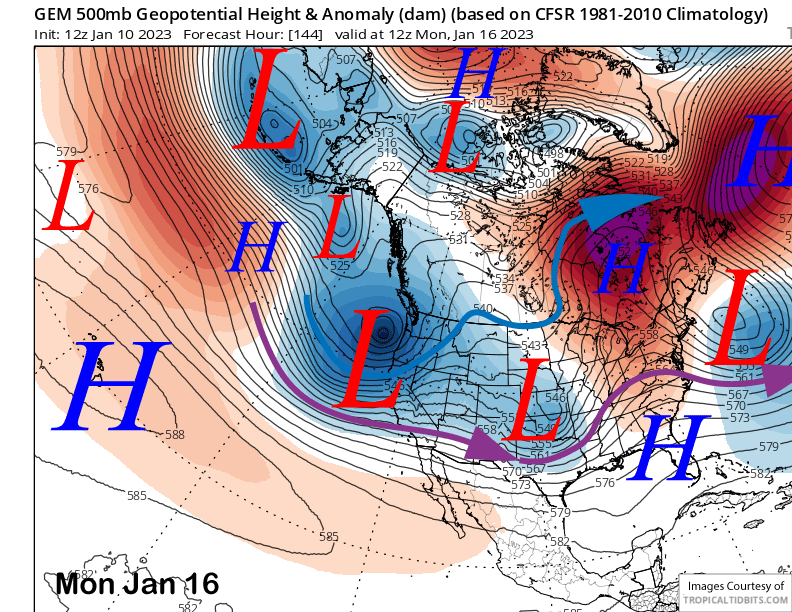
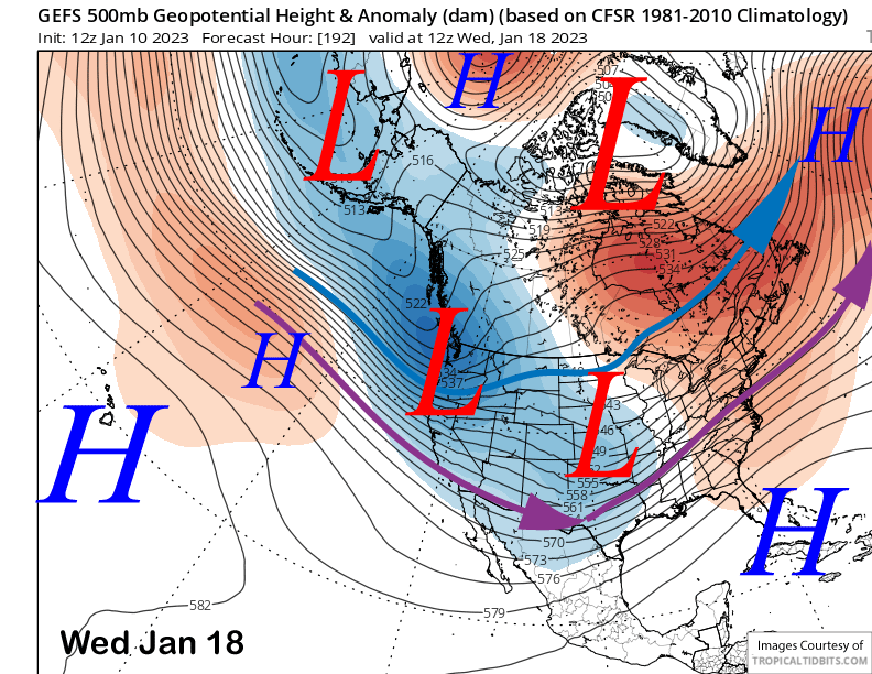
The latest run of the ECM model moves the next deep short-wave trough into CA around Monday next week (image below) and its latest run is moving the storm mostly into SoCal. The other models favor a more northward track with the storm system with the Canadian (two images below) and GFS favoring the jet stream core (area between the blue and purple arrows) to be more aligned into the Central and Southern Sierra.
A trailing system may follow on Tue/Wed with the GFS the deeper model, while the ECM and Canadian keep the precipitation across NorCal and Mammoth dry. The GFS ensemble favors a trough (image below), just not as deep as the 12z operational run.
And thus, QPF amounts from the models differ substantially with the GFS the wettest model and the ECM the driest. The GFS is showing nearly 4” liquid more on Monday through Wednesday while the ECM is only showing about an inch. The Canadian has about 2.5” liquid.
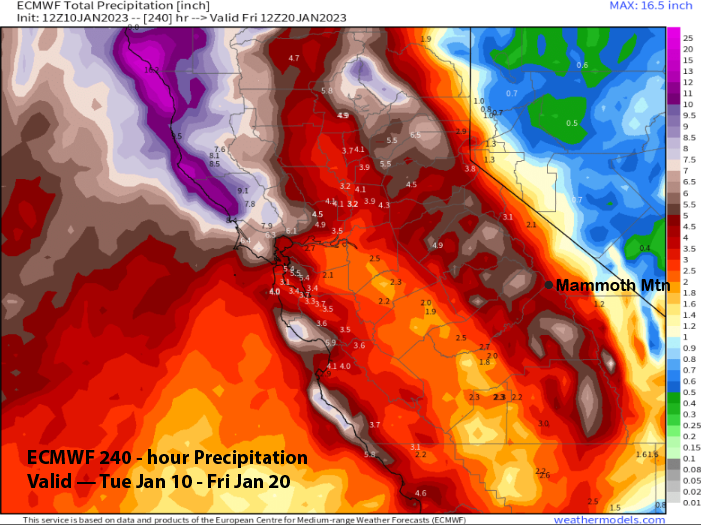
Overall, the GFS model is much wetter versus the ECM model over the 10-day period and has nearly three times the amounts at about 12” liquid (image below) versus the ECM at only around 4” from the ECM (image below). The Canadian is in between the two models at around 8” liquid. Forecast followed the ECM mean that is closer to the Canadian.

The longer-range guidance is then favoring the storm cycle to end toward the end of next week as high pressure ridging builds into the state and the long-wave trough shifts eastward (image below). The dry weather may then last for the rest of the month allowing the town/resort to continue to dig out. Next update on Saturday. WG