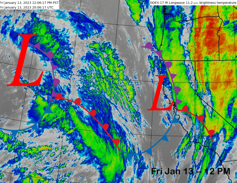
Powder Forecast – Friday January 13th, 2023
Ted Schlaepfer CCM —- Mammoth Mountain WeatherGuy
Snowfall forecasts are valid at the Sesame snow course (Main Lodge) for the prior 24 hours as reported in the 6-7 AM morning snow report.
**Snowfall forecast confidence ranges from very low (1) to very high (5)
Sat 1/14 = 5 – 6” (H20 = 0.50” – 0.65”) **4
Sun 1/15 = 18 – 22” (H20 = 1.75” – 2.25”) **3
Mon 1/16 = 4 – 6” (H20 = 0.40” – 0.60”) **3
Tue 1/17 = 15 – 18” (H20 = 1.50” – 1.75”) **3
Wed 1/18 = 0”
Thu 1/19 = 0 – 3”
Fri 1/20 = 0”
Sat – Mon 1/21 – 1/23 = 0 – 3”
January Snowfall = 133”
January Forecast = 180 – 200”
Detailed 4-day Snowfall Forecast
Sat 1/14 – Snowfall intensity increases during the day, becoming heavy during the afternoon and evening, then decreases overnight. Accumulations 18 – 24” by Sunday AM, 24”+ up top
Sun 1/15 – Light snow showers or flurries are possible during the day and evening, then snowfall increases late at night. Accumulations 4 – 6” by Monday AM, 6”+ up top
Mon 1/16 –Snowfall, heavy at times during the day, decreases evening, and then ends overnight. Accumulations 15 – 20” by Tuesday AM, ~24”+ up top
Tue 1/17 – No snowfall expected
Forecast Summary:
Short Term (Days 1 – 4):
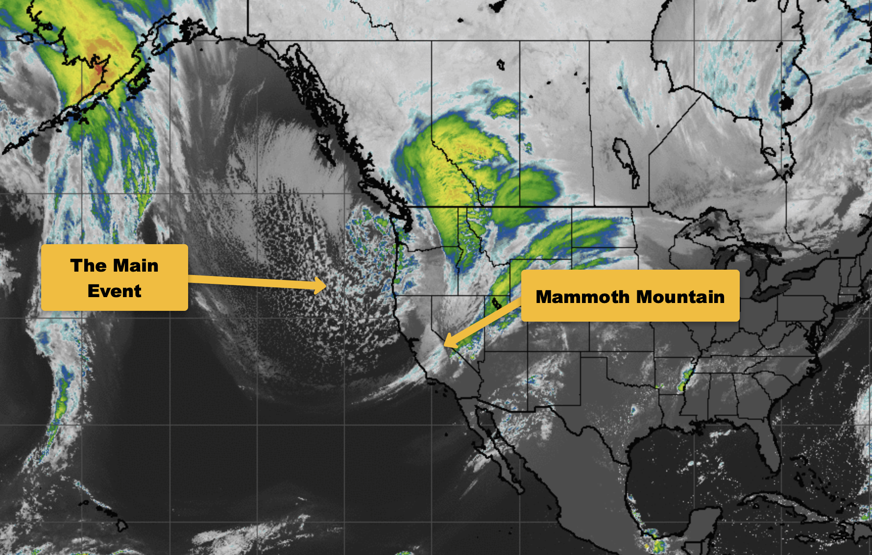
The current infrared satellite image (below) shows the next storm system moving into the state and a stronger developing storm off the coast that is moving into the eastern Pacific Ocean.
Light to moderate snowfall will start this afternoon and continue overnight with maybe up to 6 inches of snow at Main by tomorrow morning. This storm will be the weakest of the last three systems during this major storm cycle that is pummeling the state.
The ECM model quickly moves the next storm into the state tomorrow (image below) and snowfall is forecast to increase during the day and become heavy during the afternoon and evening hours. Snowfall should then decrease overnight with just light snow showers or flurries expected on Sunday.
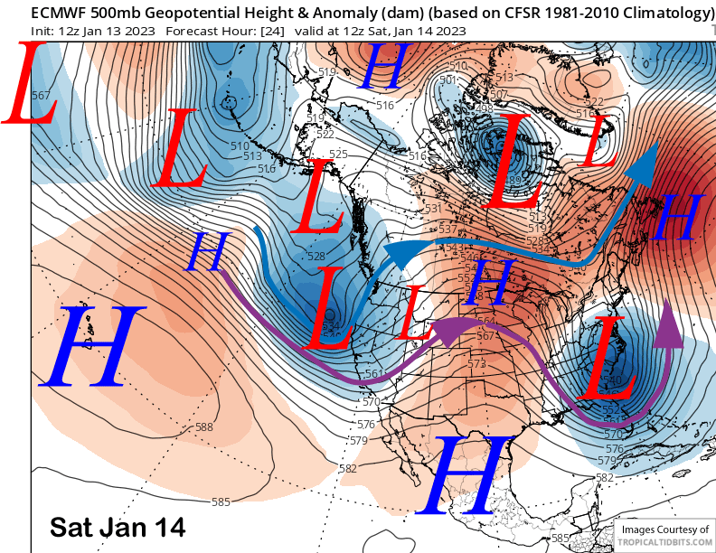
Snow levels with this storm will be around 5000 feet, lowering to near 4000-4500 feet on Saturday night as the storm is winding down. Snow quality won’t be as wet/heavy (Sierra cement) as recent storms, but not exactly light powder either. Good chance that 20” will fall at Main with likely two feet or more up top. Saturday will also be a storm riding day and with winds not looking super strong, there is decent chance that Ch 22 may run all day for free powder refills.
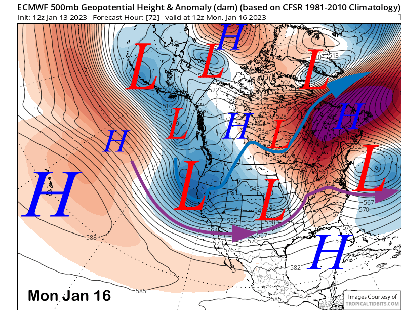
The final storm in the major storm cycle that started the day after Christmas will then move into Mammoth on Monday (image below) resulting in more moderate to heavy snowfall before ending Monday night. This system will be a bit colder than the Saturday storm and snowfall quality possibly a bit lighter, but again, not super fluffy. Dry weather likely returns Tuesday.
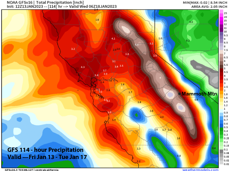
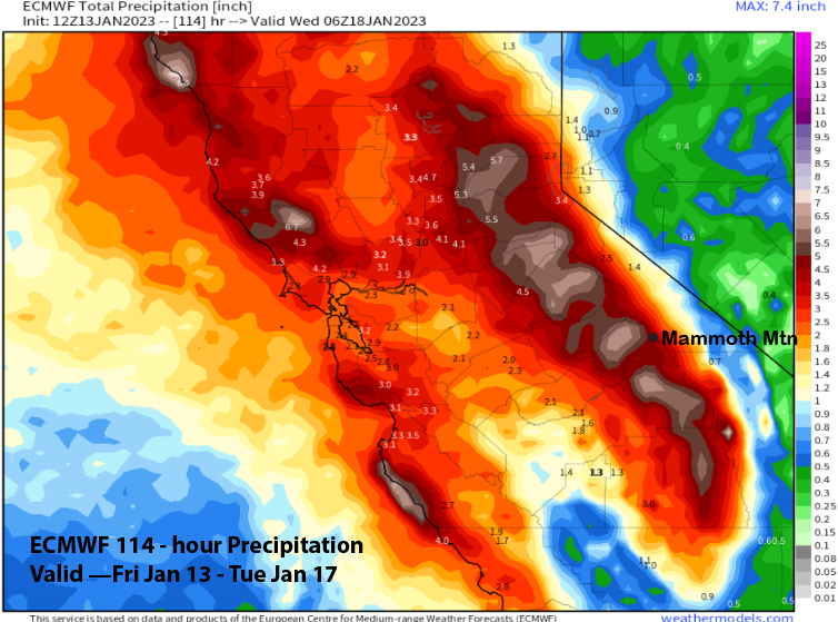
Quantitative Precipitation Forecasts (QPF) for the three storms is fairly close between the models with the GFS showing about 5” liquid (image below) and the ECM (two images below) around 4.5”. The Canadian model is also showing about 5”. Thus, another 3 feet of snowfall for Main is likely by Tuesday and maybe 4 feet. Four to five feet of snowfall is expected up top.
Long Range (Days 5+)
The longer-range guidance is still favoring the storm cycle to end next week with dry weather forecast for the end of the week and through the following weekend. It was certainly one of the biggest and longest storm cycles I have ever seen/forecast and Mammoth is currently sitting on a record snowpack for mid-January.
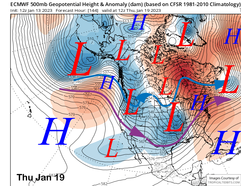
The guidance is showing one more short-wave trough passage around Thursday next week (image below) and the models are favoring it to be an inside slider type weather system. That means it will be moisture starved and only light snowfall is expected, if any at all, with just colder temperatures and some northerly winds a better scenario.
High pressure is then expected to build into the state next Friday and possibly remain in place through the following weekend for at least a brief stretch of dry weather. However, the guidance is not exactly in agreement.
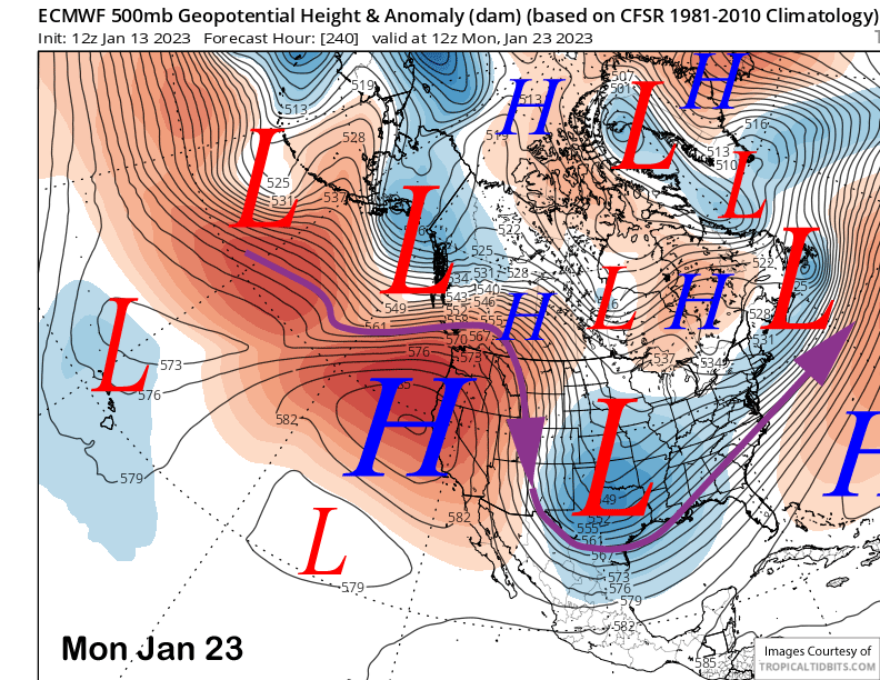
The 12z run of the ECM model (image below) strengthens the ridge into Monday next week for continued fair and warmer weather, but the GFS (two images below) is totally different and moves a deep upper low southward from interior Canada (another inside slider) and parks it over southeast California.
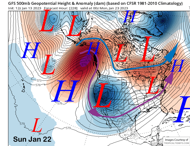
The GFS solution would mean very cold temperatures in addition to light snowfall and this snowfall would be the light and fluffy type at 20-30”:1” snow ratios. The Canadian model solution shows a weaker inside slider and positions it a bit farther eastward.
The GFS ensemble is closer to the Canadian solution while the ECM EPS is fairly good agreement with the 12z operational run showing a robust high pressure ridge. Forecast favors a blend of the GFS and ECM EPS that keeps the slider farther eastward and closer to the Canadian solution.
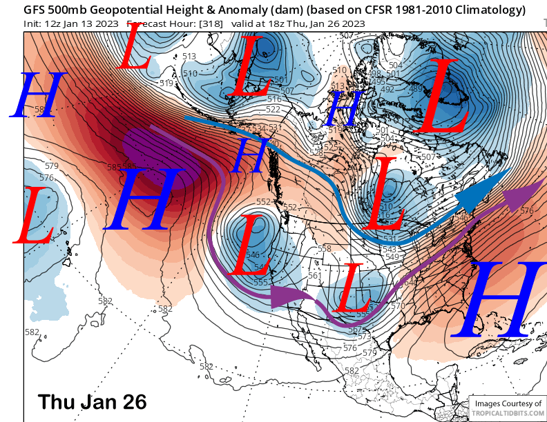
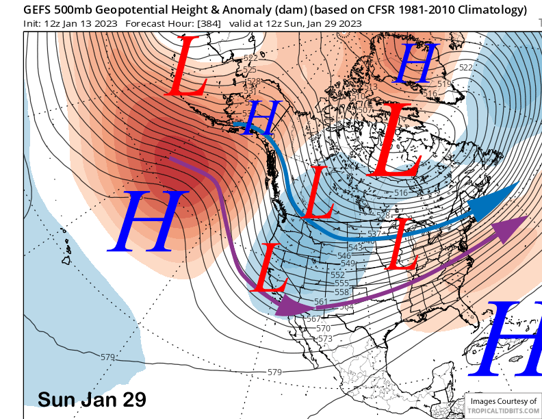
In the fantasy range, the GFS tries to move another upper-level trough southward into CA, this time with more over-water trajectory (image below).That could mean some light/moderate snowfall. However, the ensemble mean doesn’t have the long-wave trough that far west, although it is favoring retrogression of the trough back westward toward the end of the month.
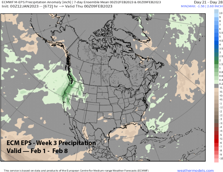
Based on the GFS ensemble mean (image below) that is showing retrogression and the latest ECM EPS forecast from yesterday, the next decent chance for a storm(s) probably won’t be until the end of the month or early February.
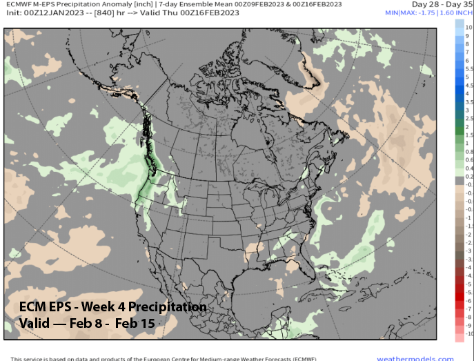
The ECM EPS is showing above normal precipitation (image below) in week 3 or the first week of February and keeps average to slightly above in the forecast through week 4 (two images below) or the second week of February. So, unless there is a surprise, a powder day break is looking likely for maybe 10-14 days to end the month. Powder and storm riding days may then return in February. If we want to ski into August, we need more storms this winter. WG