mammoth mountain weather forecast and outlook

Mammoth Mountain Weather Forecast & Discussion

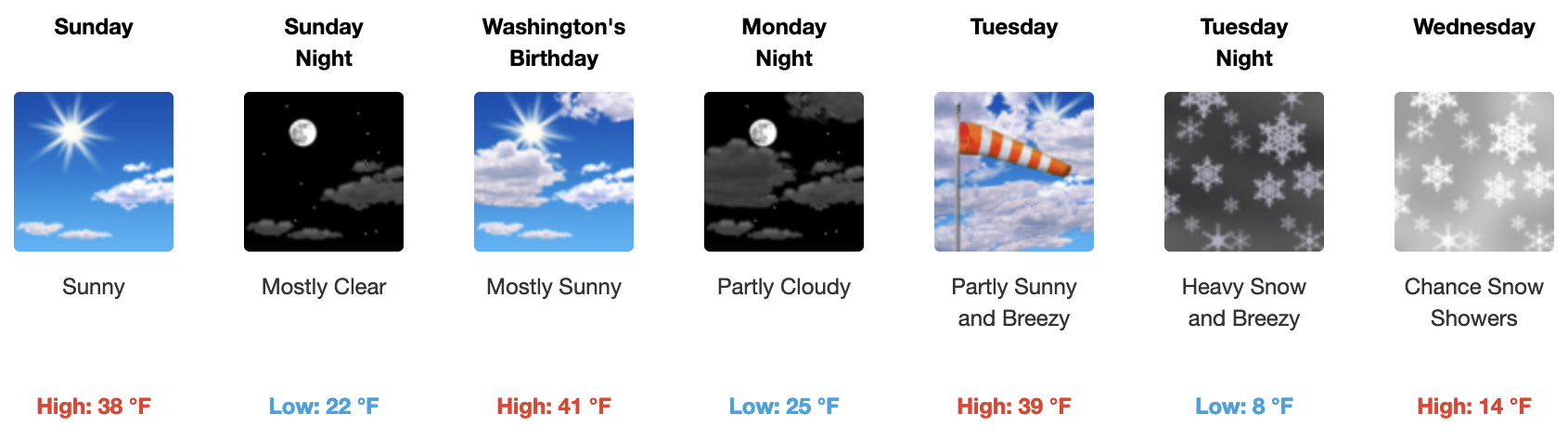
February 18th, 2023 @ 9 AM – The Holiday weekend should be a good one with much warmer daytime highs along with pt cloudy skies and a light SW wind flow.

If you’re going to be out on the hill on Saturday and Sunday expect mostly sunny skies with temperatures at 8:30 AM in the lower 20s. By mid-day temperatures will be up into the upper 30s to lower 40s. The wind forecast has the wind out of the NE with wind speeds on the lower hill at 5-10 MPH with mid and upper mountain winds in the 10-15 MPH range with gusts to 20-25 over top ridges.

Presidents Day also looks great with sunny skies and highs jumping into the mid-40s around Main Lodge.

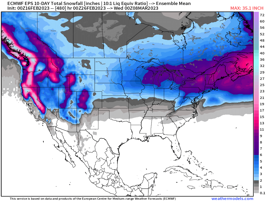
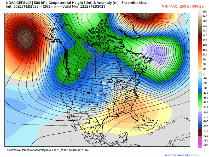
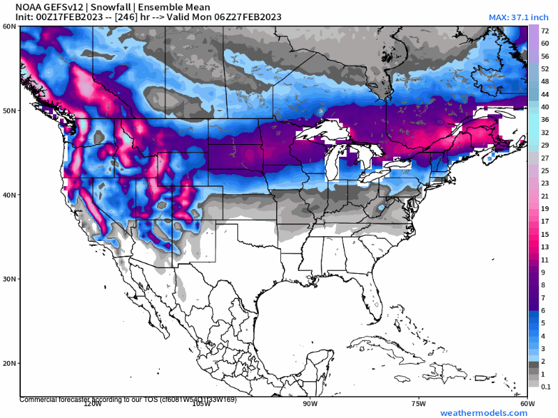
Beyond Monday, the Next Storm Cycle will slowly start ramping up, read down the page for the extended outlook.

Snowman

2023 02 18 08 48 01Snowfall.final


animate

Mammoth Mountain 5-10-Day Extended Outlook

2-18-23 – As of this post, you can expect a new series of storms to be moving through the Mammoth Mountain area starting late next Tuesday into Friday with a break next weekend and then more snow the following week possibly into early March.

Looking at the newest data this morning this new weather pattern looks to be capable of bringing in some epic light and dry powder up on Mammoth Mountain. Over snowfall accumulations will be on the lower levels with 1-2 feet of snow possible in the 5-10 Day outlook period.

With all the cold air in place and with the track these systems will be taking, you can expect some light and dry Alta-like powder out on the mountain off the groomed runs. The groomers will turn to a nice soft and quiet mid winter packed powder.

Snowman

9 km ECMWF Global Pressure North America 500 hPa Height Anom2
5-10 Day - ECMWF 500 Height Anomaly
9 km ECMWF USA Cities Central California Snowfall2 1
5-10 Day - ECMWF Snowfall

11-16 Day Super Fantasy Long-Range Discussion

2-18-23 – The troughing off the west coast continues to show up right through day 16 on the EPS model below. More cold powder chances would be in the offering. Yes, it’s way too FAR out to nail down the details and any amounts. 

14 km EPS Global North America 500 hPa Height Anom3 6
11-16 Day ECMWF EPS 500 Height Anomaly
14 km EPS USA California 24 h Precipitation1 2
11-16 Day ECMWF EPS 500 Height Anomaly

Extreme Fantasy Outlook Model Data

2-18-23 – Here is the updated data for this Saturday morning. The EPS keeps winter going into March 8th and then precipitation chances die off quickly. The GEFS keeps the snow show going at times right up to the last day of winter on March 21st, 2023. Please note none of the fantasy outlooks have a big AR hook up just nice cold air with light to moderate amounts of fresh powder. 

14 km EPS 46 DAYS North America 5 day Avg 500Z Anom1
ECMWF EPS 500 Height Anomaly February 27th to March 21st
eps snow by10 m01 conus 240
10 Day Day Snowfall ECMWF EPS 500 Height Anomaly
eps snow by10 m01 conus 480
11-20 Day Snowfall ECMWF EPS
GEFS Ensembles North America 500 hPa Height Anom2 2
GEFS High Anopmply Chart February 27th to March 21st
GEFS Ensembles United States Snowfall4 1
GEFS Snowfall February 27th to March 21st
2023 02 16 12 08 23
ENSO Outlook
2023 01 14 11 32 50
2023 01 14 11 33 25
2023 01 14 11 33 55
2023 01 14 11 35 02

Mammoth Mountain and Eastern Sierra Weather Posts