Powder Forecast – Friday February 24th, 2023
Ted Schlaepfer CCM —- Mammoth Mountain WeatherGuy
Snowfall forecasts are valid at the Sesame snow course (Main Lodge) for the prior 24 hours as reported in the 6-7 AM morning snow report.
**Snowfall forecast confidence ranges from very low (1) to very high (5)
Sat 2/25 = 32 – 38” (H20 = 2.50” – 3.00”)**4
Sun 2/26 = 11 – 14” (H20 = 1.00” – 1.25”)**3
Mon 2/27 = 6 – 9” (H20 = 0.40” – 0.60”)**3
Tue 2/28 = 15 – 20” (H20 = 1.25” – 1.75”)**3
Wed 3/1 = 9 – 12”
Thu 3/2 = 3 – 9”
Fri 3/3 = 0”
Sat – Mon 3/4 – 3/6 = 6 – 20”
February Snowfall = 37”
February Forecast = 90 – 100”
Detailed 4-day Snowfall Forecast
Sat 2/25 –Snowfall, heavy at times, continues during the day, tapering off overnight into Sunday morning. Accumulations 11 – 14” by Sunday AM and 15”+ up top
Sun 2/26 – Light to moderate snowfall develops late afternoon and continues overnight. Accumulations 6 – 9” by Monday AM and 12”+ up top
Mon 2/27 – Snowfall increasing in intensity during the afternoon and night hours before decreasing toward dawn. Accumulations 15 – 20” by Tuesday AM and 24”+ up top
Tue 2/28 – Snow showers continue at times during the day before increasing again early Wednesday. Accumulations 6 – 12” by Wednesday AM, 15”+ up top
Forecast Summary:
Short Term (Days 1 – 4):
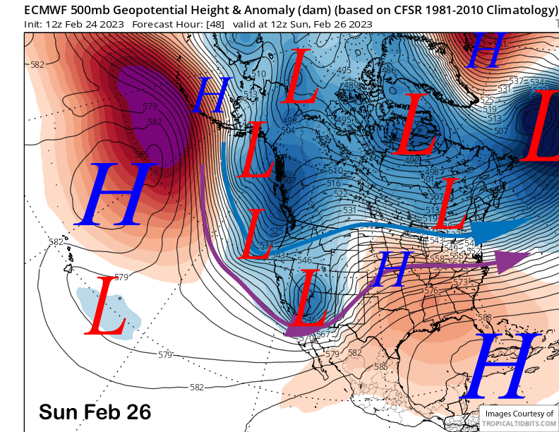
The current infrared satellite image (below) this afternoon shows deep upper-level low pressure system centered off the Central California coast and a strong frontal system stretching across most of the southern two-thirds of the state.
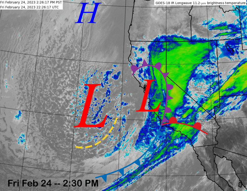
The storm is going to slowly move southward and eastward through Saturday before exiting the state on early Sunday (image below) with the next short-wave poised to quickly move into the state on its heels. That means there will be nearly 36 more straight hours of snowfall in Mammoth as of this writing before the snowfall briefly ends Sunday during the day.
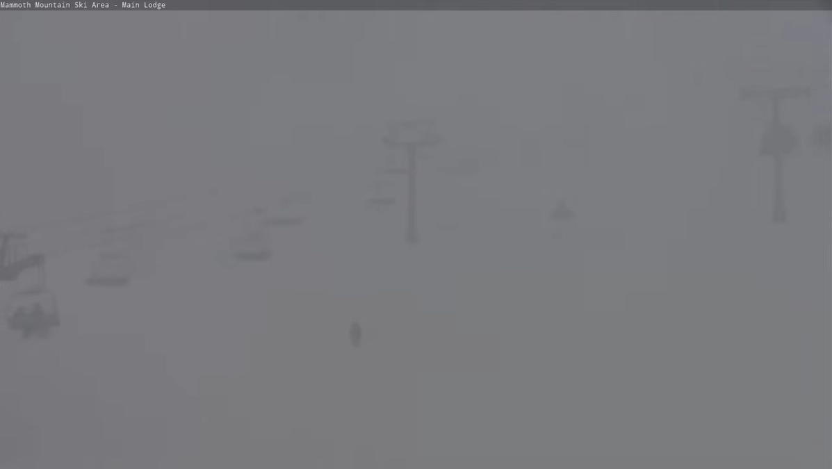
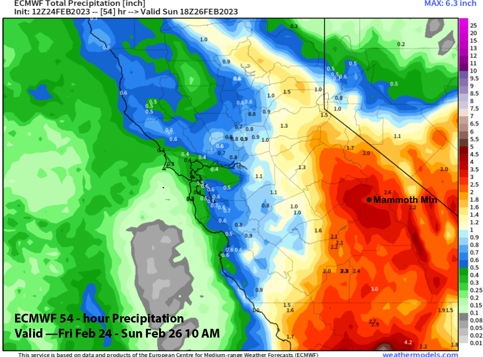
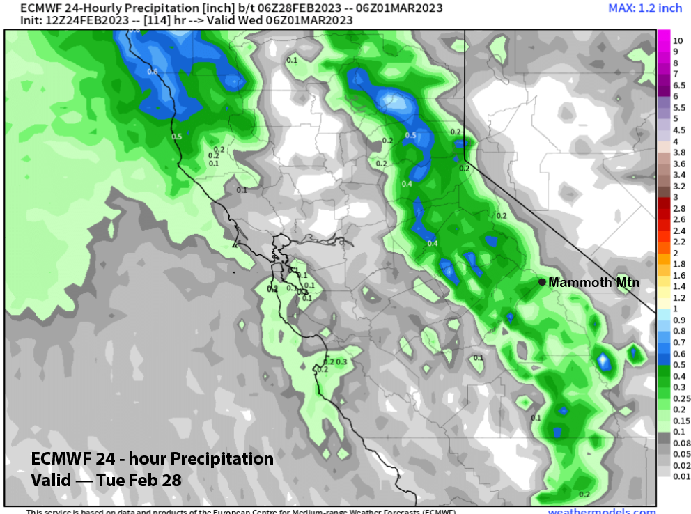
And is it currently dumping with web cams showing very low visibility out of Main Lodge (image below). That view won’t change much until Sunday with the ECM model favoring more than 3” liquid (image below) until then and that is likely a bit too low. Under the continued cold temps and low snow levels, snow ratios are expected to be in the 12”:1” range or higher.
Forecast is calling for about 3 feet at Main of new by tomorrow morning (19” has already fallen today at 4 PM) followed by another foot or so during the day tomorrow and tomorrow night when snowfall intensity will be lower.
Winds tomorrow won’t be strong at all, so Ch 22 and Ch. 25 should run if patrol can get their avy work done. It will be an epic storm riding day tomorrow with deep pow and refills all day. Unfortunately, if you are not already in Mammoth, you likely won’t get here as snowfall is expected on US 395 in the Owens Valley that will likely shut it down or create huge delays (395 is currently shut down north of Bishop).
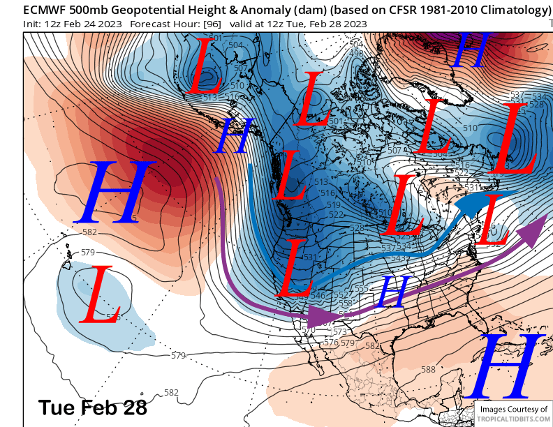
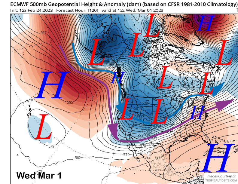
Snowfall, mostly light, starts again on Sunday afternoon and continues through Sunday night. Models are favoring another fairly strong and cold short-wave to then move through the state on Monday/Tuesday (image below) and snowfall should increase in intensity Monday night.
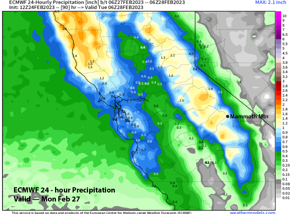
The GFS is a bit farther westward with the trough when it digs southward and thus QPF amounts slightly higher around 2”+ versus the ECM model for Monday (image below) and Tuesday (two images below) that show about 1.5” liquid total for both days.
Models are favoring a trailing short-wave to move through the state next Wednesday (image below) for another round of snowfall before there will likely be a break for a day or two. That short-wave on Wednesday could produce six inches of snowfall and continued powder conditions, and again, the GFS is a bit wetter.
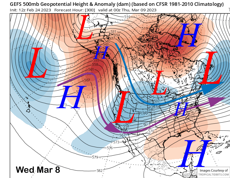
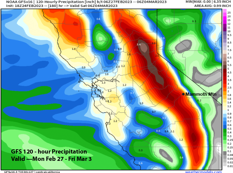
Current forecast leans slightly toward the GFS model (image below) versus the 12z ECM run that is a bit drier versus the ECM mean. Thus, another two feet and likely more is expected to fall on Sunday night through Wednesday and it will be cold-type powder and not Sierra cement as snow levels will mostly stay under 4000 feet. Epic conditions continue as the number of consecutive powders will be seven by next Wednesday.
Long Range (Days 5+)
The longer-range guidance is showing continued storm chances through early next month before a shift in the weather pattern is possible by the second week. But there should be more powder day chances before that occurs.
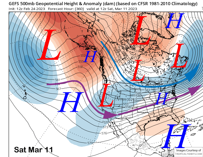
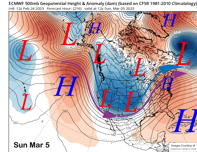
The guidance is not in agreement with the pattern for the following weekend with the ECM 12z deterministic run favoring the passage of a couple high latitude troughs over the weekend (image below). That would produce some snowfall, but not deep powder.
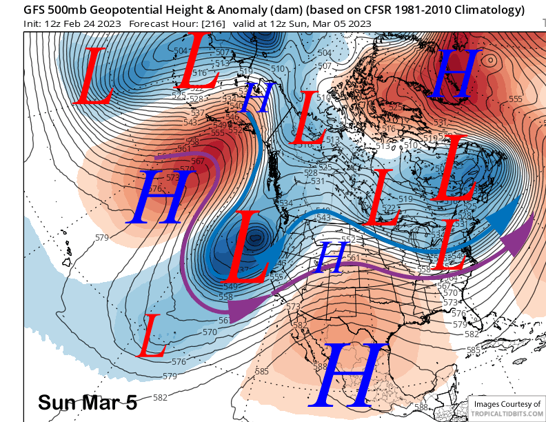
The Canadian model (image below) is different and has a much deeper closed low centered off the Central Coast. It actually keeps most of the precipitation south of Mammoth with only light snowfall. The GFS (two images below) is farthest west with the trough and is the only model that develops a southwest jet.
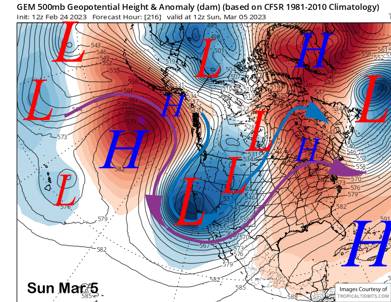
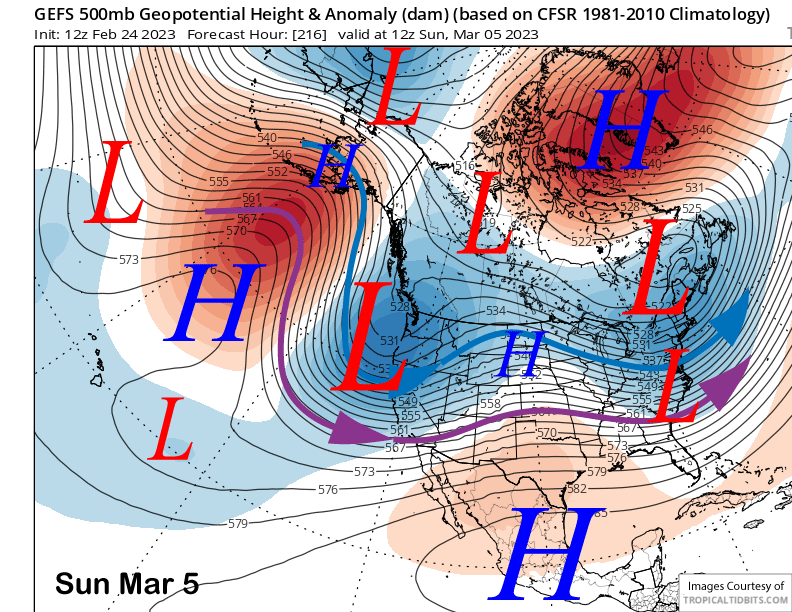
Further, the GFS ensemble (image below) and ECM EPS (two images below) also differ significantly with the GFS much farther westward with the position of the long-wave trough. The GFS solution would be wetter versus the ECM that would be colder and drier. Current forecast favors a blend of the two ensemble system and is low confidence.
The GFS (image below) and ECM both shift the long-wave trough eastward by the middle part of the following week. The ECM mostly keeps it eastward while the GFS returns a weak trough over CA by the following weekend (two images below). That could favor weaker storms while the ECM solution is mostly dry which would not be surprising as storm cycles usually last no longer than 10 days to two weeks. WG