Powder Forecast – Friday March 3rd, 2023
Ted Schlaepfer CCM —- Mammoth Mountain WeatherGuy
Snowfall forecasts are valid at the Sesame snow course (Main Lodge) for the prior 24 hours as reported in the 6-7 AM morning snow report.
**Snowfall forecast confidence ranges from very low (1) to very high (5)
Sat 3/4 = 0”
Sun 3/5 = 10 – 14” (H20 = 1.00” -1.25”)**3
Mon 3/6 = 15 – 20” (H20 = 1.25” -1.50”)**3
Tue 3/7 = 1 – 3” (H20 = 0.10” -0.20”)**3
Wed 3/8 = 0 – 1”
Thu 3/9 = 1 – 3”
Fri 3/10 = 0”
Sat – Mon 3/11 – 3/15 = 0 – 3”
March Snowfall = 27”
March Forecast = 75 – 110”
Detailed 4-day Snowfall Forecast
Sat 3/4 – Snowfall starts during the morning, increases late PM/evening, and continues at times overnight. Accumulations 10 – 14” by Sunday AM and 16”+ up top
Sun 3/5 – Snowfall, heavy at times during the morning, continues through the day and overnight. Accumulations 15 – 20” by Monday AM, 24”+ up top
Mon 3/6 – Mostly light snow showers continue at times during the day before tapering off overnight. Accumulations 1 – 3” by Tuesday AM, 4”+ up top
Tue 3/7 – Probably dry during the day followed by a chance for light snow showers overnight. Accumulations 0 – 1” by Wednesday AM
Forecast Summary:
Short Term (Days 1 – 4):
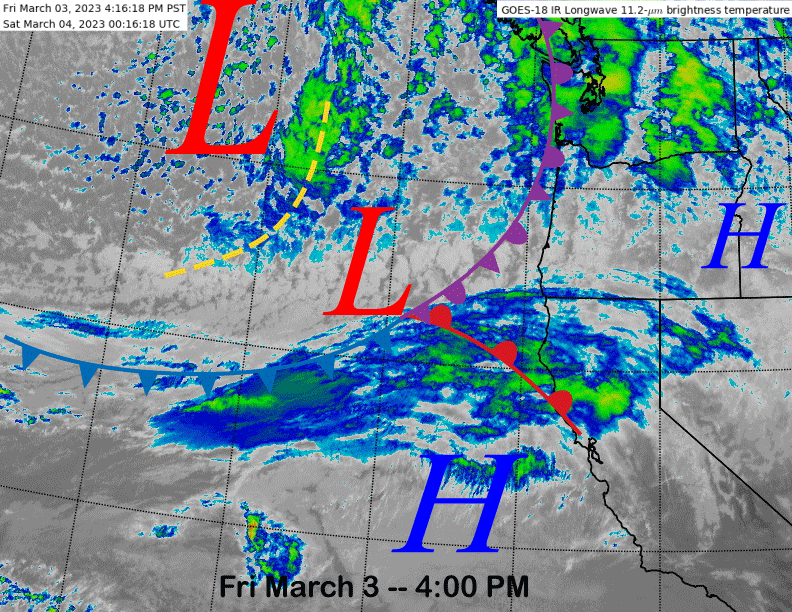
The current infrared satellite image (below) this afternoon shows high clouds moving into northern part of the state ahead of the next storm system to produce heavy snowfall for Mammoth this weekend. The initial cold front will move into Mammoth tomorrow morning with snowfall increasing in intensity during the late afternoon and evening followed by mostly moderate snowfall rates overnight Saturday in the post-frontal environment.
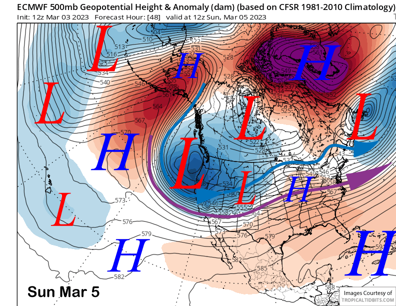
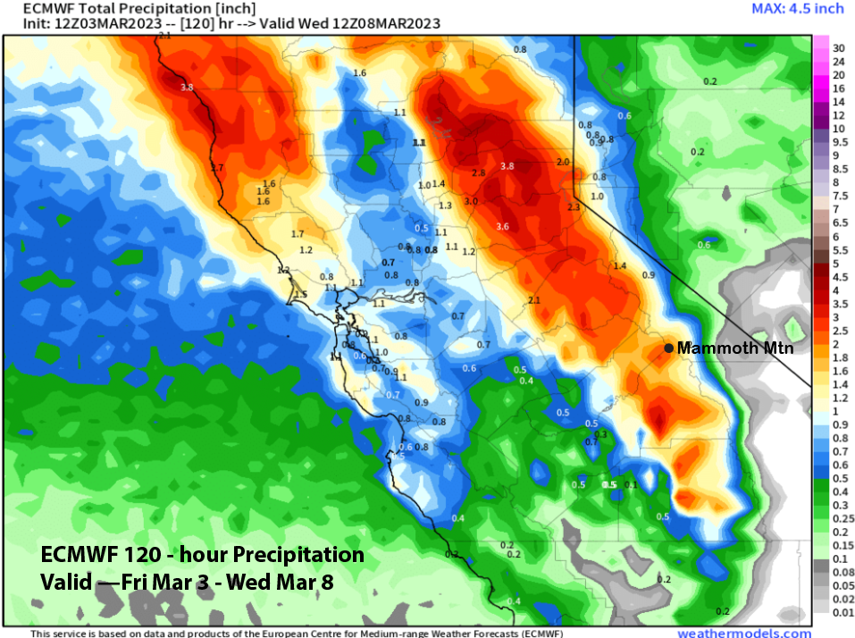
The models (ECM below) drive the upper-level trough southward by early Sunday and that will push another wave of heavier snowfall into Mammoth during the morning hours. Snow, heavy at times, will then continue the rest of the day and overnight into Monday morning. Snow will then turn to showers that will taper off and end by Tuesday morning.
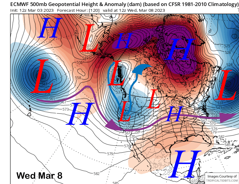
The ECM model (image below) produces another chance for snowfall overnight Tuesday and into Wednesday with the eastward movement of the upper-level trough, but keeps most of the accumulation north of Mammoth. So maybe an inch or two more.
It will be another cold storm with snow levels mostly in the 2500-3000 foot range after starting out near 4k on Saturday. That means more fluffy or drier quality snowfall at 12-15”:1” snowfall ratios, similar to the last storm that dumped 27” in one day.
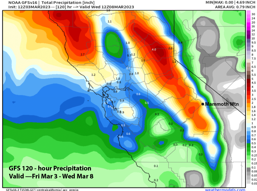
Overall amounts won’t be as large as the previous storms, but 2 feet is certainly possible at Main as the ECM model is forecasting more than 2” liquid (image below) that could result with up to 3 feet of snowfall up top. The GFS is not quite as wet (image below), but certainly has enough for deep powder conditions by Monday. Epic conditions continue, what a season.
Long Range (Days 5+)
The longer-range guidance has now come into better agreement after the GFS model was teasing us about a potential warm storm pattern. It now appears that the ECM model may have been on the right track with dry weather for the end of next week with that chance for a warm storm more likely to happen toward mid-month.
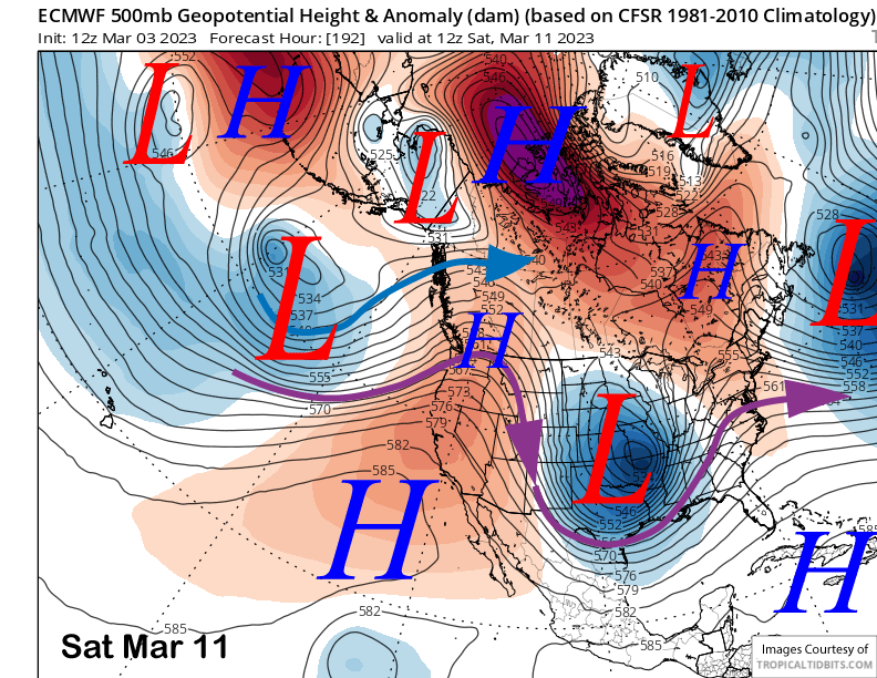
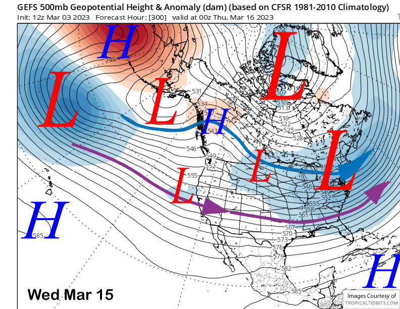
The ECM model builds a high pressure ridge into the state over the second weekend of March (image below) and pushes the storm track northward into British Columbia. It holds the ridge into the following week for continued dry weather. The Canadian moves a trough into NorCal on Sunday while the latest GFS has an inside slider type storm. Except for the Canadian that would produce light snowfall, model consensus is mostly dry weather for a while starting on next Thursday.
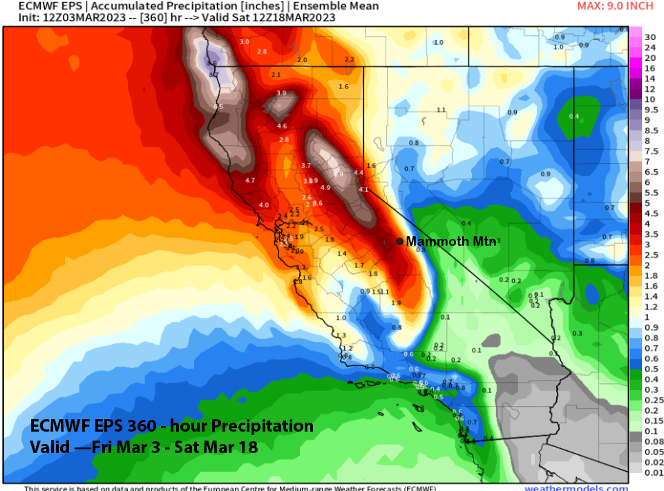
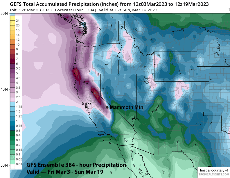
The next chance for snowfall will be around mid-month when the guidance is suggesting there could be a breakthrough of a westerly jet stream under an extension of the east Asian jet stream. Those are warmer type storms that produce Sierra cement. The ECM EPS (image below) is a bit more bullish than the GFS ensemble (two images below), but both models right now favor only a weak breakthrough and not a major event.
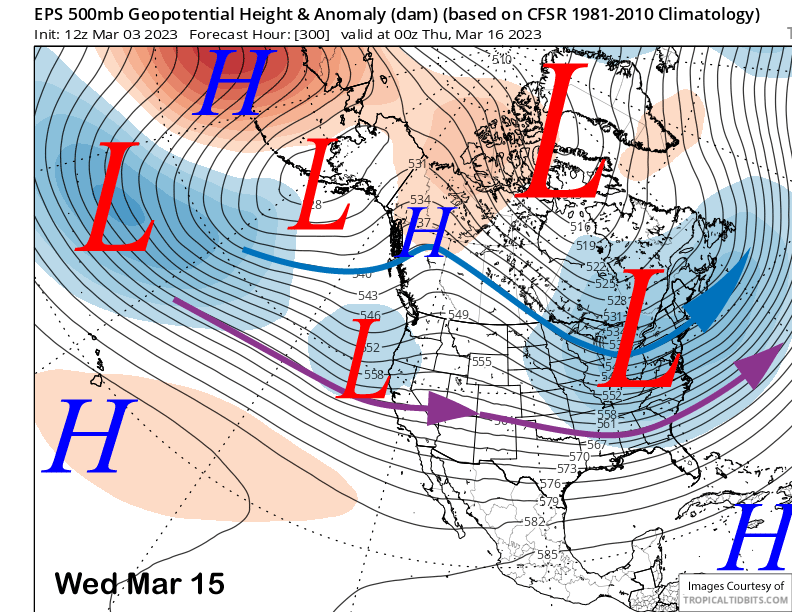
That is reflected in the QPF from the models with the EPS (image below) and GFS ensemble (two images below) both showing about 4” or so for the entire forecast period. As a reference point, the EPS was showing around 12” liquid for the January storm cycle back at the end of December. Thus, big event is not favored and with any snowfall likely being Sierra cement.
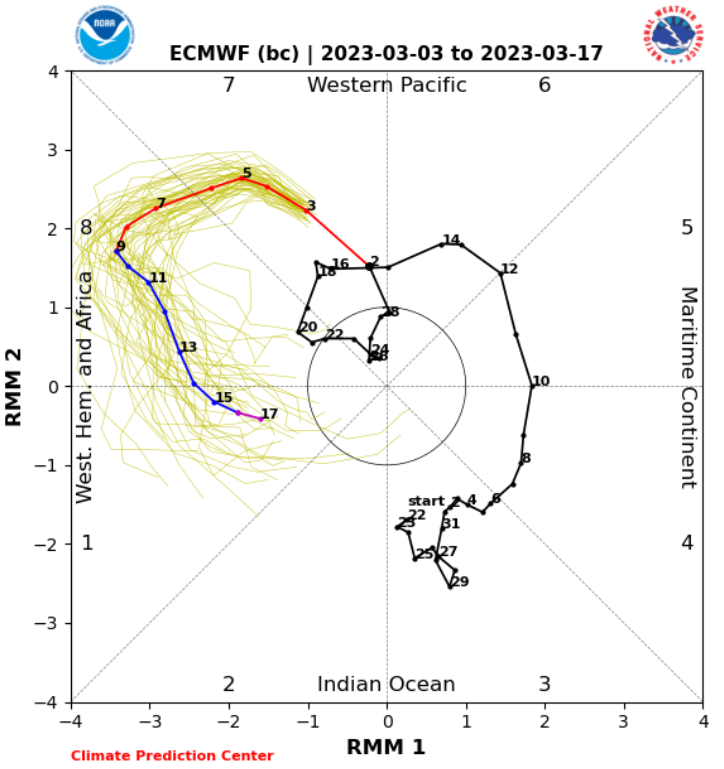
After that chance, it may go dry again for a while with maybe some weaker storm chances over the last week of the month, says the climate models. However, if the MJO stays active and moves into phase 1 during the 3rd week of the month, then storm chances may increase again. The latest forecast has such a scenario (image below). WG