Powder Forecast – Tuesday March 7th, 2023
Ted Schlaepfer CCM —- Mammoth Mountain WeatherGuy
Snowfall forecasts are valid at the Sesame snow course (Main Lodge) for the prior 24 hours as reported in the 6-7 AM morning snow report.
**Snowfall forecast confidence ranges from very low (1) to very high (5)
Wed 3/8 = 0”
Thu 3/9 = 1 – 2”
Fri 3/10 = 20 – 26” (H20 = 2.50” – 3.00”)**3
Sat 3/11 = 23 – 30” (H20 = 3.50” – 4.00”)**3
Sun 3/12 = 8 – 10” (H20 = 1.00” – 1.20”)**2
Mon 3/13 = 1 – 2”
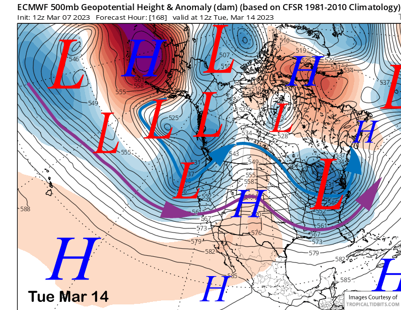
Tue 3/14 = 16 – 22”
Wed – Fri 3/15 – 3/19 = 9 – 15”
March Snowfall = 57”
March Forecast = 140 – 190”
Detailed 4-day Snowfall Forecast
Wed 3/8 – Light snowfall develops during the morning and ends during the afternoon. Accumulation around 1 – 2”
Thu 3/9 – Dry during the morning, the snowfall starts around midday/early PM and increases in intensity overnight becoming heavy after midnight. Accumulations 20 – 26” by Friday AM, 32”+ up top
Fri 3/10 – Heavy snow during the morning along with strong winds continues into the afternoon. Snow, heavy at times, continues at night. Snow levels peak during the afternoon at around ~8000 feet Accumulations 23 – 30” by Saturday AM, 36” up top
Sat 3/11 – Snow, mostly moderate, continues during the day and overnight. Accumulations 8 – 10” by Sunday AM
Forecast Summary:
Short Term (Days 1 – 4):
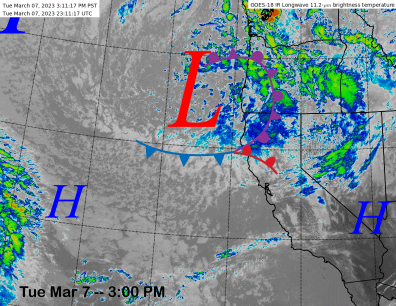
The current infrared satellite image (below) this afternoon shows a storm system and associated fronts situated off the NorCal and Oregon coastlines. That system will move southward overnight, and the tail end will clip Mammoth during the day Wednesday. Light snow starts in the morning and ends during the afternoon with around an inch or two accumulations.
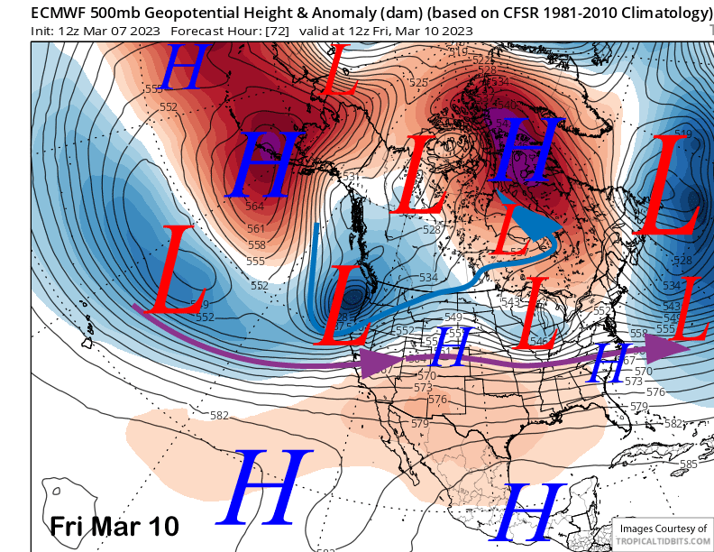
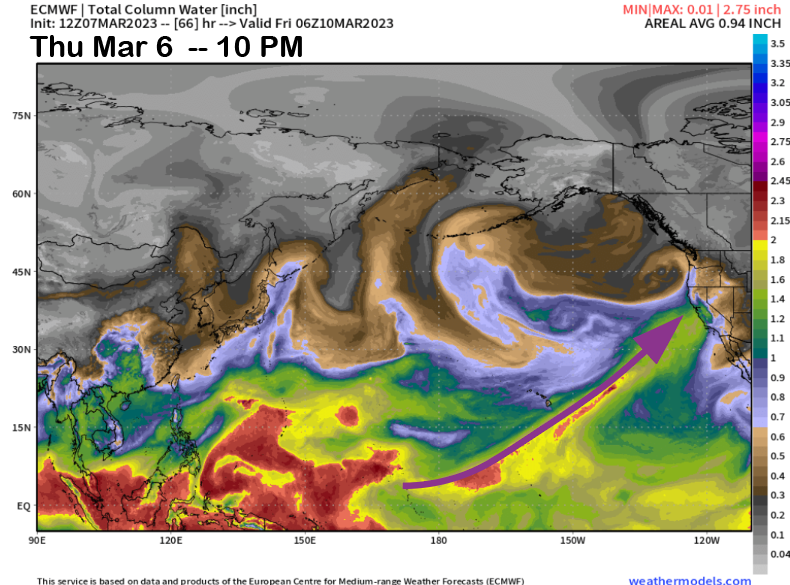
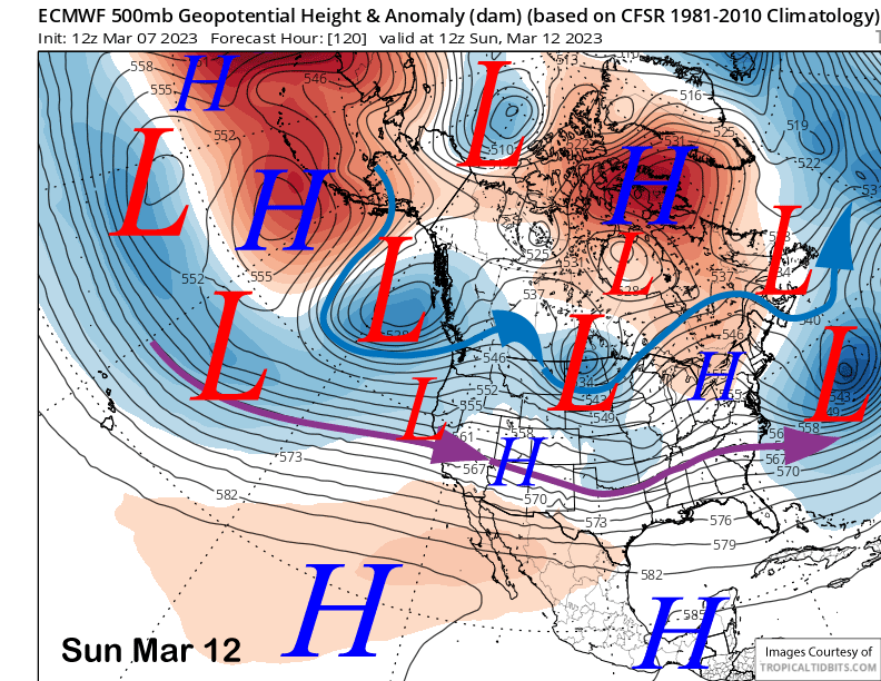
Attention then turns to the next storm that now appears to be a whopper. The ECM model (image below) and others now favor a breakthrough of the westerlies starting on Thursday (purple arrow in image). That will push a strong storm into CA from off the central Pacific as opposed to the Gulf of Alaska like the recent storms of late that produced the cold, dry, powder.
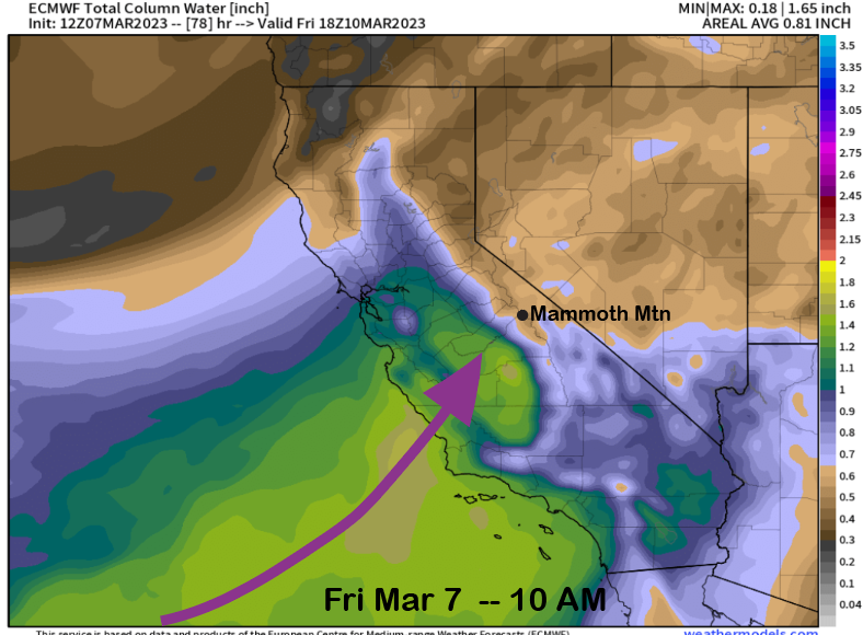
This storm will be tapping moisture that runs deep into the tropics with the precipitable water plume having origins all the way southward into the inter-Tropical Convergence Zone (image below). That plume will move into Central CA on Friday morning (two images below) and will be tapping almost 2” of vertically integrated atmospheric liquid.
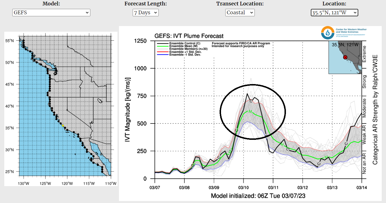
And that plume will have strong enough low and mid-level wind associated with it to qualify as an moderate strength Atmospheric River (AR) (image below). All that adds up to a warmer-type storm that will deliver a lot of Sierra cement type snow to the mountain and town.
As with most ARs, snow levels are always a concern as the warmest/strongest ones can often raise snow levels to as high as 10K. Thanks to the antecedent cold weather now in place, this time it looks like snow levels will mostly stay at 8K or lower for the event due to evaporative cooling. Snow levels looks to peak Friday afternoon and early evening before lowering slightly overnight into Saturday. Snow levels Saturday should be around 7000 feet, rising slightly during the afternoon, and then sinking back to 7K Saturday night.
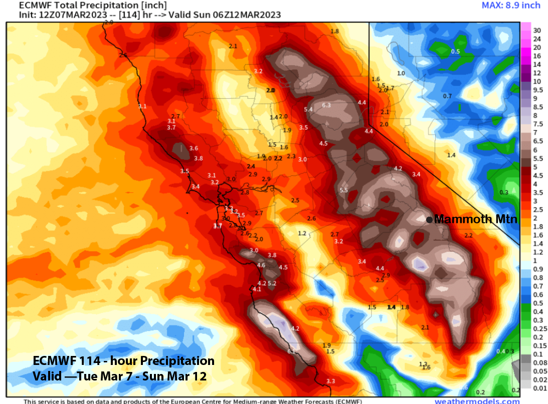
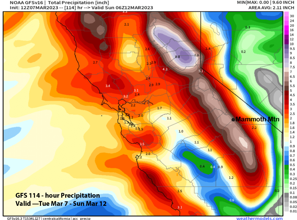
Liquid amounts with the storm are looking juicy with both the ECM (image below) and GFS (two images below) showing amounts larger than 6 inches with the ECM slightly wetter. Snow ratios will probably be in the 8-9”:1” range to start before decreasing to 6-8”: 1” by Friday, and then may increase slightly Saturday into Sunday, but should not get higher than 9-10”:1”.
Snowfall will be the heaviest on Friday morning/early PM, but will also be heavy by Thursday evening and overnight and also at times on Friday evening and night. Winds will get strong by Thursday afternoon and night with the strongest winds on Friday, especially the morning. Winds on Saturday and Sunday don’t look too bad with Ch 22 possibly having a chance to run. I would not be surprised if most of the mountain is shut down on Friday due to the storm.
Snowfall should continue into Sunday afternoon before ending Sunday night as the ECM model moves another weak wave into the state Sunday AM (image below). That break will be short-lived though.
Long Range (Days 5+)
The longer-range guidance has now come into agreement and it is saying “Game On”. This season is exemplifying the term “Feast or Famine” to the extreme as we our already full of snow and we keep getting more in this amazing Feast season.
The out of towners are probably exited to hear below about a parade of storms poised to move into Mammoth resulting in possibly the deepest snowpack Mammoth has ever seen by the time it is said and done, and that may result in skiing for most of the summer. The locals on the other hand, are probably not too happy to hear about more endless shoveling and mounds of snow with nowhere to put it. This could turn into a town disaster.
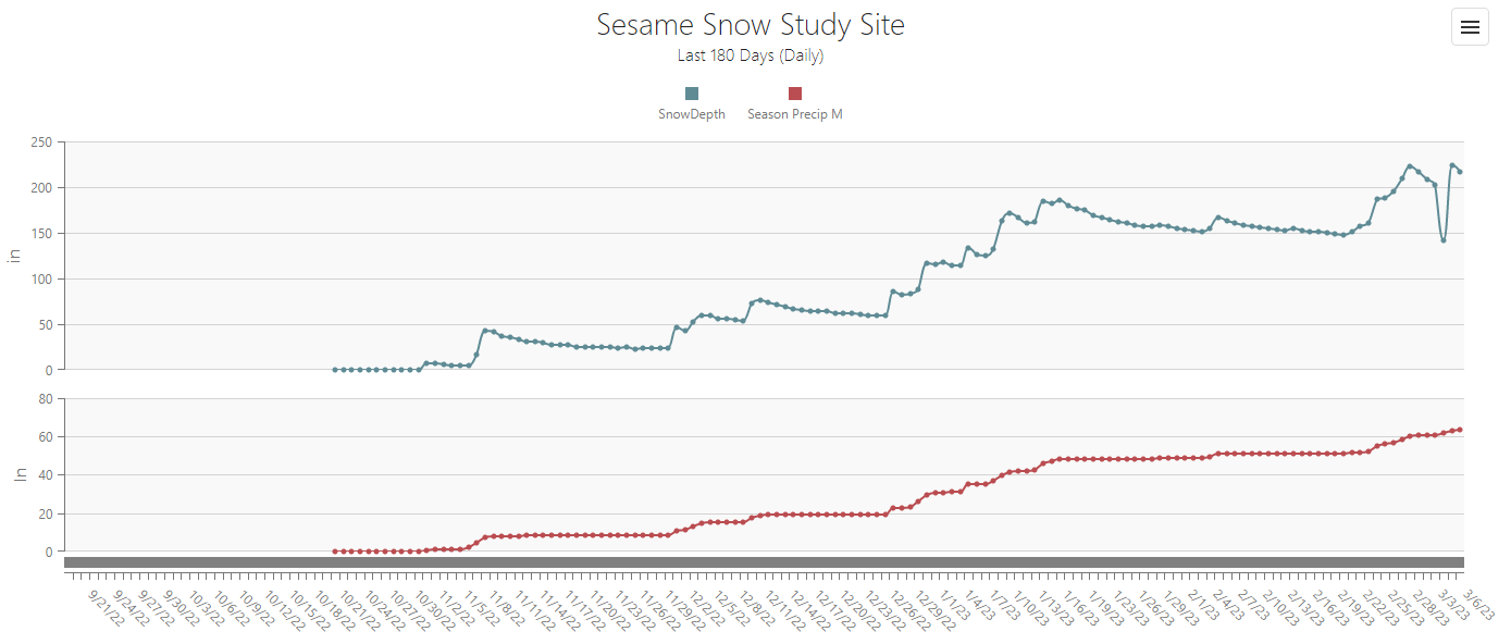
Now back to the good insight about the upcoming pattern. The sesame snow sensor only have a maximum depth of 250” (image below). Soon will we not know the exact depth of the base at Main as we will blow past that number. I have only seen it reach the old depth of 230” once during the great 2010-11 season. This year feels like a combo of that season and 2016-17.
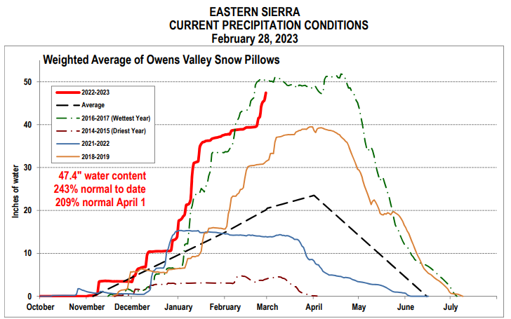
This hasn’t updated in a week and doesn’t include the recent snowfall, but regardless, we will set a new SWE season record this year (image below) and should move past 2016-17 easily. I am thinking it will be in the 60” range or higher by the end of the month.
The ECM model and others move the next upper trough into the state by early Tuesday (image below). That will push another warmer-type storm into Mammoth with snowfall starting as early as Monday night. This one probably won’t have an AR, amounts still look to be 2” liquid or slightly higher.
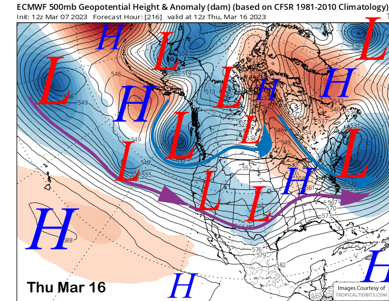
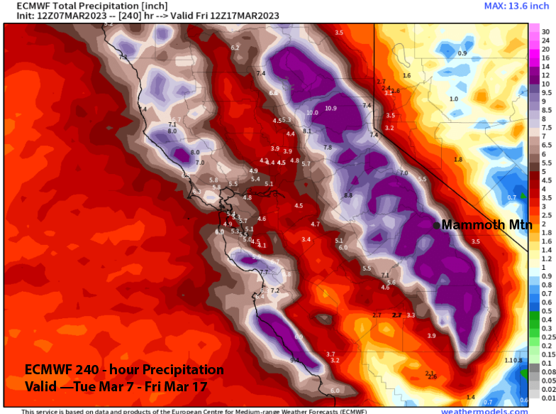
That may be followed by another one toward the end of the week (image below) and into the following weekend for more heavy snowfall. The westerly jet stream looks to stretch across most of the Pacific, similar to the January pattern. Snow levels with these storms look to be 7K or lower. ECM total liquid precipitation for the 10-day pattern is over 10” (two images below).
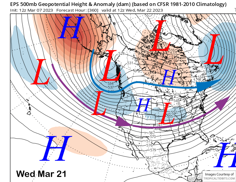
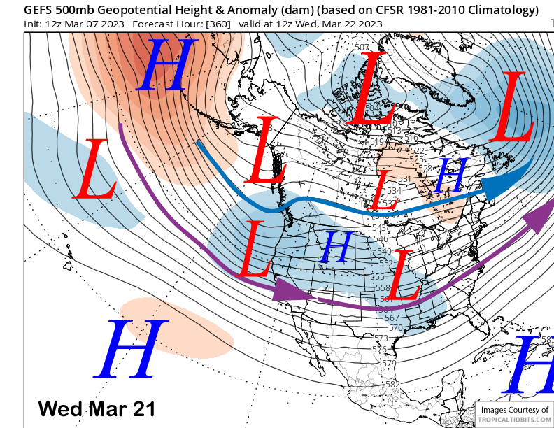
The longer range ensemble forecasts keep the westerly jet aimed into CA in the fantasy time frame. The ECM EPS (image below) is a bit stronger than the GFS ensemble (two images below), but both support moderate to strong storms moving into CA off the Pacific with possible embedded ARs.
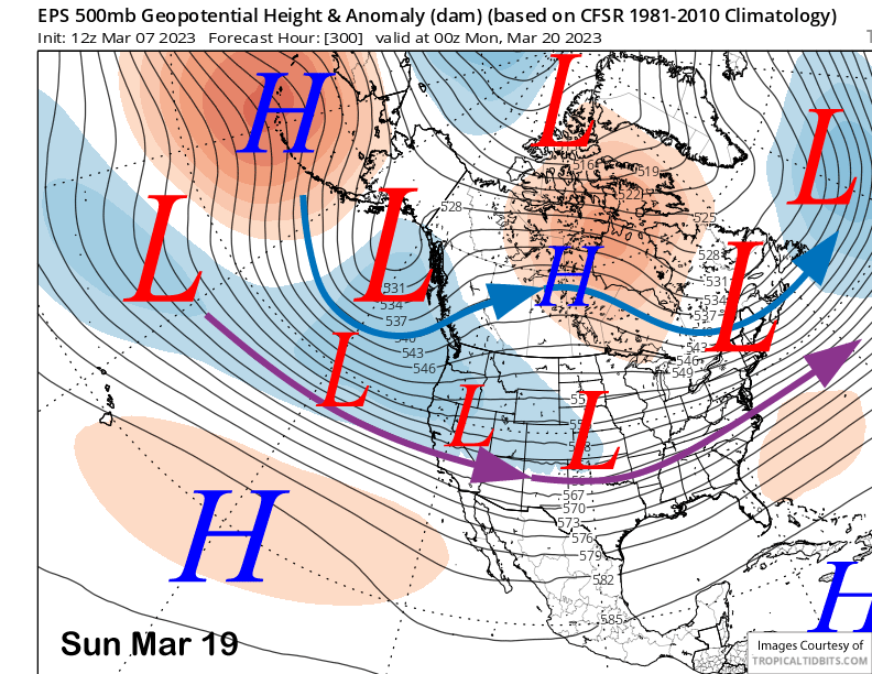
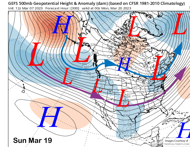
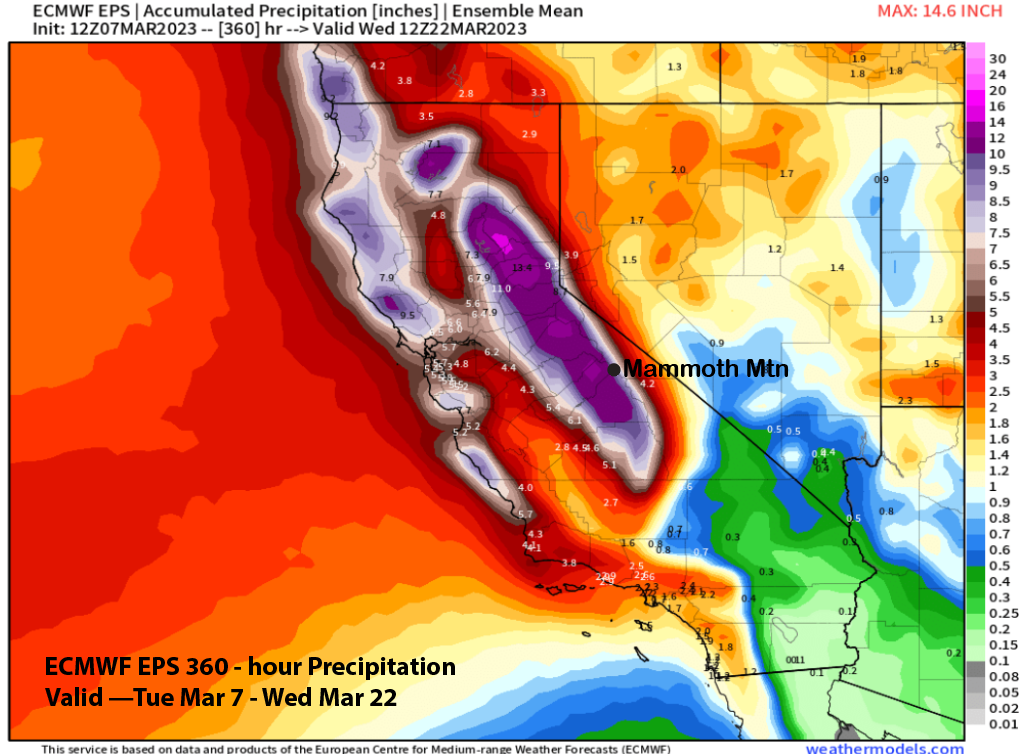
And the pattern looks to remain locked through the 3rd week of the month or longer. Again, the ECM EPS (image below) is a bit stronger versus the GFS ensemble (two images below). Both patterns support moderate to strong storms with possibly embedded ARs.
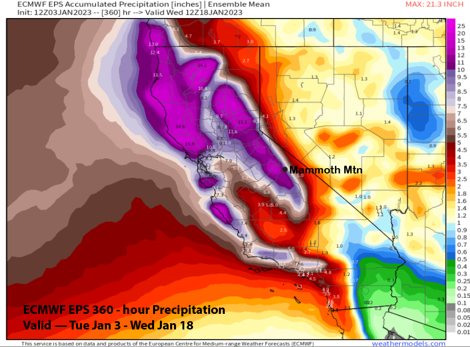
The ECM EPS total precipitation for the period (image below) is over 12” liquid. That is similar to what the model was predicting in early January for that event (two images below). Overall, a lot of snowfall is expected for the next two weeks or longer. I’ll just leave it at that. WG