Powder Forecast – Friday March 10th, 2023
Ted Schlaepfer CCM —- Mammoth Mountain WeatherGuy
Snowfall forecasts are valid at the Sesame snow course (Main Lodge) for the prior 24 hours as reported in the 6-7 AM morning snow report.
**Snowfall forecast confidence ranges from very low (1) to very high (5)
Sat 3/11 = 18 – 24” (H20 = 3.00” – 3.50”)**3
Sun 3/12 = 7 – 9” (H20 = 1.00” – 1.20”)**3
Mon 3/13 = 5 – 7” (H20 = 0.60” – 0.85”)**2
Tue 3/14 = 1– 3”
Wed 3/15 = 20 – 30”
Thu 3/16 = 1– 2”
Fri 3/17 = 0”
Sat – Mon 3/18 – 3/20 = 10 – 20”
March Snowfall = 70”
March Forecast = 140 – 180”
Detailed 4-day Snowfall Forecast
Sat 3/11 – Snow, mostly moderate, but occasionally heavy, continues during the day and overnight. Accumulations 7 – 9” by Sunday AM, around 12” up top
Sun 3/12 – Snow, sometimes heavy, continues during the day before tapering off overnight. Accumulations 5 – 7” by Monday AM, around 10” up top
Mon 3/13 – Mostly dry during the day, then snowfall re-develops overnight. Accumulations 1 –3” by Tuesday AM
Tue 3/14 – Heavy snow and strong winds during the day with snowfall decreasing overnight. Accumulations 20 – 30” by Wednesday AM
Forecast Summary:
Short Term (Days 1 – 4):
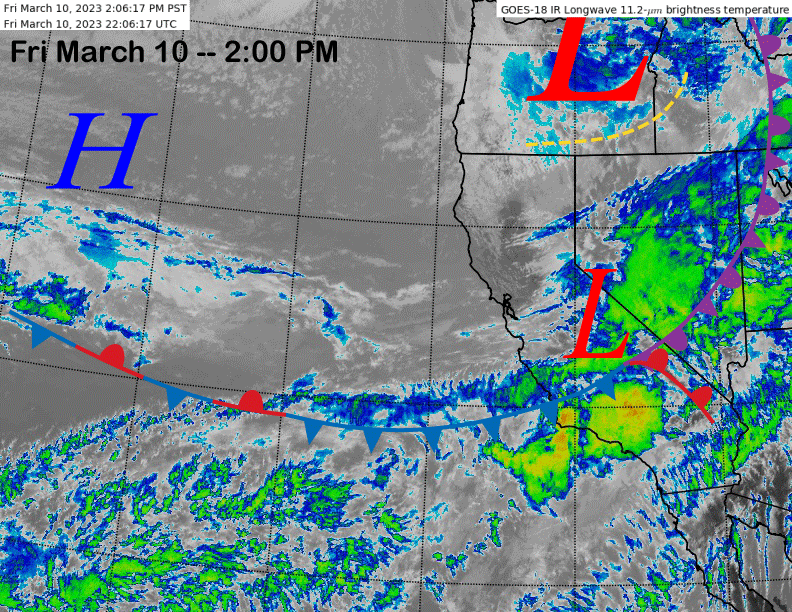
The current infrared satellite image (below) this afternoon shows a storm system and associated atmospheric river moving into the Central and Southern Sierra. Heavy snowfall is ongoing with snow levels sitting at about 8000 feet or so. Snow levels may rise a bit through this afternoon to near Canyon Lodge before falling tonight back down to 6000 feet tonight.
Snowfall rates are expected to decrease this evening, but moderate snowfall should continue overnight and during the day tomorrow, occasionally heavy. That forecast is similar for Sunday as the models move another short-wave onto the coast Sunday morning (image below) with snowfall expected to taper off Sunday night. Winds tomorrow and especially Sunday won’t be as strong as today.
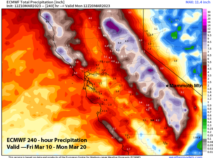
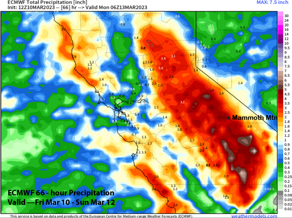
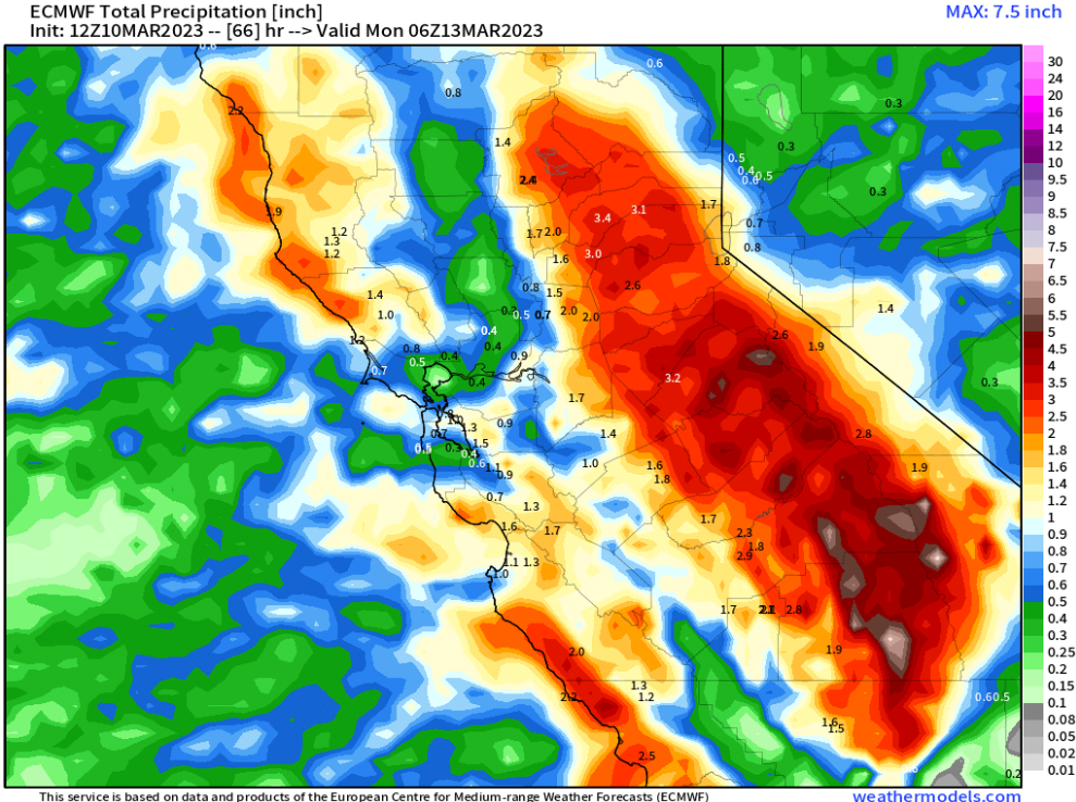
ECM model is showing almost 4” liquid through Sunday (image below) and that might be a bit low given the long duration event and a good moisture source under the westerly jet stream flow. Snow ratios are currently running in the 5-6”:1” range and should remain in the 6-8”:1” through the weekend. Two to three more feet of snow should fall at Main and around 4 feet up top.
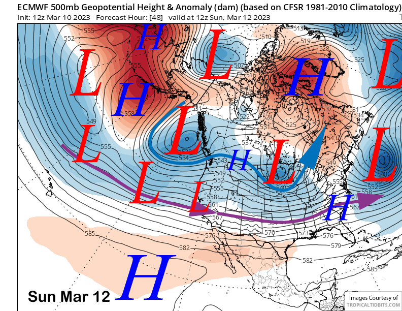
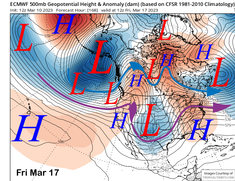
There may be a brief break on Monday before the next storm system arrives on Tuesday (image below) when the models show another potent short-wave moving into the state. It will be another storm from the central Pacific and warmer-type storm.
Models are also forecasting it to contain another Atmospheric River (AR), but not quite as strong as the current event as it is expected to be weak/moderate strength (image below). Nonetheless, heavy snowfall and strong winds are expected to develop again early Tuesday and continue during the day and into Tuesday night.
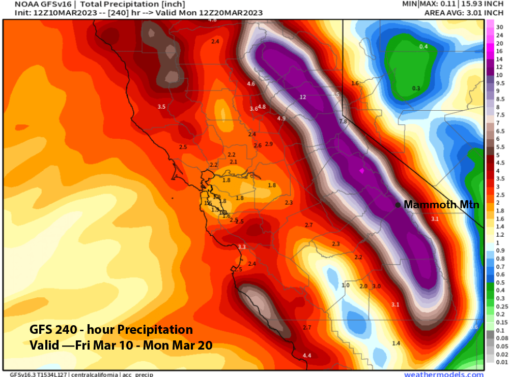
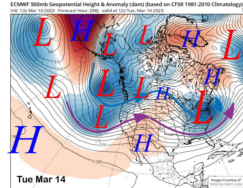
The ECM model is forecasting around 3”+ liquid with the storm (image below) while the GFS is wetter with over 4” liquid. Snow levels will be slightly higher versus the current event and will probably be just under 8K at peak Tuesday afternoon before lowering overnight as the snowfall is decreasing.
Snow ratios will probably be in the 5-6”:1” range for the peak part of the storm resulting in about two feet of Sierra cement at Main and more up top. Winds will also be strong on Tuesday when the AR rolls through and I would not be surprised if most, if not all, of the resort is closed again.
Long Range (Days 5+)
The longer-range guidance is still favoring the storm cycle to mostly continue through the extended 15-day time range with some differences between the models about strength and timing. One thing that may be different is the storms may get colder heading into the last week of March, we’ll see.
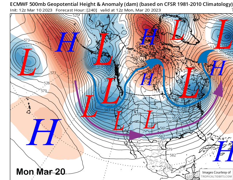
The guidance is in general agreement that there will be a brief dry period starting around Thursday next week and continuing Friday when a short-wave ridge builds into the state (image below). That ridge and dry weather may last into Saturday or even Sunday, confidence is low.
There is a Japanese term call Modoki that used to describe an El Nino in the central equatorial Pacific that is off-center from its usual position farther east. Its translation means “similar, but different”. That term adequately fits the description between the differences in the guidance in the longer term around 10 days out.
All the models are showing distinct differences in their respective solutions for the 240 hour forecast (images below), but all the outputs would result in more snowfall for Mammoth.
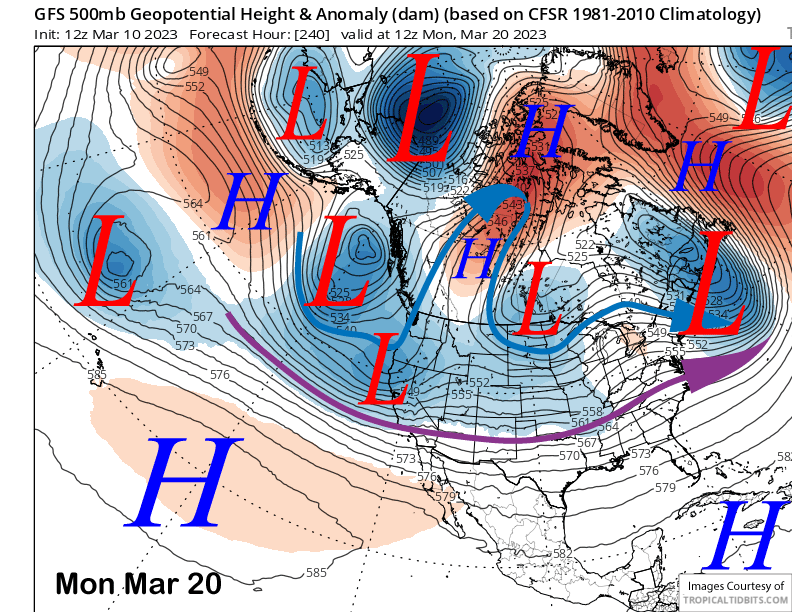
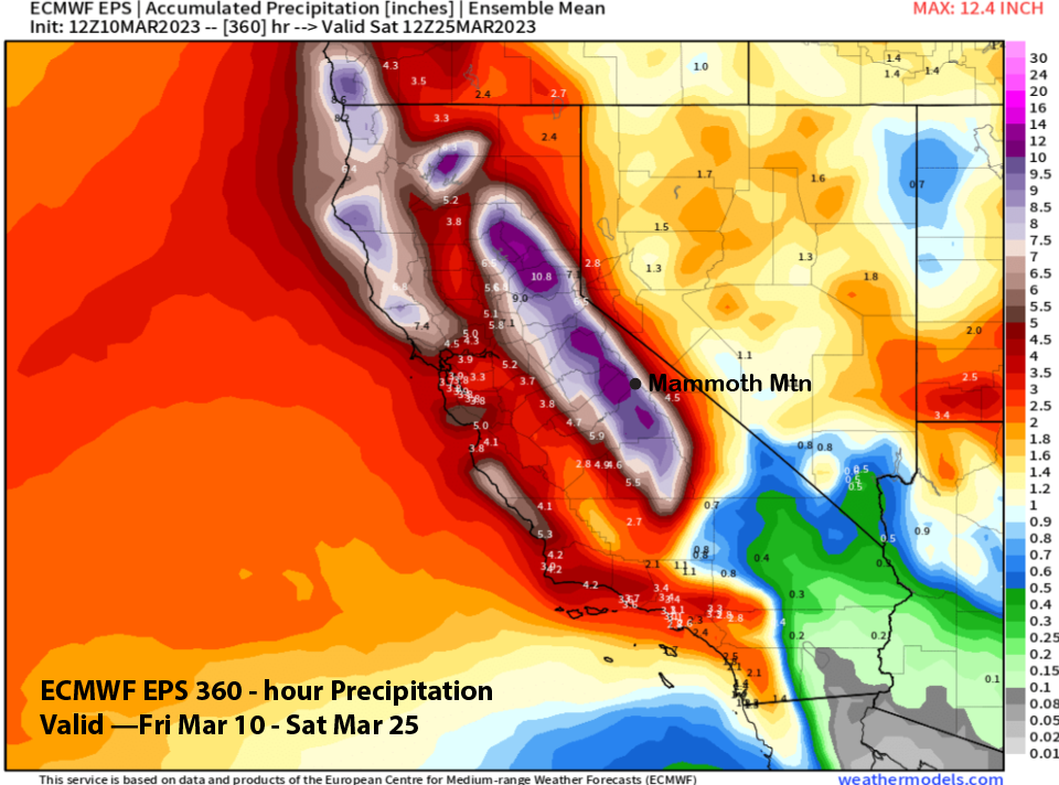
The ECM EPS (image below) generally supports a more zonal flow pattern, but maybe not as intense as the Canadian solution. Timing suggests the best chance for more snowfall will be over the latter part of the weekend and into early the following week.
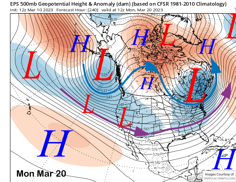
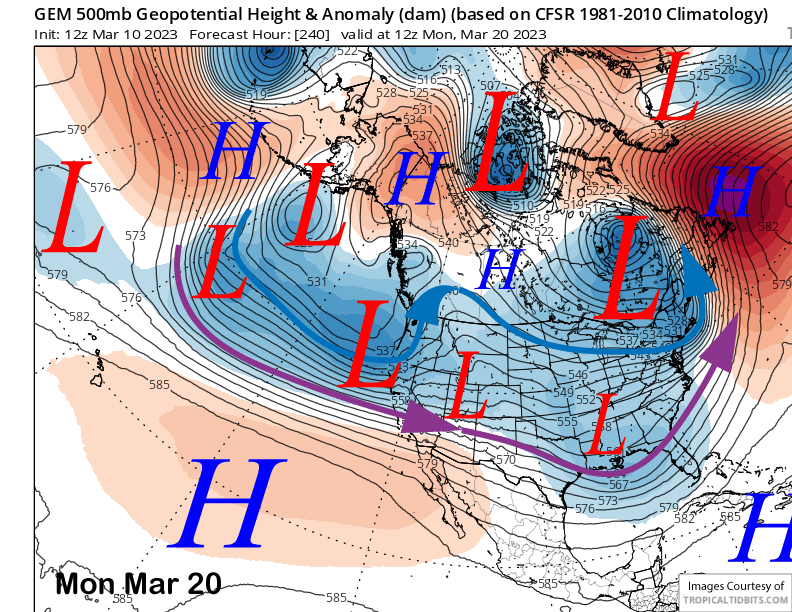
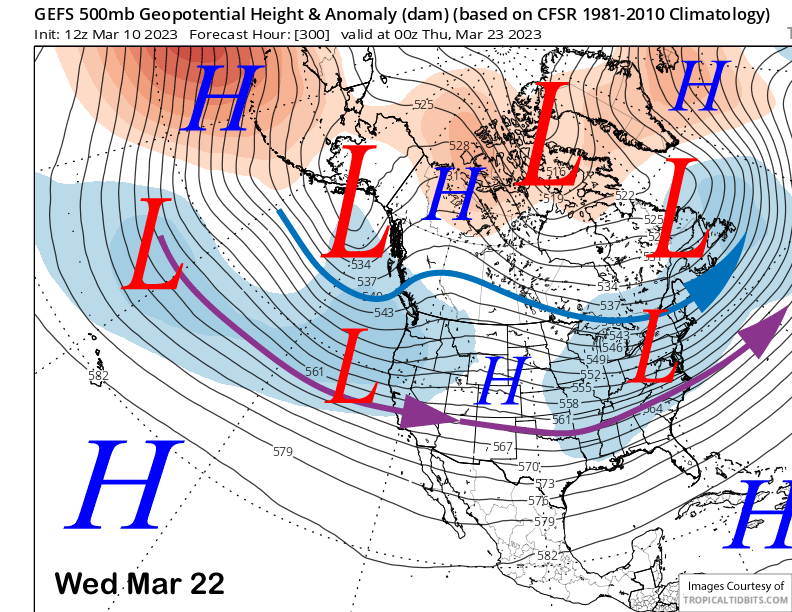
The GFS ensemble (image below) and ECM EPS (two images below) both keep a trough and mostly westerly jet stream pointing into CA in the fantasy period. The ECM EPS is slightly deeper with the longwave trough with both models showing a robust jet stream that could support a stronger storm.
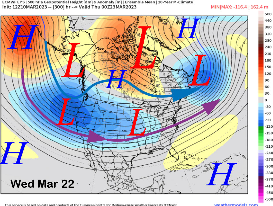
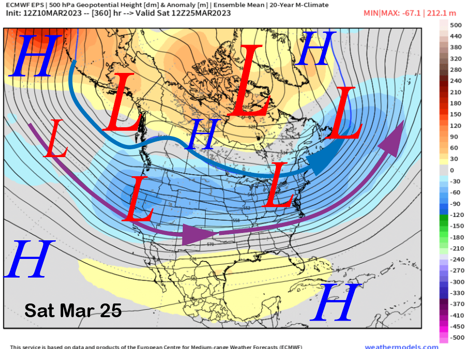
The ECM EPS (image below) mostly keeps this pattern in place into the following weekend with only a slight shift eastward with the long-wave trough and a bit more northwest jet stream flow. That means potential storms may start to trend colder as the storms move into the state from the Gulf of Alaska again as opposed to the central Pacific. Low confidence.
Overall, the ECM (image below) and GFS (two images below) are forecasting between 7-10” liquid over the next 10 days and the ECM EPS (three images below) is showing about 10” for the 15-day period. A lot more snowfall will occur before there is any signs of a sustained dry period that might occur toward the end of the month. About 100” before we break the total snowfall record from 2010-11, it could happen. WG