March 12th, 2023 @ 11:20 AM Good Sunday morning, the March winter storm continues in the higher elevations with snowfall at this time.
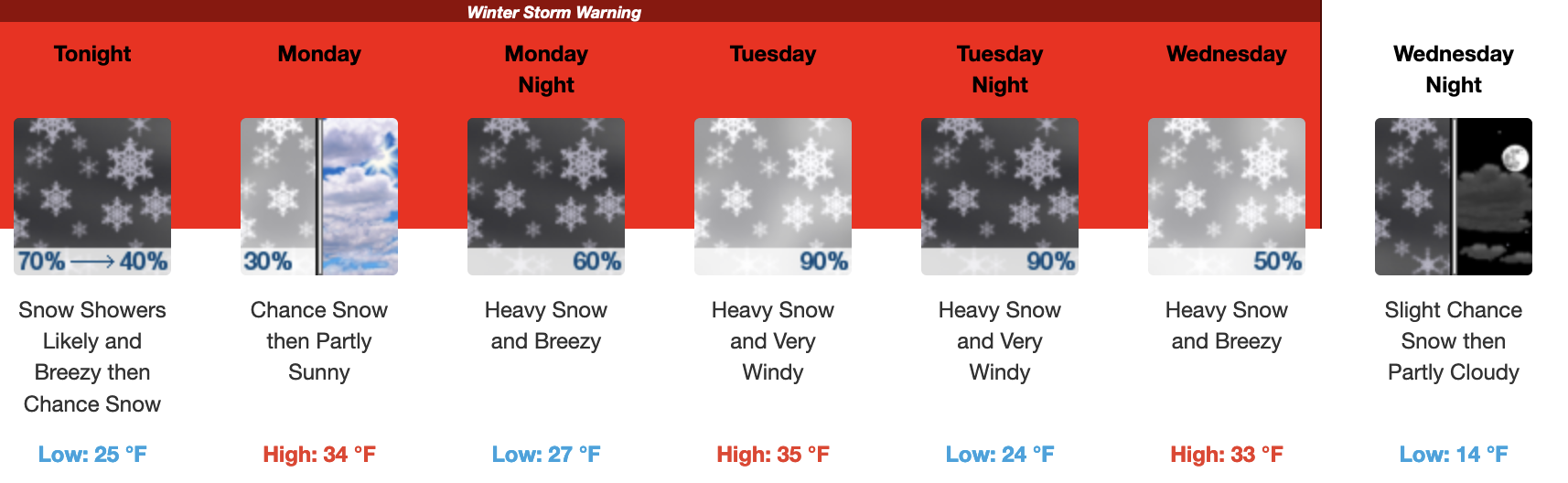
Current Weather Alerts: WINTER STORM WARNING UNTIL WEDNESDAY MORNING FOR AREAS ABOVE 7000 Feet…BEWARE OF EXTREME AVALANCHE DANGER.
Discussion for Wednesday morning: Time to review what’s happened with storm number and then take a look at storm two and the upcoming week ahead.
Storm #1 recap – Looking at the data from the Snow Study Site at 9000 feet there has been an estimated 8 inches of water content over the last 3 days with 3-4 feet of new snow. If those numbers are correct the snow that fell was down at 3-1 to 4-1 in snow ratio during most of action, that is what you call some very heavy wet base snow.
The good news from storm number one and it’s pineapple connection is that rain line did stay below the ski area from what I saw and have heard from others in town.
The remains of the first system will be in the area over the next 24 hours with models showing around an in the QPF forecast with 5-10 inches of snow possible by Monday morning.
Weather System #2 will be moving in Monday night with the full brunt of moisture set to hit early Tuesday and lasting throughout the day. The snowfall should continue into early Wednesday and then quickly turn to snow showers and then clearing out by next Thursday.
This next system will have lower snow levels with snow ratios expected in the 8:1 and then 10-1 with 12-1 at the very end. Those higher ratios will help seal in and cover the base snow from this weekend. Snowfall totals from 9000 feet to the top look to range in the 2-4 foot range with 1-2 feet possible in Mammoth Lakes.
For those heading up to ski and ride, there should be some decent freshies and mid winter packed powder by Wednesday and Thursday.
For next weekend more snow is in the forecast with light to moderate amounts as there will be no big AR hook up at this time.
If you’re going to be out on Mammoth Mountain Monday expect snow showers with 1-3 inches of new snow possible. Temperatures will be in the low to mid 30s with SW winds 15-25 with gusts in the 35-55 MPH range over the higher elevations.
On Tuesday expect heavy snow and strong winds with very limited lift access. Snow Showers will be numerous on Wednesday and then the AR flow will cut off.
By Thursday there will be a full break in the snowfall with snow showers returning Friday through the weekend.
Ski Ya Later Snowman