Powder Forecast – Friday, January 3rd, 2020
Ted Schlaepfer CCM —- Mammoth Mountain WeatherGuy
Snowfall forecasts are valid at the Sesame snow course (Main Lodge) for the prior 24 hours as reported in the 6-7 AM morning snow report.
**Snowfall forecast confidence ranges from very low (1) to very high (5)
Sat 1/4 = 0”
Sun 1/5 = 0”
Mon 1/6 = 0”
Tue 1/7 = 0”
Wed 1/8 = 1 – 2”
Thu 1/9 = 0”
Fri 1/10 = 0”
Sat – Mon 1/11– 1/13 = 6 – 15”
January Snowfall = 0”
January Forecast = 50 – 80″
Detailed 4-day Snowfall Forecast:
Saturday 1/4 through Tuesday 1/7 —No snowfall expected all days except for a chance for light snowfall overnight Tuesday and into next Wednesday.
Forecast Summary:
Short Term (Days 1 – 4)
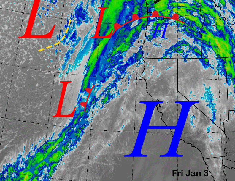
Satellite imagery this afternoon (below) shows high pressure is over CA today with a splitting weather system well off the coast. That system will move ashore tomorrow with some light rain for NorCal and clouds and breezy/gusty winds for Mammoth. No snowfall is expected with possibly some wind buff up top from the winds.
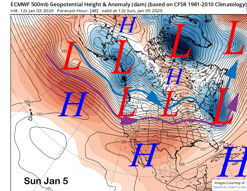
A trailing upper-level low-pressure system will move into NorCal on Sunday (image below) and again no snowfall is expected in Mammoth. Winds will likely increase again for possibly more wind buff up top during operations along with colder temperatures.
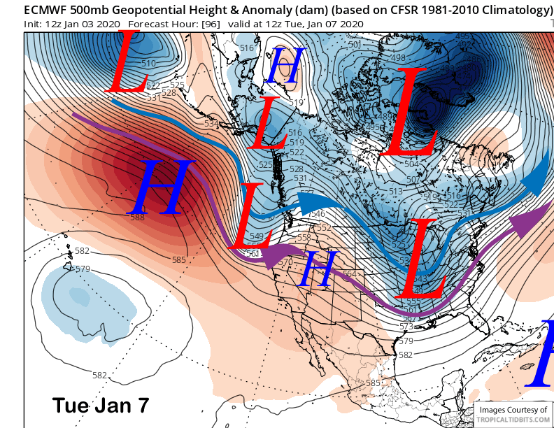
High pressure will then rebuild over CA until mid-week when the next relatively weak upper-level trough moves into CA (image below). That one may move a bit farther southward for a chance for light snowfall overnight Tuesday and into Tuesday. It does not look like enough will fall for powder conditions.
Long Range (Days 5+):
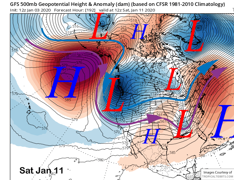
The longer-range guidance is suggesting that discontinuous retrogression of the ridge in the eastern Pacific will occur in the 8-15 day pattern. The mean position will move from the Gulf of Alaska westward into the Aleutians while also strengthening. That will eventually produce a deep longwave trough along the West Coast.
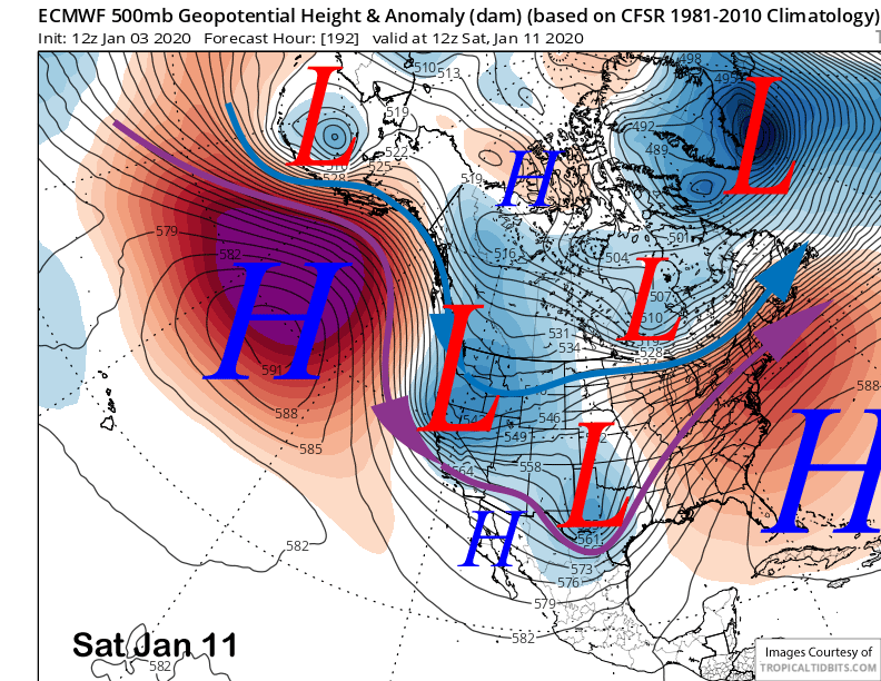
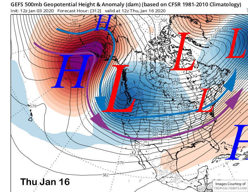
The ECM model is slower than the GFS with this transition. It moves a cold upper-level trough (image below) southward end of next week and over the following weekend that does not have a lot of over-water trajectory and thus limited moisture entrainment. Nonetheless, it is deep enough to squeeze out over 0.50” liquid and a solid six inches of snowfall.
The GFS retrogrades the ridge westward faster and has a more over-water trajectory in addition to a deeper upper-level trough (image below) for the same time period. The Canadian is closer to the ECM model or even slightly farther eastward with the passage of the trough.
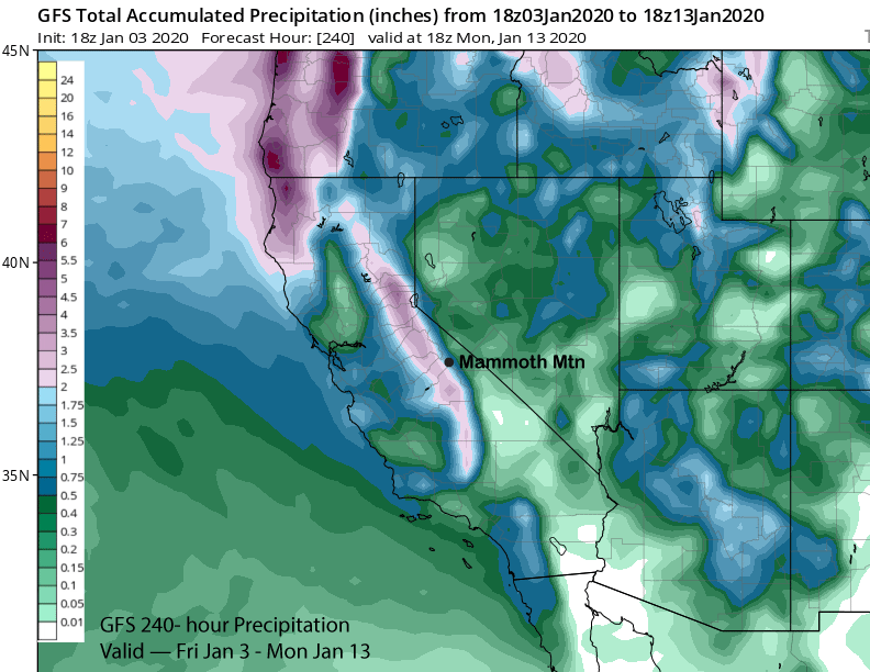
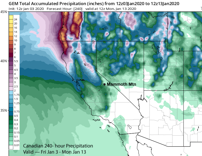
Thus, model QPS varies quite a bit with the GFS showing almost two inches liquid (image below) while the Canadian doesn’t even have a half an inch (two images below). With a cold storm, that is a difference of almost two feet versus a few inches of snowfall.
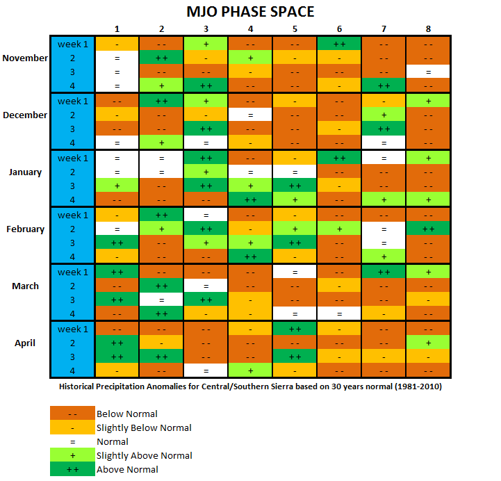
The key to the eventual evolution of the pattern may lie with the MJO signal out of the tropics. After lying dormant so far this winter, it is forecast to emerge strongly into phases 4 and 5 over the second and third weeks of January (image below).
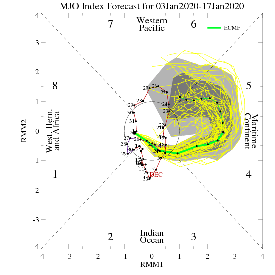
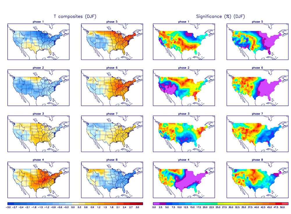
Historical MJO precipitation analogs for the central and southern Sierra (image below) favor average precipitation in phases 4 and 5 second week of January before transitioning to above normal third week of January in phase 5. It also favors cold temperatures across the West in phase 5 during JFM.
Overall, the GFS may be too fast with the transition with the ECM model more lined up with the MJO analogs. CPC analogs also favor a slower transition and also just after mid-month. Thus, the GFES forecast of a deep trough (image below) third week of January may be legitimate.
This pattern is similar to the snowy pattern that occurred early last February 2019, although the staying power of the pattern is questionable as the longwave trough remained mostly stationary last February. That was an epic month of cold and dry powder except for one storm period mid-month when a warmer storm and AR occurred. So after a nice little dry spell to start the month, it looks like there is potential for good snowfall heading into and just after mid-month. WG


