Powder Forecast –Tuesday, November 2nd, 2021
Ted Schlaepfer CCM —- Mammoth Mountain WeatherGuy
Snowfall forecasts are valid at the Sesame snow course (Main Lodge) for the prior 24 hours as reported in the 6-7 AM morning snow report.
**Snowfall forecast confidence ranges from very low (1) to very high (5)
Wed 11/3 = 0”
Thu 11/4 =0”
Fri 11/5 = 0”
Sat 11/6 = 0”
Sun 11/7 = 0 – 1”
Mon 11/8 = 0 – 2”
Tue 11/9 = 3 – 12”
Wed – Fri 11/10 – 12 = 3 – 9”
November Snowfall = 0”
November Forecast = 20– 40”
Detailed 4-day Snowfall Forecast:
Wed 11/3 through Sat 11/6 – No snowfall expected all days.
Forecast Summary:
Short Term (Days 1 – 4):
The current infrared satellite image (below) shows a high-pressure ridge building into California today after the passage of a weather system to the North yesterday. That ridge will hold through tomorrow before edging eastward tomorrow night and Thursday.

The next weather system (image below) will move into NorCal tomorrow night and Thursday and all of the precipitation is now expected to stay north of Mammoth.
Temps may cool slightly Thursday into Saturday, but snowmaking conditions will continue to be poor for the rest of the week and into the weekend under continued dry weather.

Long Range (Days 5+):
The longer-range guidance is looking pretty good for an impactful storm early next week and appears to be the only real chance in the 15 day forecast period or longer as the second half of November may be mostly dry.
The ECM model first moves a weak, moisture-starved storm into NorCal by early Sunday (image below), and again, keeps the precipitation well north of Mammoth.
The GFS does move some light snow showers into Mammoth early Sunday and the Canadian is more bullish about moderate snowfall Sunday, so uncertainty with the forecast starts over the latter part of the weekend.

Longer range ensembles are still favoring a stronger trough to move into California around Tuesday next week (GFS ensemble below). The operational models are still all over the place trying to figure out the details of the upcoming pattern. The latest ECM model (two images below) is strong, but farther north with the trough and moves most of the precipitation north of Mammoth.


The GFS is farther southward (image below) and shows almost two inches of liquid while the GFS ensemble has over 2” for the crest (two images below).
Best of all, the Canadian is showing a much stronger solution and has about 6” liquid of the Sierra crest west of Mammoth.


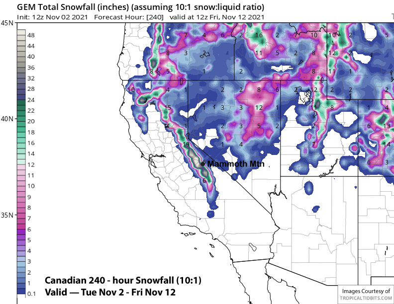 It is still too far out to know if the stronger solution will verify with the best forecast right now a blend of the GFS ensemble and ECM ensemble that has almost 1.5” liquid.
That would translate to at least a foot of snow at Main and likely more up top. The models will likely have a good handle on the potential system by the Friday update.
After this potential storm, the GFS ensemble mean is rather bullish about building a fairly strong high-pressure ridge over CA by the end of the week and through the following weekend (image below).
It holds it mostly in place for the rest of the 15-day forecast period or longer for fair and dry weather and probably not great snowmaking conditions. Hopefully, the dry pattern will break by the last week of the month. WG


