Powder Forecast – Friday March 17th, 2023
Ted Schlaepfer CCM —- Mammoth Mountain WeatherGuy
Snowfall forecasts are valid at the Sesame snow course (Main Lodge) for the prior 24 hours as reported in the 6-7 AM morning snow report.
**Snowfall forecast confidence ranges from very low (1) to very high (5)
Sat 3/18 = 0”
Sun 3/19 = 0”
Mon 3/20 = 6 – 8” (H20 = 0.70” – 0.90”)**3
Tue 3/21 = 5 – 7” (H20 = 0.50” – 0.70”)**3
Wed 3/22 = 12 – 15” (H20 = 1.00” – 1.25”)**2
Thu 3/23 = 1 – 3”
Fri 3/24 = 0”
Sat – Mon 3/25 – 3/27 = 3– 9”
March Snowfall = 120”
March Forecast = 150 – 170”
No Update on Tuesday
Detailed 4-day Snowfall Forecast
Sat 3/18 –No snowfall expected except for a chance for flurries Saturday evening
Sun 3/19 –Light to moderate snowfall develops during the morning hours and continues during the day and at night. Accumulations 6 – 8” by Monday AM, up to 10” up top
Mon 3/20 –Moderate snowfall during the morning decreases during the afternoon and ends by evening. Snowfall may then re-develop late at night. Accumulations 5 – 7” by Tuesday AM, ~6” up top
Tue 3/21 –Moderate to heavy snowfall develops during the day with light to moderate snowfall continuing overnight. Accumulations 12 – 15” by Wednesday AM, 15”+ up top
Forecast Summary:
Short Term (Days 1 – 4):
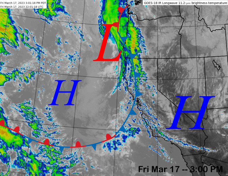
The current infrared satellite image (below) this afternoon shows a dissipating weather system about to move into central and northern CA. Only passing clouds are expected with the weather system tonight. Dry weather should continue through tomorrow with only a chance for a late afternoon or evening snow flurry.
The ECM model (image below) moves a weak short-wave into CA on Sunday and it should be strong enough to produce some light to moderate snowfall during the day and it should continue overnight as a trailing short-wave will move into the state on early Monday (image below).
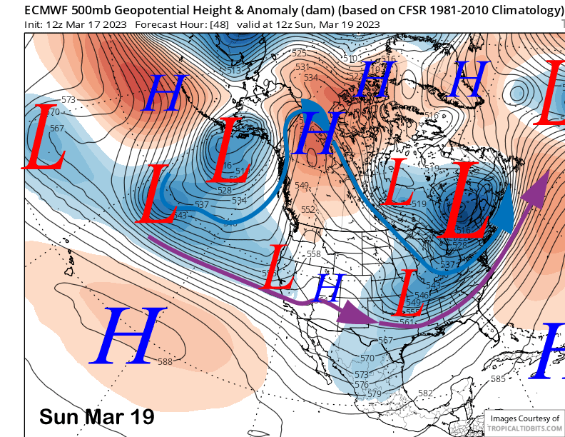
That will produce a period of moderate snowfall during the morning hours that will decrease and end during the afternoon or evening. Amounts between the two days could add up to a foot at Main with more than a foot likely up top. Snow levels will be about 7K on Sunday and around 5000 feet on Monday. The snow will not be as wet/heavy or cement like as the previous storms.
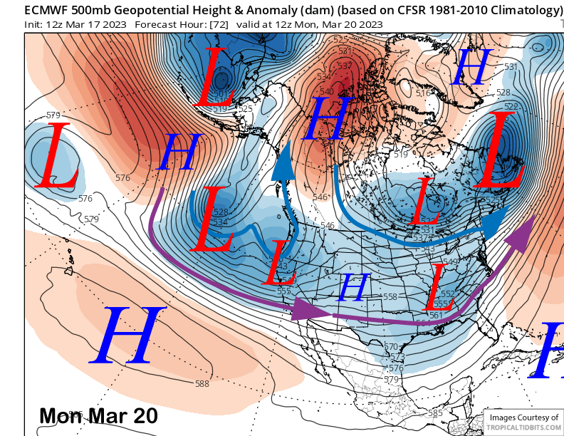
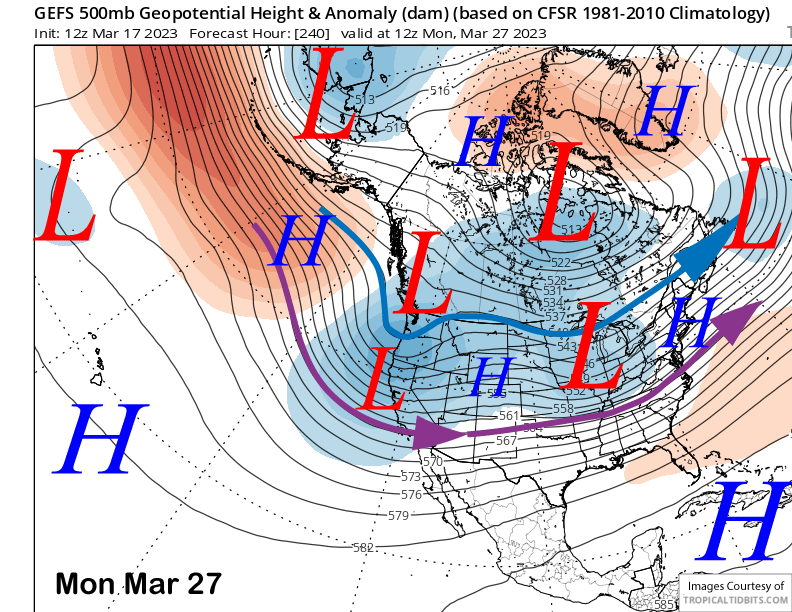
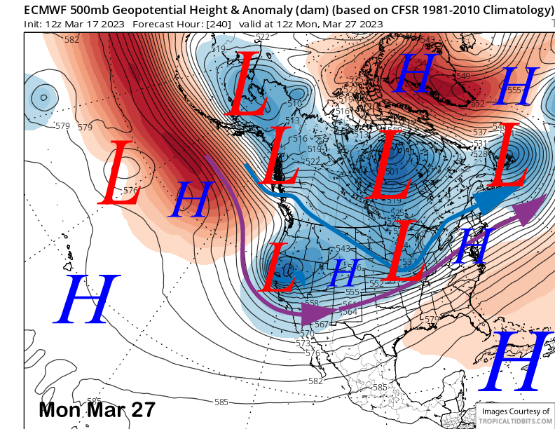
The models then move a deep closed low toward the coast by early Tuesday (ECM below) with most of the energy moving south of Mammoth and into SoCal. But it does look like Mammoth will be far enough southward for pretty good amounts (especially if it was a drought year) with another foot of snowfall possible at Main.
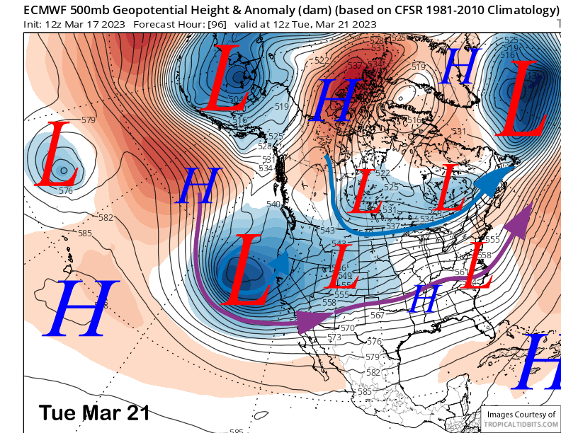
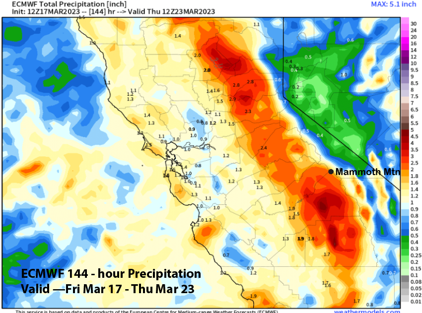
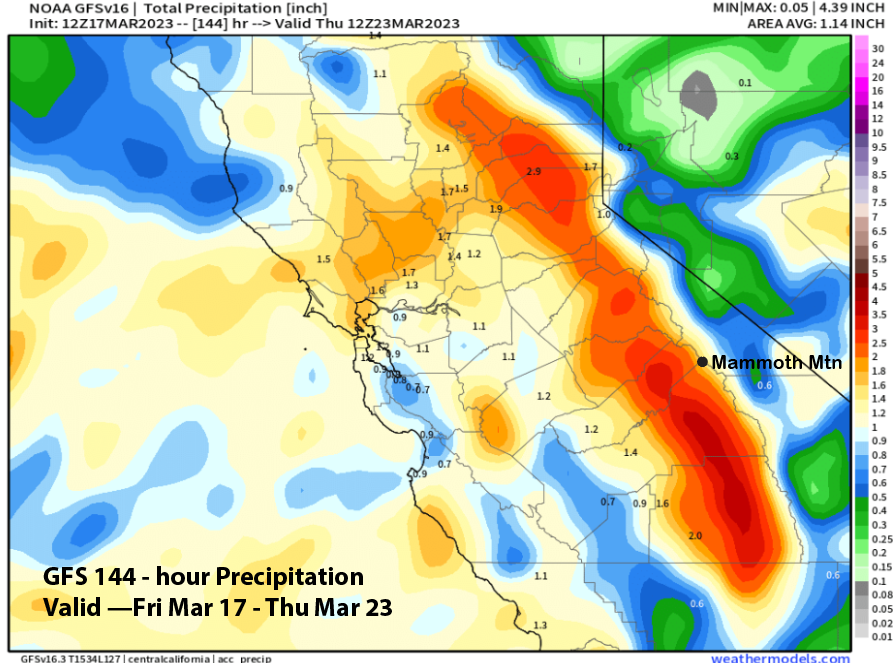
The ECM models has around another inch of liquid with the storm and around 2” liquid for the three day period (image below). The GFS model has slightly less (two images below) and just under 2” liquid. Snow should start again Tuesday morning with continued snow showers through Wednesday, but most of the snowfall will occur on Tuesday.
Snow levels with this storm will be the lowest of the bunch and around 4000 feet or slightly lower by Tuesday night and early Wednesday. This will be a lighter type powder with snow ratios probably in the 12”:1” range. Storm riding over the period should be good as the winds don’t look too strong over the period and the powder should be excellent by Monday and Tuesday with the colder temps.
Long Range (Days 5+)
The longer-range guidance is showing a continued winter-like weather pattern through the end of the month including more powder day chances. But it does seem like the intensity will taper off as winter transitions to spring next week.
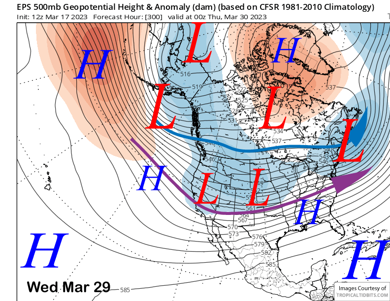
The GFS ensemble mean (image below) and ECM EPS are both showing a weak trough remaining in place for the end of next week after the passage of the closed low through SoCal. That could mean a weak system may move through with light snowfall around Friday, but not a big storm with dry weather likely over the next weekend.
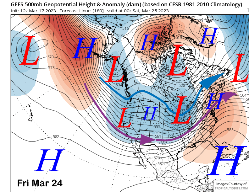
The longer-range guidance suggests the long-wave trough will remain in place along the West Coast early over the following week per the GFS ensemble mean (image below). The latest ECM deterministic run (two images below) has only a moderate strength upper-level trough moving through the state for light snowfall, but the mean of the ensembles support a moderate strength system from the Gulf of Alaska, similar to the GFS.
So, there could be a colder type storm for Mammoth with lower liquid amounts, but more typical snow ratios and not Sierra cement. This pattern is similar to the one that occurred at the end of February and early March, just not as strong or deep.
The ECM EPS in the fantasy range moves the long-wave trough eastward mid-week (image below) that week before possible re-establishing it over the following weekend (two images below). The GFS ensemble is mostly similar. Thus, a winter-like pattern may continue through the end of the month with any storms on the colder and weaker side of the spectrum.
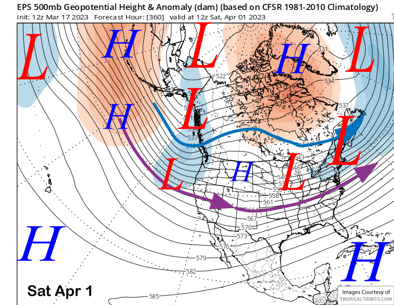
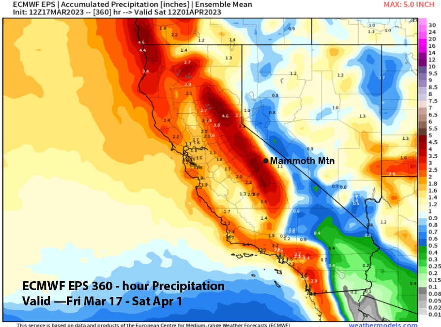
The ECM EPS is showing about 3” liquid for the period (image below) that goes through the end of March. That means another two feet of snowfall is probable with a chance for 3-4 feet if some of the stronger solutions verify. Mammoth needs about 52” to break the snowfall record from 2010-11 (which is actually exaggerated as they double counted a few times that season), but looking at the pictures that Snowman just posted, I think we broke it a while ago, I’ve never seen Main Lodge so buried. WG