Powder Forecast – Friday, February 2nd, 2024
Ted Schlaepfer CCM —- Mammoth Mountain WeatherGuy
Snowfall forecasts are valid at the Sesame snow course (Main Lodge) for the prior 24 hours, as reported in the 6-7 AM morning snow report.
**Snowfall forecast confidence ranges from very low (1) to very high (5)
Sat 2/3 = 2– 3” (H20 = 0.20” – 0.25”)**4
Sun 2/4 = 8 – 10” (H20 = 0.75” – 1.00”)**3
Mon 2/5 = 32 – 38” (H20 = 3.50” – 4.00”)**3
Tue 2/6 = 5 – 7” (H20 = 0.50” – 0.75”)**3
Wed 2/7 = ~2” (H20 = 0.25” – 0.30”)
Thu 2/8 = 2 – 4”
Fri 2/9 = 2 – 4”
Sat – Mon 2/10 – 2/12 = 0 – 3”
February Snowfall = 25”
February Forecast = 80 – 100”
Detailed 4-day Snowfall Forecast:
Sat 2/3 – Any lingering snow showers end during the morning with only flurries expected for the rest of the day, then snowfall increases late evening and overnight. Accumulations by Sunday AM 8 – 10” at Main, up to 12” up top
Sun 2/4 – Heavy snowfall and strong winds develop during the day and continue into the evening followed by moderate to heavy snowfall at times overnight. Accumulations by Monday AM 32 – 38” at Main, 44”+ up top
Mon 2/5 – Snow, heavy at times during the morning, changes to snow showers during the afternoon and evening. Accumulations by Tuesday AM 5 – 7” at Main, up to 10” up top
Tue 2/6 – Snow showers, moderate at times, increase during the day before decreasing overnight. Accumulations by Wednesday AM ~2” at Main, 3”+ up top
Forecast Summary:
Short Term (Days 1 – 4):
The current infrared satellite image (below) today shows a deep and cold low-pressure system off the PacNW coast and a developing storm well off the coast in the eastern Pacific. A sub-synoptic trough associated with the deep low will move into Sierra tonight and keep the snow showers ongoing through the late evening before ending overnight.
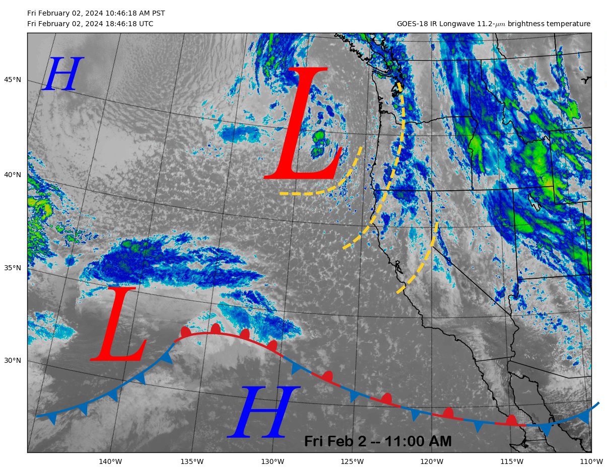
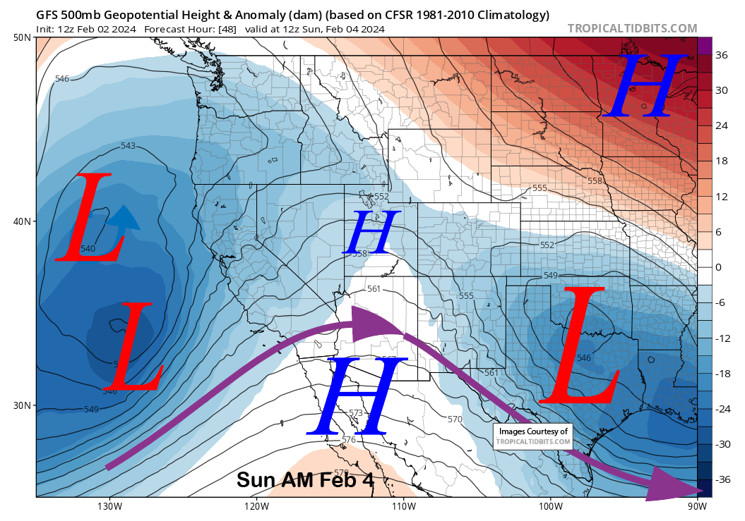
The upper-level low off the PacNW coast will combine with the low-pressure system currently in the eastern Pacific (images below) and deepen as it moves into CA. It is a perfect combination of colder air with the low (blue arrow) meeting subtropical moisture within the southern branch of the jet stream (purple arrow). The result will be cyclogenesis of a surface low pressure system as the trough moves toward CA. It will be very windy in Central CA on Sunday.

It will also get very snowy in Mammoth, with snowfall developing Saturday evening and overnight before becoming heavy on Sunday with strong winds too. There is a good chance most of the mountain will be closed on Sunday. Snowfall should continue into Monday, with snow showers at times through Tuesday before the storm event ends.
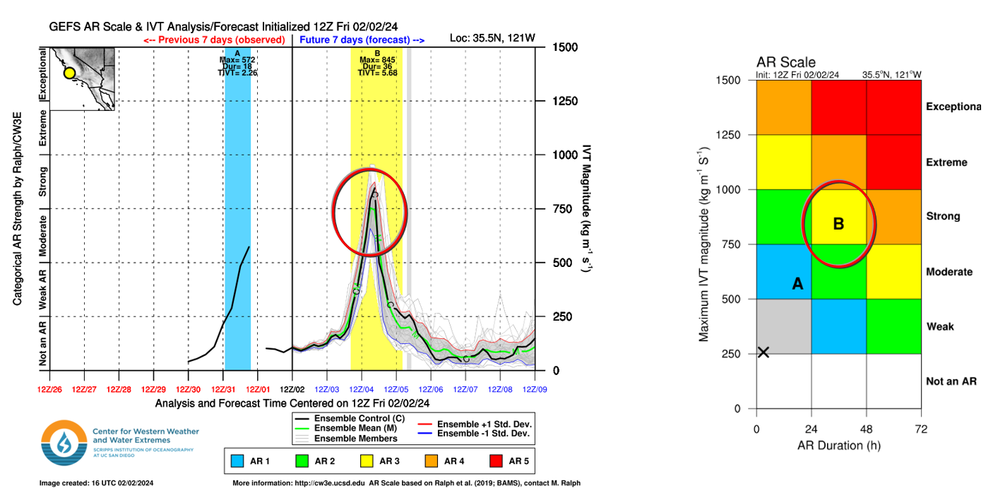
The storm will have a moderate-strength Atmospheric River (image below) associated with it, and that will help provide the moisture for big snowfall amounts. Snow levels look to start around 5500 feet Saturday night before rising to around 7000 feet during the Sunday. Snow levels will come back down to near 5000-5000 feet on Monday/Tuesday and then maybe slightly lower by early Wednesday. That means it will be mostly Sierra cement or base-type snowfall.
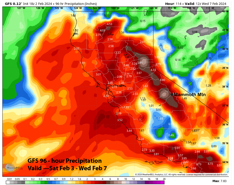
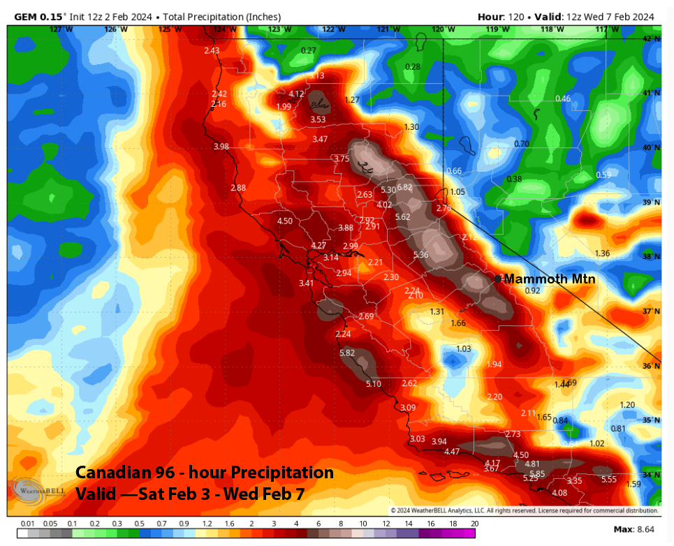
Model QPF varies a bit, with the latest run of the ECM, the driest (image below) at a little over 3.5 inches and the GFS showing about 5” liquid (two images below). The Canadian is in between the two again at around 4.5” with 7” on the western slopes.
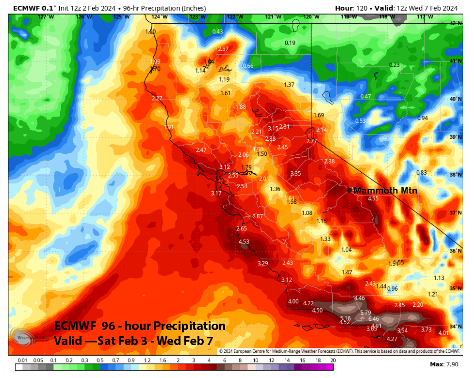
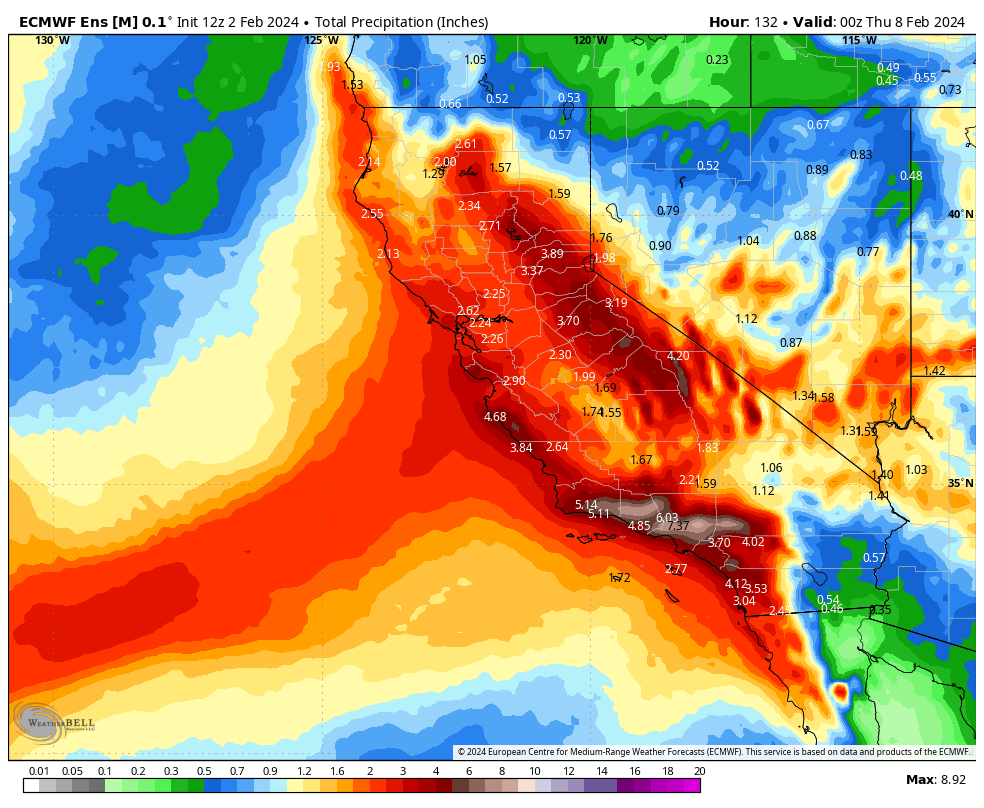
The ECM EPS is slightly wetter than the latest deterministic run at around 4”, and the forecast follows the wetter GFS model due to the good moisture availability. If anything, it may end up even slightly higher than the wetter model forecasts. That should result in about 4 feet of snow at Main through Tuesday and five-plus feet up top.
Long Range (Days 5+):
The longer-range guidance suggests that there could be more snowfall toward the end of next week before a dry period sets in over the following week that should last for a while. Snowfall may then return sometime around the 20th.
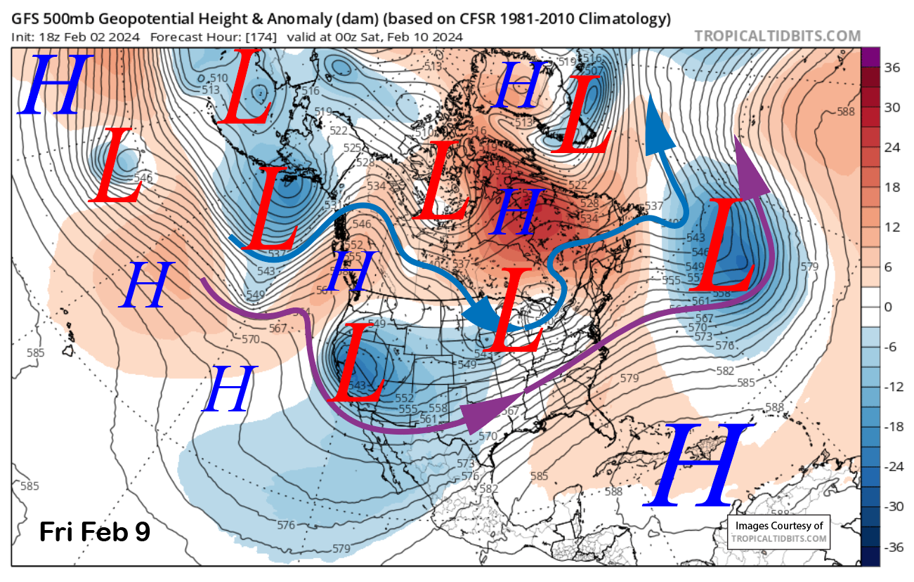
The GFS model moves a short-wave trough into CA around next Friday (image below), and the Canadian model has it too. But the ECM model has it as a slider-type storm with no snowfall and dry. Regardless, it doesn’t appear to be a big storm, with any snowfall amounts remaining light to moderate.
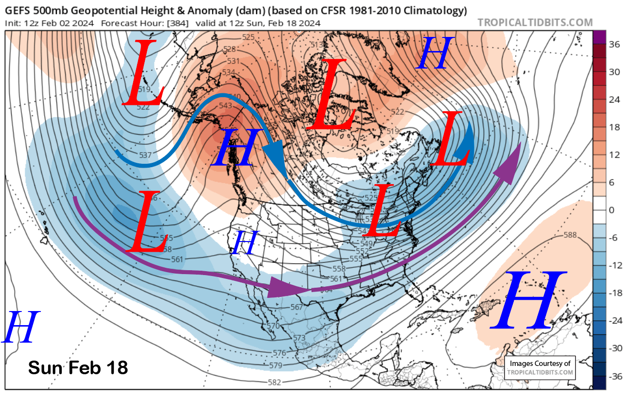
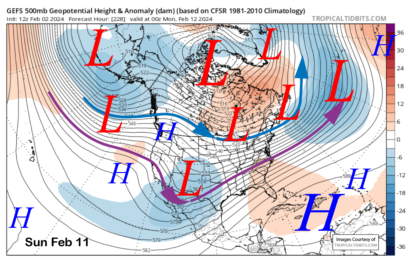
The models then develop a ridge of high pressure (image below) over the following weekend, and that ridge should hold through the next week for fair and dry weather.
The fantasy range guidance keeps the ridge in place and dry weather for the rest of the forecast period, with the last frame (image below) hinting that there could be another breakthrough of the westerlies around the 20th. The ECM EPS is showing this scenario as well. Thus the next chance for snowfall will be over the third week of the month. WG