Powder Forecast – Tuesday, May 7th, 2024
Ted Schlaepfer CCM —- Mammoth Mountain WeatherGuy
Snowfall forecasts are valid at the Sesame snow course (Main Lodge) for the prior 24 hours, as reported in the 6-7 AM morning snow report.
Last Post of the season unless it snows around the 20-21st
**Snowfall forecast confidence ranges from very low (1) to very high (5)
Wed 5/8 = 0”
Thu 5/9 = 0”
Fri 5/10 = 0”
Sat 5/11= 0”
Sun 5/12 = 0”
Mon 5/13 = 0”
Tue 5/14 = 0”
Wed – Fri 5/15 – 5/17 = 0”
May Snowfall: 10”
May Forecast = ~10”
Detailed 4-day Snowfall Forecast
Wed 5/8 through Sat 5/11 – No snowfall expected all days.
Forecast Summary:
Short Term (Days 1 – 4):
The current infrared satellite image (below) shows high pressure in the eastern Pacific and a low pressure system across the interior West.

The weather system in the interior PacNW will move eastward over the next couple of days, and the high-pressure area will replace it. A piece of energy from the upper low will remain parked over the Southwest (image below), and Mammoth will be between the two weather features. The northeast flow will make it breezy at times through Thursday but also keep temperatures from warming up too quickly, with temperatures up top remaining in the 30s.

High pressure will then build more strongly over the state this weekend and into next week (image below) for fair and warmer weather. Spring conditions should be in full effect across the mountain.

Long Range (Days 5+):
The longer-range guidance favors spring conditions continuing through mid-month before cooler weather is possible after mid-month and into the fourth week, with a slight chance of precipitation.
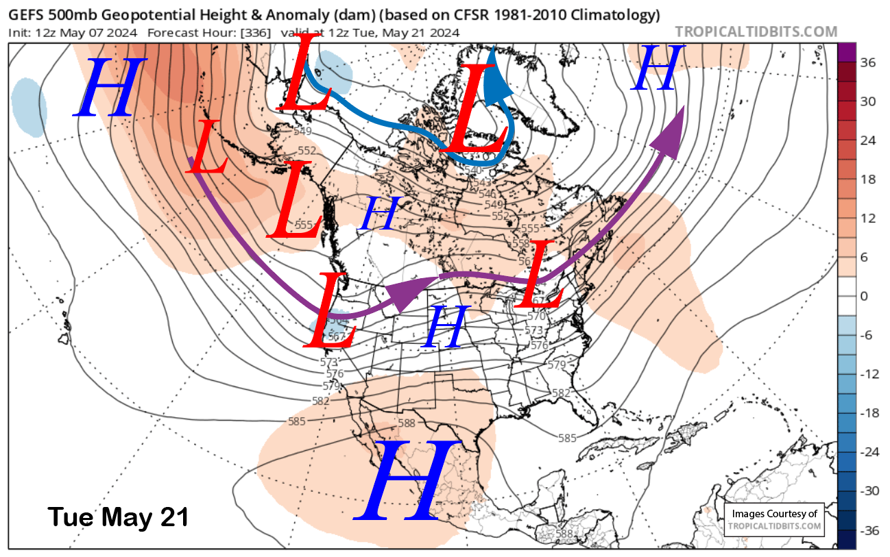
The GFS ensemble is showing a longwave trough developing along the West Coast and extending southward into CA around the 18th of the month and peaking in southward projection around the 20th and 21st (image below). That projection is not far enough southward for any snowfall at Mammoth, but the 6z GFS deterministic run from last night (image below) did have a short wave trough far enough southward for snowfall in Mammoth (two images below).

That run showed about 0.75” liquid from the storm (image below), which would result in about six inches of snowfall. The ECM EPS also has a longwave trough along the West Coast, but it is weaker and farther north with the jet stream. The QPF from that model (two images below) only shows about a tenth of an inch of liquid and a snowfall forecast of about an inch or two (three images below). That would be mostly dust on the crust.


The only reason I bring this potential chance to light is that, during the last fading El Nino in 2019, it snowed over six inches on May 20-21, a similar time frame as what is currently being shown by the GFS ensemble. If it has happened before, it could happen again.
The super long-range ECM EPS is showing about an inch of liquid for the rest of May, with most of that occurring after the 20th. If this season does have one more surprise in it, then I’ll be back to update the Powder Forecast it; otherwise, have a great rest of spring on the mountain and enjoy the upcoming summer. WG


