Ted Schlaepfer CCM —- Mammoth Mountain WeatherGuy
Snowfall forecasts are valid at the Sesame snow course (Main Lodge) for the prior 24 hours as reported in the 6-7 AM morning snow report.
**Snowfall forecast confidence ranges from very low (1) to very high (5)
Sat 11/30 = 6 – 8” (H20 = 0.20” -0.25”)**4
Sun 12/1 = 7 – 9” (H20 = 0.60” -0.75”)**4
Mon 12/2 = 24 – 26” (H20 = 2.50” -2.75”)**3
Tue 12/3 = 4 – 6” (H20 = 0.65” -0.85”)**3
Wed 12/4 = 0”
Thu 12/5 = 2 – 5”
Fri 12/6 = 0”
Sat – Mon 12/7– 12/9 = 18– 24”
November Snowfall = 46”
November Forecast = ~ 50”
Detailed 4-day Snowfall Forecast:
Sat 11/30 —Dry through early afternoon, then snow develop by late PM and evening and becomes moderate overnight. A little windy, but not too bad. Accumulations 7 – 9” by Sun AM with 12” up top
Sun 12/1 —Heavy snow develops during the morning and continues into the evening before decreasing into early Monday. Windy, but not super strong and mostly under 60 mph. Accumulations 21– 26” by Mon AM with 30”+ up top
Mon 12/2 —Moderate snow continues at times through the afternoon before tapering off during the evening and overnight. Breezy to gusty. Accumulations 5– 8” by Tue AM with 10”+ up top
Tue 12/3 — A chance for a snow shower or two, otherwise mostly dry and warmer. No accumulation expected.
Forecast Summary:
Short Term (Days 1 – 4):
The storm system has now mostly moved eastward with only a few lingering snow showers this afternoon after delivering as promised with over 3” liquid resulting in about four feet of powder at Main and six feet up top.
The next storm system will quickly arrive on its heals with snow expected to start tomorrow afternoon as trough of low pressure (image below) sets up in the eastern Pacific and taps some subtropical moisture in the form of a weak atmospheric river (AR) aimed right into the Sierra (purple arrow).
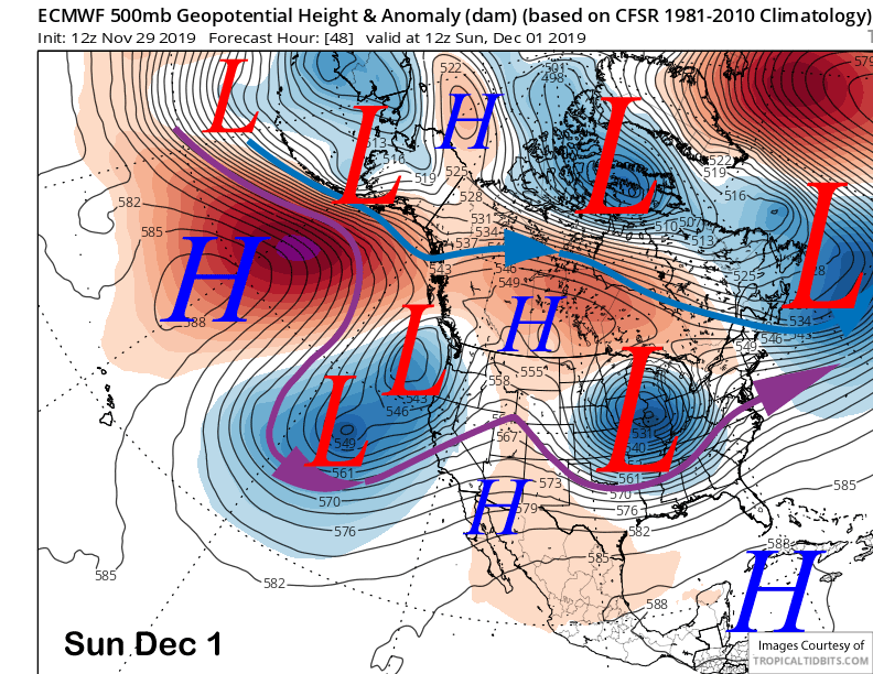
The system will not move typically inland, but linger just off the coast through Monday (image below) with the AR lifting northward Sunday night before likely moving back southward Monday into the Mammoth area.
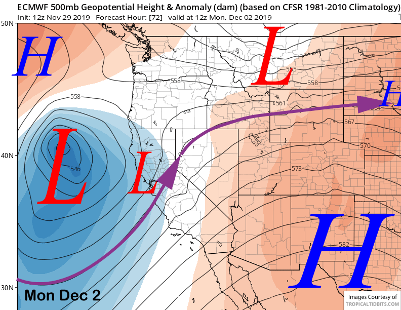
That means heavy snow is expected Sunday during the day and into Sunday evening before decreasing heading into early Monday. Snow should then increase again Monday morning before tapering off by Tuesday as there will be dry period before the system eventually moves into SoCal mid-week.
This storm system will be warmer than the last one with snow levels rising to 6000 feet by Sunday midday and then possibly up to 7500 by Monday. That means it will be the more typical Sierra cement and not like the blower powder from the current storm. Wet snow falling on dry snow should increase the avy danger considerably.
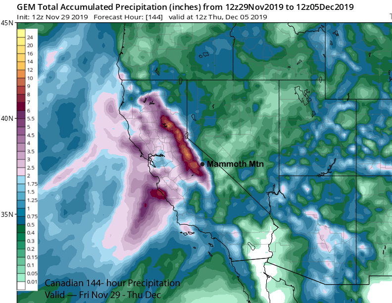
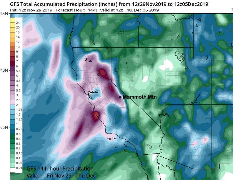
Model quantitative precipitation forecast range from about 3-5 inches for the event with the GFS (image below) on the dry side at around 3 inches while the Canadian (two images below) at close to 5 inches is on the wet spectrum. ECM is around 4 inches liquid and snow ratios this time should be close to normal and around 10”:1”. That should result in about another three feet at Main and close to four up top and more powder days.
Long Range (Days 5+):
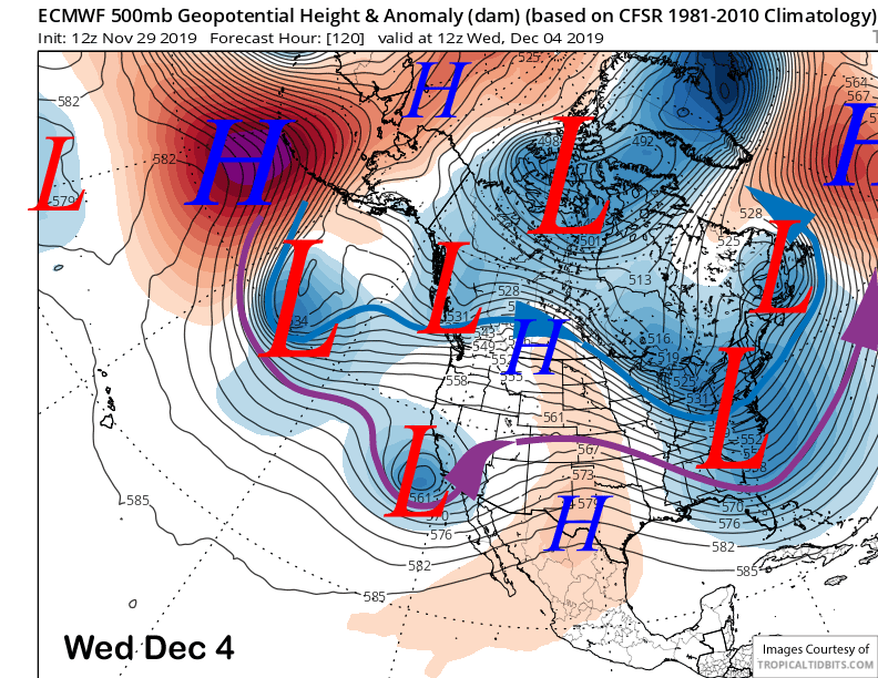
The system will move into SoCal around next Wednesday (image below) and Mammoth will be on the northern fringe of the precipitation. It still looks like there could be another few inches during its passage, but nothing significant. Dry weather should then return for a couple of days.
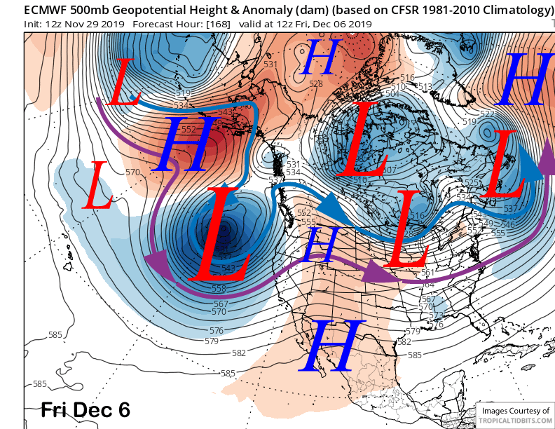
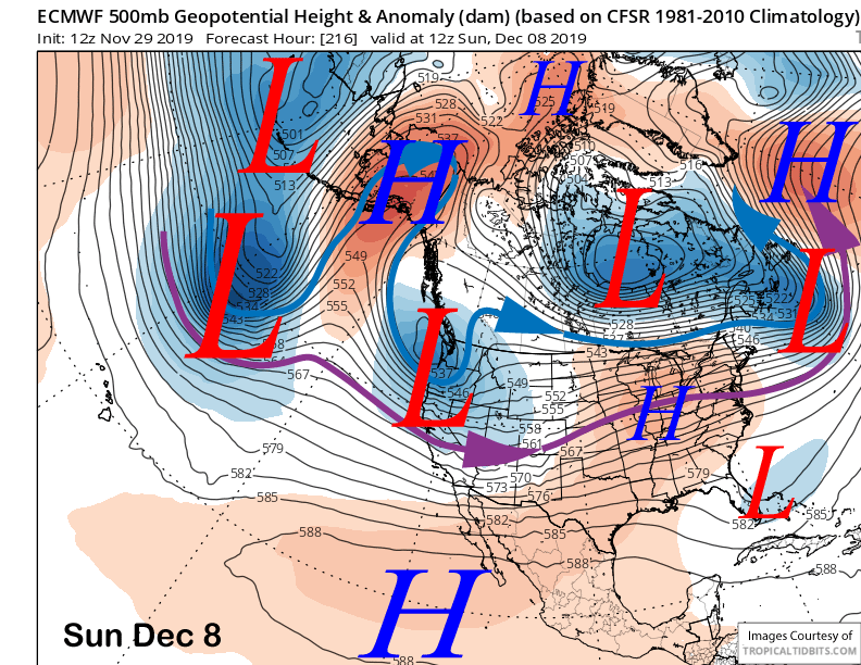
The dry spell will be short-lived as the longer range guidance moves another strong storm system into California by late Friday (image below) and over the following weekend (two images below). Current guidance suggests that another two feet or more could fall for more powder days. It is a ways out, so we can’t bank that yet.
Nonetheless, after a very dry start to the season, the weather has quickly turned more favorable and it now looks like there will be an above normal snow-pack for early December and hopefully a good rest of the season. No complaints here, but we have seen the storm door shut-off quickly in past seasons after a good start, so get the goods now. WG


