Powder Forecast –Tuesday March 9th, 2021
Ted Schlaepfer CCM —- Mammoth Mountain WeatherGuy
Snowfall forecasts are valid at the Sesame snow course (Main Lodge) for the prior 24 hours as reported in the 6-7 AM morning snow report.
**Snowfall forecast confidence ranges from very low (1) to very high (5)
Wed 3/10 = 9 – 12” (H20 = 0.70” – 0.85”)**3
Thu 3/11 = 3 – 5” (H20 = 0.20” – 0.30”)**3
Fri 3/12 = 2 – 3” (H20 = 0.20” – 0.25”)**3
Sat 3/13 = 0 – 1”
Sun 3/14 = 0”
Mon 3/15 = 2 – 4”
Tue 3/16 = 0 – 2”
Wed – Fri 3/17 – 3/19 = 0 – 4”
March Snowfall = 0”
March Forecast = 25 – 40”
Detailed 4-day Snowfall Forecast:
Wed 3/10 –Moderate to heavy snowfall during the morning changes to snow showers during the afternoon and evening before tapering off overnight. Accumulations 9 – 11” by Wednesday AM, 12+” up top; an additional 3 – 5” by Thursday AM, ~6” up top.
Thu 3/11 – Likely dry during the morning, then snowfall increases during the afternoon and evening before tapering off overnight. Accumulations 2 – 3” by Friday AM, 4”+ up top
Fri 3/12 – A chance for an afternoon snow shower or flurry. Little or no accumulation expected,
Sat 3/13 – No snowfall expected.
Forecast Summary:
Short Term (Days 1 – 4):
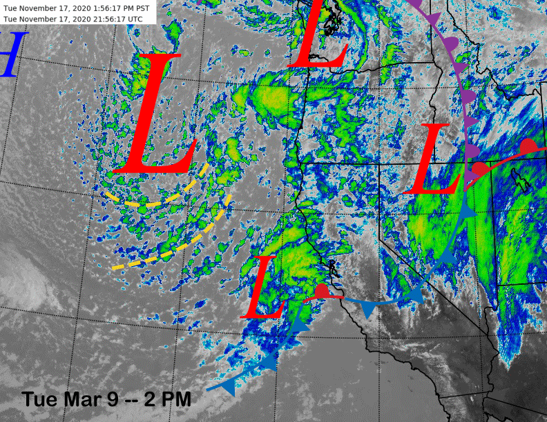
The infrared satellite image (below) this afternoon shows a deep upper level low pressure system positioned off the West Coast moving southward toward CA. A secondary cold front is just off the Bay Area coast and will move inland this evening and overnight increasing precipitation across central and northern California.
The models move the upper low closer to the coast by early tomorrow morning (image below) and that is when the heaviest snowfall is expected across the Sierra. The jet dynamics are not exactly strong and thus orographic enhancement from the Sierra will be rather minimal.
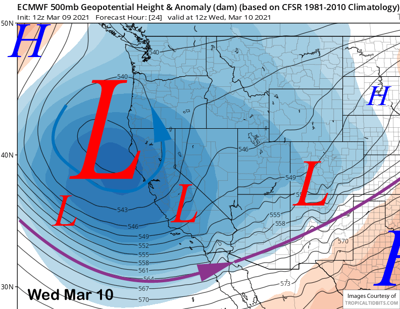
Nonetheless, the secondary cold front should produce more than a foot of snowfall by mid-morning with continued snow showers during the day and into tomorrow evening before tapering off overnight. Conditions tomorrow will be low-end epic.
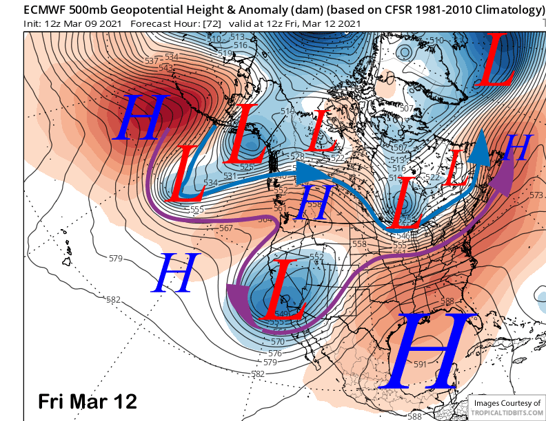
The models slowly move the upper low into SoCal by Friday (image below) and wrap-around snowfall is forecast to increase Thursday afternoon and continue through the evening hours before ending overnight. Friday will be dry during the morning followed by a chance for an instability snow shower during the afternoon. Saturday is forecast to be a sunny day with continued winter-like temperatures.
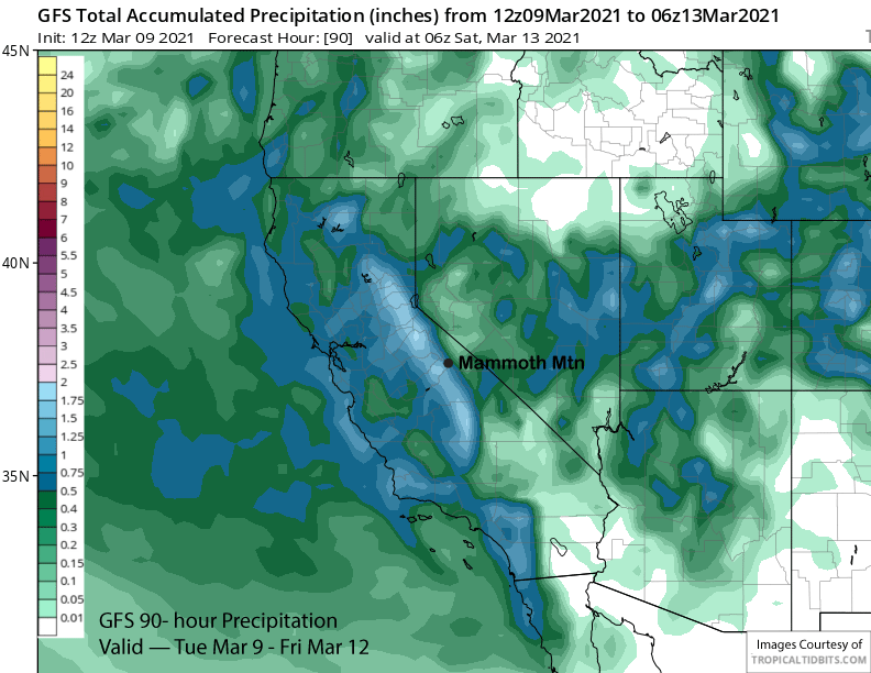
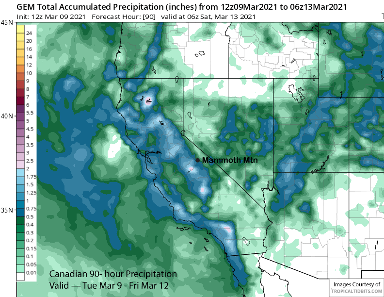
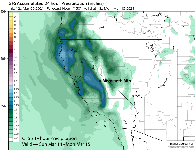
Total liquid amounts with the storm forecast by the GFS (image below) and ECM are expected to be about 1.00”-1.25”, although the Canadian is forecasting less (two images below). That will translate to about 15-20” of total snowfall as the storm is cold (snow levels around 3000 feet) and snow ratios will be in the 15”:1” range of fluffy dry powder. Temps tomorrow will be in the single digits up top and teens to low 20s elsewhere with only a few degrees of warming expected Thursday.
Long Range (Days 5+):
The longer-range guidance is generally full of uncertainty with a couple chances for snowfall, but probably nothing significant as of yet.
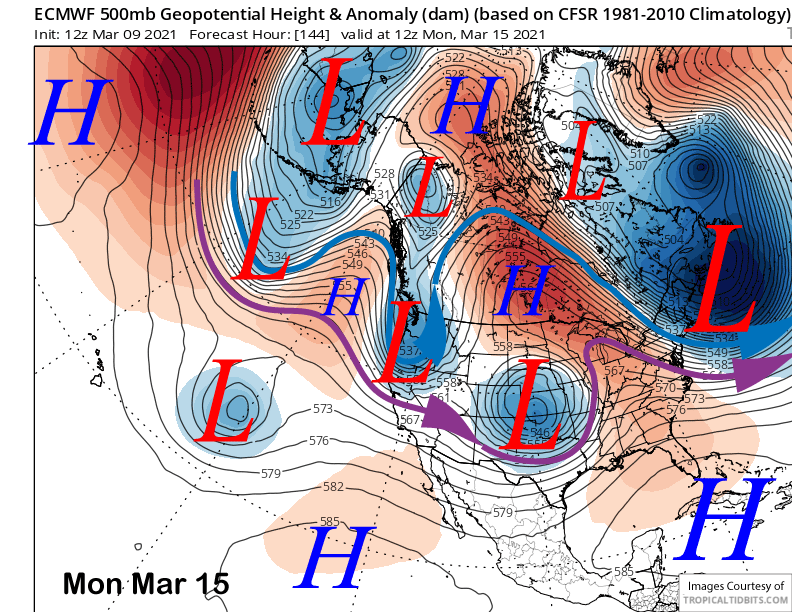
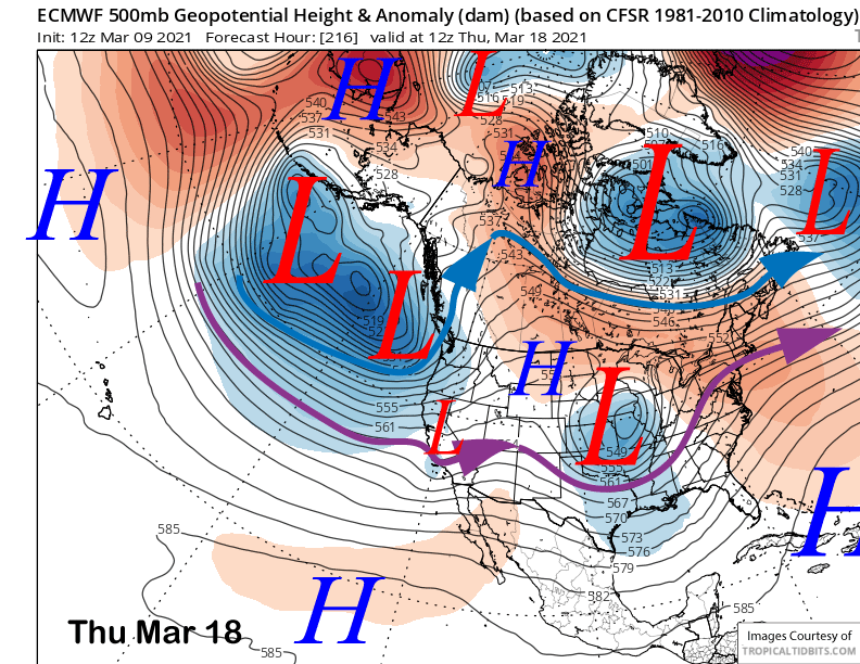
The ECM model moves an upper level low pressure system through northern CA on Sunday and into Monday (image below), but keeps the precipitation north of Mammoth. The Canadian has the system as an inside slider and no snowfall while the GFS (two images below) cuts it off from the jet stream and moves it down the coast as the wettest model.
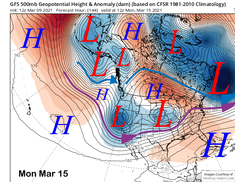
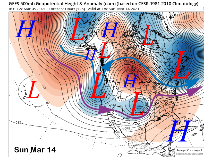
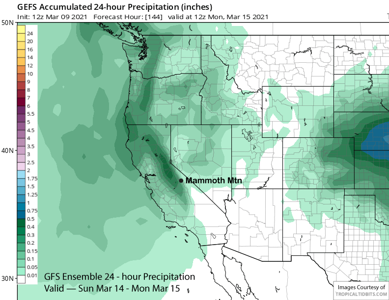
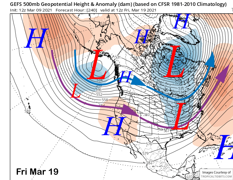
Any of those solutions are possible with the GFS ensemble mean (image below) favoring something closer to the GFS operational solution. The current forecast follows the GFS ensemble that has about 0.35” (two images below) and is also in line with the ECM ensemble mean. Hopefully one of the wetter solutions like the GFS operational model (3 images below) will verify as 2-4″ might not be enough snowfall for powder conditions.
Beyond that, the ECM moves a weak, but moisture laden short-wave into CA around Wednesday night and/or Thursday (image below) next week for a round of light snowfall. The Canadian ensemble is closer to the ECM with weak zonal flow into CA and some snowfall. A few of the GFS ensembles are similar, but the mean of the ensembles (two images below) favors weak ridging for the rest of the week and into the following weekend for fair/dry weather.
Current forecast takes into account the uncertainty and has a chance for a weak storm end of next week along with also a chance for continued dry weather. There is also a slight chance for a stronger storm as about 8 of the 51 ECM ensembles are showing a storm with more than a inch of liquid.
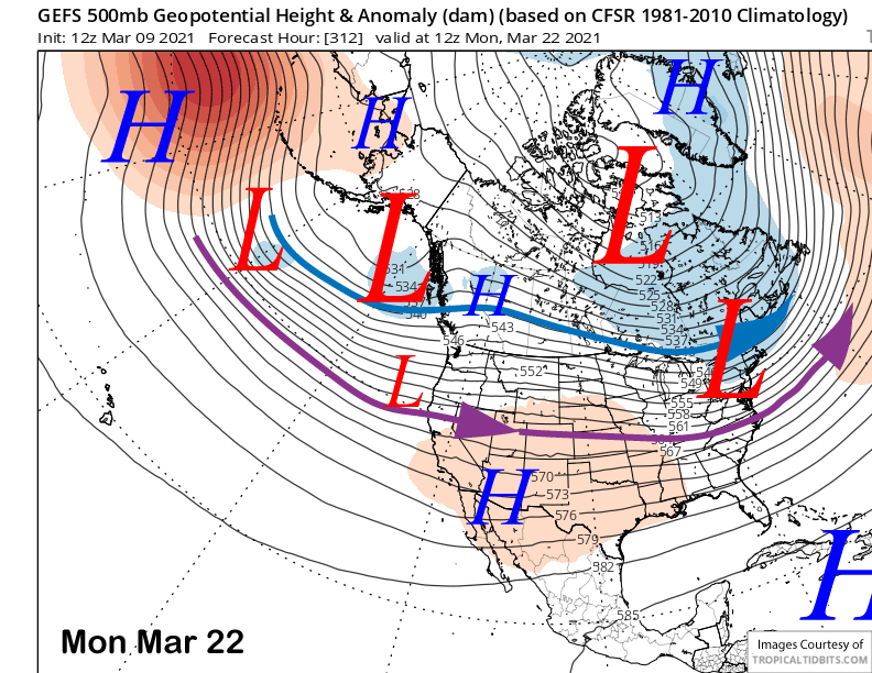
The GFS ensemble does flatten out the ridge early over the following week (image below) and projects zonal flow into the West Coast, but unfortunately, with the southern branch of the jet stream (purple arrow) too far north for any significant precipitation in Mammoth. However, the Canadian ensemble is father southward and would allow storm systems to move into Mammoth.
Overall, this has been a rough season as far as powder days are concerned with only a few days so far outside of the big storm end of January. It looks like tomorrow and Thursday will be two more. Hopefully we can keep adding to that total before the storm track retreats northward for the start of the dry season in a month or so. WG