Powder Forecast – Tuesday, December 8th, 2020
Ted Schlaepfer CCM —- Mammoth Mountain WeatherGuy
Snowfall forecasts are valid at the Sesame snow course (Main Lodge) for the prior 24 hours as reported in the 6-7 AM morning snow report.
**Snowfall forecast confidence ranges from very low (1) to very high (5)
Wed 12/9 = 0”
Thu 12/10 = 0”
Fri 12/11 = 0”
Sat 12/12 = 0”
Sun 12/13 = 0”
Mon 12/14 = 0 – 2”
Tue 12/15 = 0 – 3”
Wed – Fri 12/16 – 18 = 3 – 10”
December Snowfall = 0”
December Forecast = 25 – 40”
Detailed 4-day Snowfall Forecast:
Wed 12/9 through Sat 12/12 – No snowfall expected all days.
Forecast Summary:
Short Term (Days 1 – 4):
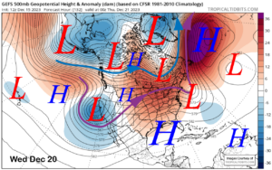
The infrared satellite image (below) this afternoon shows high pressure situated across the West and a cut-off low pressure system off the Baja coast that moved through the Mammoth area Sunday night and early Monday with the northeast winds.

High pressure will continue to hold over the area for the next few days for continued dry weather and seasonably mild temperatures. The models then move an upper level low (image below) through the northeastern part of the state and Nevada Friday for colder temperatures and increased northwest winds, but no snowfall,

Winds should increase Thursday night and continue through Friday before decreasing Friday night. Fair and dry weather should then continue through Saturday.
Long Range (Days 5+):
The longer-range guidance is still showing the West Coast ridge finally flattening as predicted by some of the models next week (mid-month). Now we wait and see whether the storms will move far enough southward to bring significant snowfall for the Mammoth region.
The ECM model moves the first storm north of Mammoth Sunday night and early Monday (image below) and only has light snow showers or flurries. The latest GFS is similar after showing the precipitation farther southward in early runs.

Only the Canadian model (image below) has a favorable solution for meaningful snowfall as that model moves the upper-low much farther southward than the other models. Only a few of the ECM ensemble solutions move the trough that far south and it seems like an outlier solution right now.

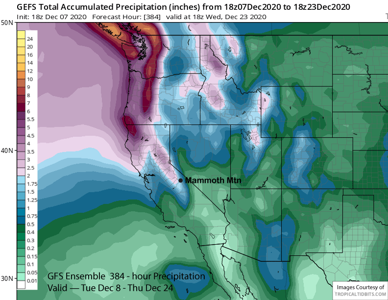
The ECM model then moves a weak system through NorCal around Wednesday (image below) next week and the model does have some light snow as far south as Mammoth. The GFS is much deeper with the trough and also slower and has a decent storm for Central and Northern California with about 0.50″ liquid or around 6” of snow for Mammoth by Thursdsay.

The ECM does appear to deepen the trough at the end of the forecast period (image below) and that may result in more significant snowfall toward the end of next week per that model. Overall, the ECM model is the driest of the model suites. The GFS is a little wetter, but it doesn’t show anything significant in the 10-day period (two images below) with only about 0.50” liquid with that Wednesday night storm.


The Canadian model is the wettest over the last couple of runs and definitely with the 12Z run this morning. It is much deeper with the upper level trough around the middle part of next week (image below) and produces significant snowfall for Mammoth and the Sierra over the 10 day period with nearly 6” liquid for Mammoth (two images below). Let’s hope this happens.


The GFS ensemble mean does keep a trough along the West Coast into the following weekend (image below) for further chances of snowfall, but the jet stream is generally too far northward for major snowfall. It then rebuilds the ridge weakly in the extended timeframe for more dry weather.

Overall, the GFS deterministic runs have shown a few storms in the 15-day period and the latest run is showing about 1.5” liquid in the 10-day period (image below). The GFS ensemble mean is similar or slightly wetter for the period (image below). So the best forecast right now is for some light/moderate snowfall next week and at times into the following weekend that could add up to a foot or so.

The latest ECM climate model run has mostly dry weather during the Christmas period with the next chance a period of snowy weather toward the end of the year or early January. With the MJO forecast to remain in dry phase 5 (image below) through Christmas, extended wet periods are not likely until it finally moves westward into the wetter phases 6-8 during early January. WG