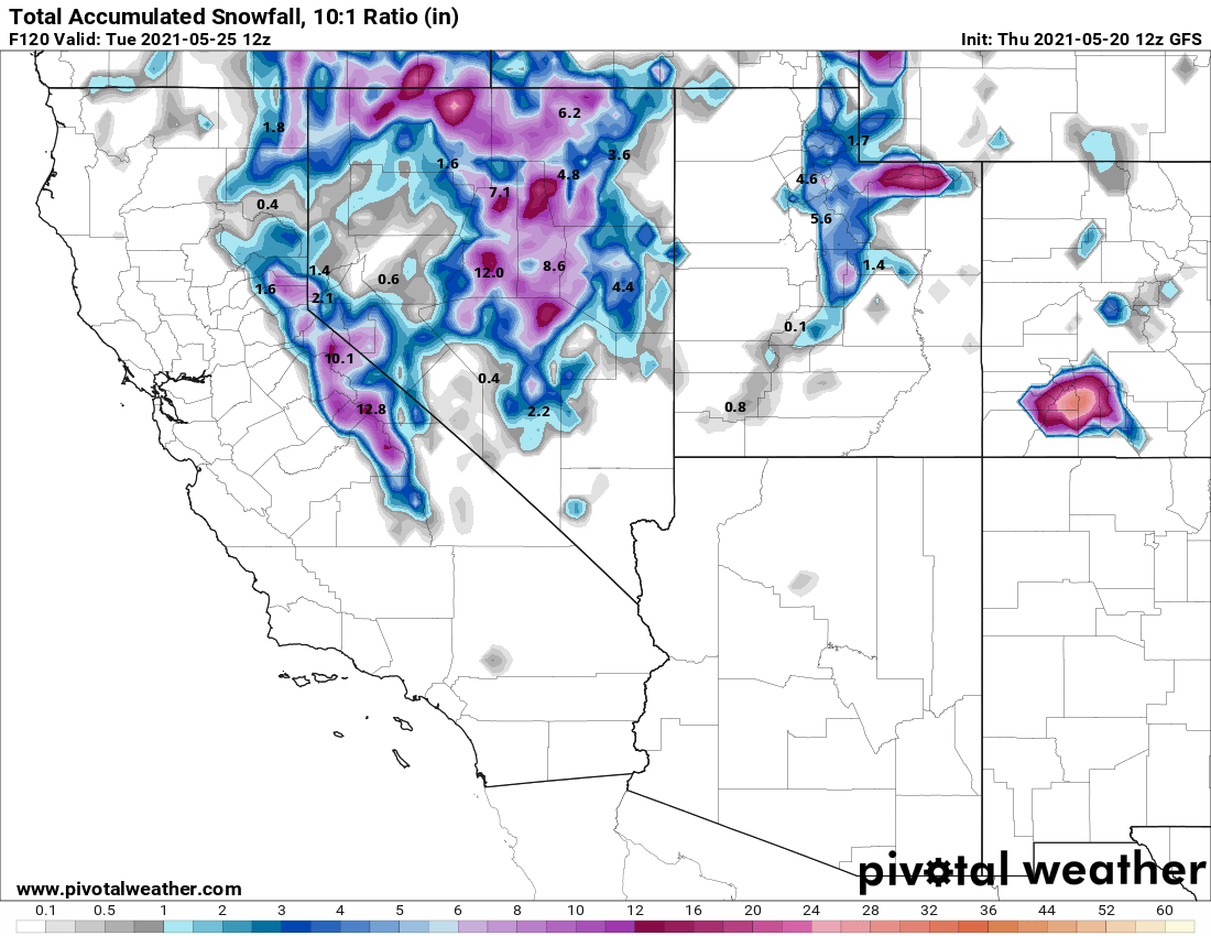
5-20-2021 Thursday @ 12:51 PM Updated Summary: A strong spring storm system is moving into Northern California this afternoon.
That system looks to make its way into the Eastern Sierra overnight bringing with it high elevation snows. There will also be some light rain showers at times for the lower elevations.
On Friday the snowfall looks to become possibly heavy at times in areas above 8500 feet. The snow that we are expecting will be heavy and wet. Most likely in the 8-1 range looking at the forecasted temperatures.
Snow showers look to continue to be moderate at times Friday night into Saturday afternoon for elevations above 8500-9000 feet.
Accumulations
Right now accumulations are forecast to be in the 5-10 inches range from 9000 feet up to the Sierra Crest. The newest models that came out just a couple of hours ago showed amounts up to a foot possible over the Sierra Crest.
With as warm as it has been and with the warm temperatures forecasted on Friday these amounts might be too high.
For Mammoth Lakes, there could be several inches of snow from this system on the ground by Friday evening especially in the higher elevations of town.
Down on 395, we are not expecting any chain controls but you never know I would be prepared for anything from this late May system.
Wind Forecast
The low-pressure system moving in is already producing moderate to strong winds @ 25-45 MPH. These winds are being observed from Bishop to Mammoth Lakes this afternoon.
Over the next few days, we expect the winds to back off a bit but still be in the moderate range over the higher elevations. Winds will be blowing out of the southwest. Expect wind speeds 15 to 25 mph, with gusts as high as 30-40 mph possible over the higher elevations.
Forecasted Highs and Lows
Temperatures forecasted for Friday and Saturday at the Mammoth Mountain Main Lodge and the Mammoth Lakes Basin (at the 8900-foot level.)
Highs will be in the low to mid-30s with nighttime lows in the upper teens to low 20s through Saturday night. By Sunday the high warm to around 46 with a 55 on Monday.
Mammoth Lakes (at the 7900-foot level) will be in the upper 30s to low 40s with lows well down into the low to mid-20s through Saturday night. By Sunday the forecast is for a 55 in town with a 63 by Monday.
For Crowley Lake and Long Valley (at the 7000-foot level) on Friday highs will be in the mid-40s with night times lows down into the low to mid-20s.
By Saturday highs will be into the low 50s with upper 20s for overnight lows. It warms quickly with highs near 61 on Sunday and 70 by Monday.
Down in Bishop and Round Valley where we could also see some rain showers and T Storms the next couple of days.
Highs will be in the upper 50s to low 60s on Friday with mid-60s for Saturday and mid-70s on Sunday. The ’80s then return on Monday under clear blue skies.
Have a great day and enjoy the weather, Snowman out