Mammoth Mountain Weather Forecast

Thursday, October 19th @ 9:45 AM – The Mammoth Weather Story… The next couple of days will be it for the well above-average highs and calm conditions that have been with us for over a week now.

By Saturday the first inside slider of the season will be dropping into the great basin. For Mammoth Mountain and the Eastern Sierra, there will be a 15-20 degree drop in the temperatures from today to Sunday.

The winds will be back on Saturday with gusts exceeding 80+ MPH over the highest ridge tops with winds in Mammoth Lakes up to 35 MPH. Looks for gusts down on 395 and in the Bishop area to be 30-40+ MPH at times on Saturday and Saturday night.

Saturday will also offer up some cloudy skies with snow showers above the 8400-foot level. I would expect to see a dusting of white at Main Lodge on Sunday morning with up to an inch possible over the top.

Mammoth Mountain Weather Forecast: Thursday into Friday expect mostly clear skies with dry conditions. Resort level highs at 8900 feet (Main Lodge and the Mammoth Lakes Basin) will be in the upper 50s by mid-day, with overnight lows into the low to mid-40s.

By Saturday highs will be into the low 40s and then low to mid-30s for Sunday. Lows by Sunday at sunrise should be down in the low 20s with possible upper teens on Monday morning.

Mammoth Lakes Weather Forecast:  Thursday into Friday expect mostly clear skies with dry conditions. Highs will be in the low 60s with overnight lows in the 40s.

For the weekend break out the winter layers’ highs will be in the 40s Saturday and the 30s on Sunday. Look for a morning low on Sunday around 21… brrrr

If you’re venturing to Bishop expect clear skies with highs in the low 80s with nighttime lows in the 40s through Friday. By Saturday there is a wind advisory with highs in the low 70s with upper 50s expected on Sunday along with lows right near the 32-degree mark. There could also be a few raindrops around Bishop and on 395.

Here are the links to the specific highs, lows, and wind speeds for many of the major recreation points in the Eastern Sierra: Mammoth Mountain Main Lodge, Top of Mammoth Mountain, Mammoth Lakes, June Lake, Crowley Lake, Toms Place, Rock Creek Lake, Bishop & Mill Pond, South Lake. 

Mammoth WeatherGuy Powder Outlooks will be back in early November. Here is the link to all of Ted’s past posts.

Read down the page for all the longer-range outlooks for snow this November and the Winter of 2023. If you have questions about the weather or weather-related chat use our Weather forum.

Current Satellite View

North Pacific Satelite View
Local Radar
Local Radar
Mammoth Mountain Weather Discussion & Data

10-19-22 @ 7:30 AM – Beyond this weekend expect cool days and nights with marginal snowmaking by midweek, the next chance for some snow and colder weather looks to be at the end of next week into the following weekend.

Models are not in total agreement yet, but they are trending for a second low with more cold air and a dusting to several inches of snow possible. Let’s hope that system evolves into something stronger.

Below you have the GEFS Ensemble in Spaghetti Format. Lots of agreement in the low making it into California this weekend as you can see both the control and mean runs drop right into the Mammoth area.

The pattern change on the GEFS has been showing for days now and is looking more and more likely.

Here is the QPF forecast from all 4 of the models we look at. As expected not a lot of moisture is coming in with the system this weekend. Could be enough to get that first dusting that turns the ground a bit white. 

10 Day QPF Forecast
10 Day QPF Forecast

Below you can see all 50 of the EPS ensemble model outcomes for snowfall out 16 days.

Here is the EPS Ensemble Model going out 10 days.

EPS – 7 Day Snowfall Forecast from the EPS Mean

EPS Temperature Anomaly Ensemble Mean – Nice to see some nice blue cold air into the area on the gif below. Snowmaking crews should be able to make some snow.

Long Range Fantasy Snowfall Outlook for November

10-19-22 @ 7 AM  The fresh EPS 45 weeklies came out on Monday, unlike the last run that went crazy on snowfall, this run seems more reasonable in the long range trend for expected snowfall in November.

Overall at this point in time, November looks to be below average for snowfall with some decent periods of cold air for snowmaking.

There will also be some shorter periods of warm and dry weather. If you recall last November it was cold and wet the first week of the month and then the 3 week warm and dry cycle set in.

As of now, the best news is models do not have a large ridge parked over the area for 21 days this November.

Snowman

Looking at the first image below you have the high-resolution EPS Control Run and just below that the EPS Means run. Both these models have 2-3+ feet of snow for the month of November. Again to note, this is not a forecast but a long-range outlook that we use to look at where the trends in the weather are headed.

The GEFS 800-Hour run today for snowfall continues to look decent for this time of year, however, this is inches, not footage.

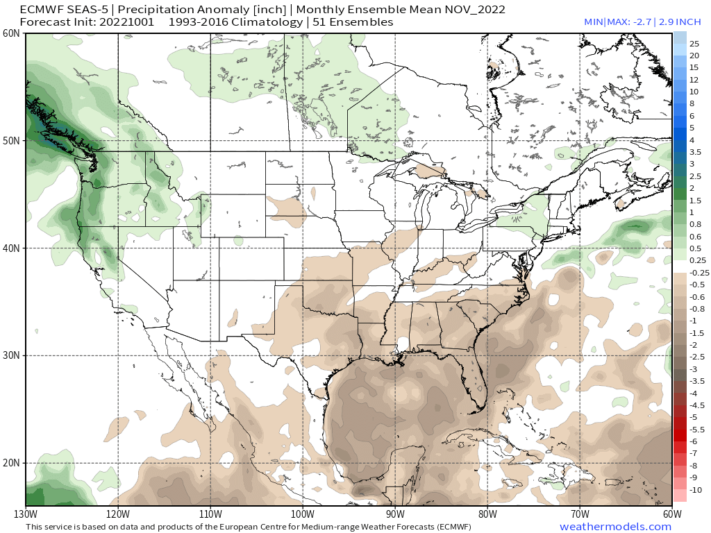
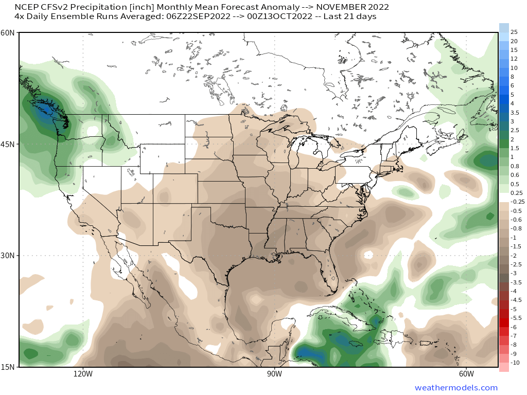
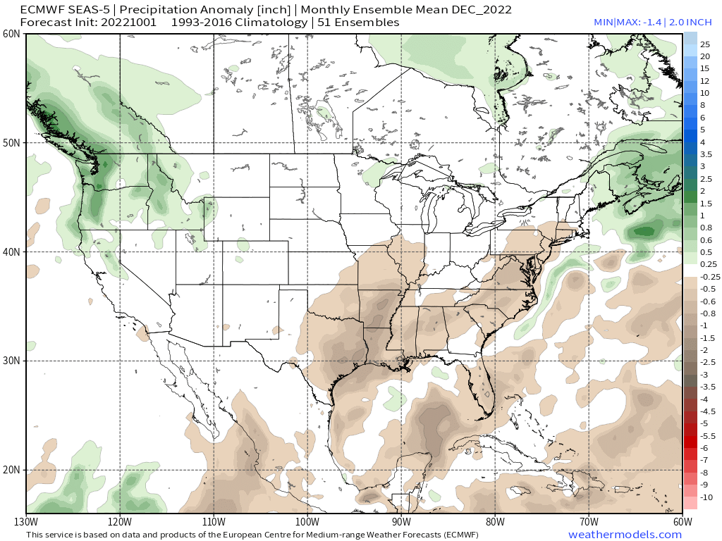
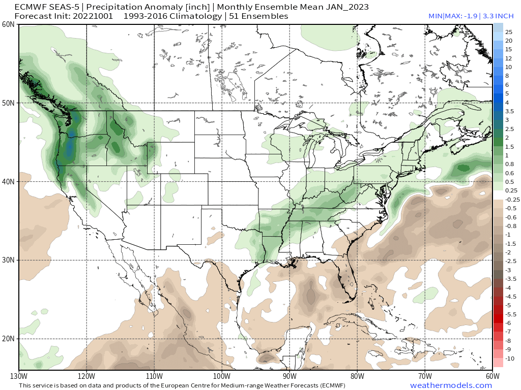
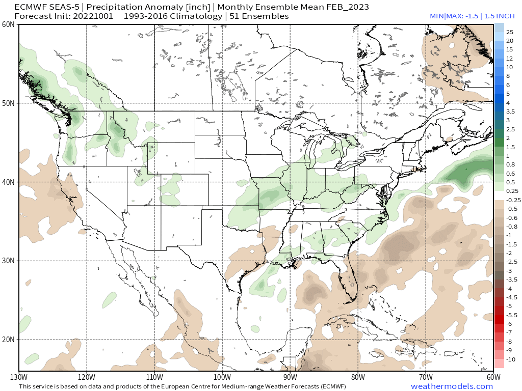
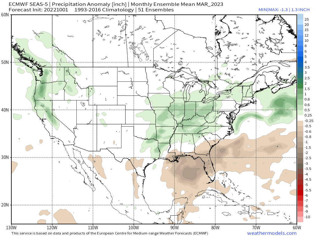
 Here is the EPS Seasonal November Monthly Forecast and the forecast chart for the first 3 months of the season. Mammoth Mountain is right on the white and green lines. The white line equals average Snowfall.


seas5_qpfa_3mon_conus_NDJ


November into March Mammoth Weather Trends

10-5-2022 @ 11 AM – The new run of the EPS Seasonal is out and it continues to show the trend of an average to above-average winter for snowfall. Each run has been getting a bit wetter and this month’s run is the best looking yet.

Of course, now it has to pan out over the next 6 months and this data is no guarantee Mammoth Mountain will get dumped on. Last year at this time the only wet month the seasonal EPS had on this date was December and the rest showed red and dark brown drought colors.

So good vibes moving forward as we start the snow and cold air watch now.

Snowman

ENSO - La Nina & El Nino

Mammoth Mountain and Eastern Sierra Weather Posts

Who Are We?

Steve Taylor – Mammoth Snowman Over the last 30+ years, Snowman has spent countless hours studying and learning about Mammoth Mountain Weather and Snow Conditions first hand. He has been skiing around the hill with marked ski poles since March of 1991 so he can measure the fresh snowfall amounts out on the hill. 

Snowman started blogging this information back in 1990 on the old Mammoth BBS system, then the RSN Forums and then on to MammothSnowman.com in 2004 with Video & Photo Blog report. (No YouTube back then). Facebook got added to the fold back in 2008 and then the Facebook Group in 2016. 

Reports, videos, and photos from the website have been featured on both local TV Stations here in Mammoth, along with AP, Fox, ABC, CBS, and NBC News.

Ted Schlaepfer – Mammoth WeatherGuy – The Powder Forecast – Posted Tuesday and Fridays at 5 PM November into Mid May. These forecasts are now responsible for many people getting multiple powder days on Mammoth Mountain over the years.  

Ted’s Bio: Ted has been a full-time Meteorologist (CCM) for the past 25+ years. He has always been fascinated with the weather,” skiing was just a natural extension of my love for snow and rain. I started skiing at age 5,  first discovered Mammoth in 1979 as a youth, and have been a regular visitor since the late ’80s.”.

Here is the link to The WeatherGuys Powder Forecast Page. 

Click Here to Learn More About the People Who Make MammothSnowman.com a Reality